 view gallery view gallery S0.2 km S0.2 km
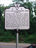
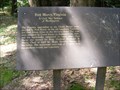
|   Clay and Randolph Duel Clay and Randolph Duel
in Virginia Historical Markers Right along Glebe road southbound at the intersection of Military. parking is along the shoulder of the road. posted by:  flyingmoose flyingmoose location: Virginia date approved: 05/26/2006 last visited: 06/19/2016 |
 view gallery view gallery NW0.2 km NW0.2 km
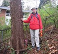
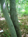
|  Arlington Co. 2006 Champ of Reg'l Signif: Sassafras Arlington Co. 2006 Champ of Reg'l Signif: Sassafras
in Exceptional Trees Arlington Co 2006 Champ of Regional Significance: Sassafras posted by: Lost Geographers location: Virginia date approved: 07/30/2007 last visited: 08/07/2016 |
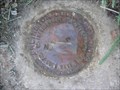 view gallery view galleryS0.3 km |  BN2 BN2
in U.S. Benchmarks BN2 in Arlington, Virginia posted by:  Black Dog Trackers Black Dog Trackers location: Virginia date approved: 04/29/2006 last visited: 06/20/2016 |
 view gallery view galleryS0.3 km | BN3 in U.S. Benchmarks BN3 in Arlington, Virginia.
posted by: Black Dog Trackers location: Virginia date approved: 04/29/2006 last visited: 06/20/2016 |
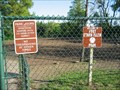 view gallery view gallery SW0.3 km SW0.3 km
|  Fort Ethan Allen Park Fort Ethan Allen Park
in Off-Leash Dog Areas Fort Ethan Allen off-leash dog park.
posted by: Black Dog Trackers location: Virginia date approved: 04/29/2006 last visited: 06/20/2016 |
 view gallery view gallery NE0.5 km NE0.5 km
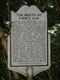
| The Mouth Of Pimmit Run in Virginia Historical Markers Sparse parking nearby or across the bridge in Maryland. posted by: flyingmoose location: Virginia date approved: 05/26/2006 last visited: 06/19/2016 |
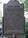 view gallery view galleryNE0.5 km | Chain Bridge in Virginia Historical Markers Sparse parking nearby or across the bridge in Maryland. posted by: flyingmoose location: Virginia date approved: 05/26/2006 last visited: 06/19/2016 |
 view gallery view gallery N0.6 km N0.6 km
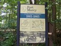
|  Fort Marcy-Fort Circle Parks - McLean, VA Fort Marcy-Fort Circle Parks - McLean, VA
in Military Installations Fort Marcy and nearby Fort Ethan Allen, among other batteries on the northern bank of the Potomac River, were built to protect Leesburg Pike and Chain Bridge. Construction began in 1861. When Fort Marcy was completed, it had a perimeter of 338 feet. posted by: Don.Morfe location: Virginia date approved: 03/18/2022 last visited: 03/19/2022 |
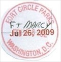 view gallery view galleryN0.6 km |  Fort Marcy-Fort Circle Parks - McLean, VA Fort Marcy-Fort Circle Parks - McLean, VA
in NPS Passport Cancellation Stations Fort Marcy and nearby Fort Ethan Allen, among other batteries on the northern bank of the Potomac River, were built to protect Leesburg Pike and Chain Bridge. Construction began in 1861. When Fort Marcy was completed, it had a perimeter of 338 feet and mounted 18 guns, a 10-inch mortar and two 24-pounder Coehorn mortars. posted by: Don.Morfe location: Virginia date approved: 01/20/2020 last visited: 10/10/2021 |
 view gallery view galleryN0.6 km |  Fort Marcy Park - McLean VA Fort Marcy Park - McLean VA
in Wikipedia Entries Fort Marcy Park is a public park located in unincorporated McLean, Virginia, in Fairfax County. It is administered by the National Park Service as part of the George Washington Memorial Parkway. posted by: Don.Morfe location: Virginia date approved: 03/18/2022 last visited: 03/19/2022 |
 view gallery view galleryN0.6 km | ") Fort Marcy-Fort Circle Parks - McLean, VA Fort Marcy-Fort Circle Parks - McLean, VA
in National Parks (U.S.) Fort Marcy and nearby Fort Ethan Allen, among other batteries on the northern bank of the Potomac River, were built to protect Leesburg Pike and Chain Bridge. Construction began in 1861. When Fort Marcy was completed, it had a perimeter of 338 feet and mounted 18 guns, a 10-inch mortar and two 24-pounder Coehorn mortars. posted by: Don.Morfe location: Virginia date approved: 01/24/2020 last visited: 10/28/2021 |
 view gallery view galleryN0.6 km |  Fort Marcy-Fort Circle Parks - McLean, VA Fort Marcy-Fort Circle Parks - McLean, VA
in National Parks of the World Fort Marcy and nearby Fort Ethan Allen, among other batteries on the northern bank of the Potomac River, were built to protect Leesburg Pike and Chain Bridge. Construction began in 1861. When Fort Marcy was completed, it had a perimeter of 338 feet. posted by: Don.Morfe location: Virginia date approved: 03/19/2022 last visited: 03/19/2022 |
 view gallery view galleryN0.6 km |  Fort Marcy-Fort Circle Parks - McLean, VA Fort Marcy-Fort Circle Parks - McLean, VA
in Official Local Tourism Attractions Fort Marcy and nearby Fort Ethan Allen, among other batteries on the northern bank of the Potomac River, were built to protect Leesburg Pike and Chain Bridge. Construction began in 1861. When Fort Marcy was completed, it had a perimeter of 338 feet. posted by: Don.Morfe location: Virginia date approved: 03/18/2022 last visited: 03/19/2022 |
 view gallery view gallery SE0.6 km SE0.6 km
| Arlington Co.. Champion American Beech in Exceptional Trees Very healthy, double trunk American Beech with wide crown spread. posted by: Lost Geographers location: Virginia date approved: 07/29/2007 last visited: 08/07/2016 |
 view gallery view galleryN0.8 km |  D.C., Maryland, & Virginia - Washington, D.C. D.C., Maryland, & Virginia - Washington, D.C.
in Tripoints and Multipoints Probably one of the more inaccessible tri-points in the region. posted by: flyingmoose location: District of Columbia date approved: 06/08/2021 last visited: never |
 view gallery view galleryNW0.8 km |  Fort Marcy, Virginia-A Civil War Defense of Washington - Mc Lean VA Fort Marcy, Virginia-A Civil War Defense of Washington - Mc Lean VA
in U.S. Civil War Sites The Virginia approaches to the Chain Bridge were guarded by Fort Marcy on the old Leesburg Turnpike and Fort Ethan Allen on the Military Road. These sites were occupied by Union troops on September 24, 1861. posted by: Don.Morfe location: Virginia date approved: 09/06/2020 last visited: 10/04/2021 |
 view gallery view galleryS0.8 km | Arlington Co. 2006 Champion Yellow Pine in Exceptional Trees Arlington County's Champion Yellow Pine for 2006. posted by: Lost Geographers location: Virginia date approved: 07/30/2007 last visited: never |
 view gallery view galleryS0.8 km | Arlington County Champion American Shadbush in Exceptional Trees Marked with orange tag, this American Shadbush is growing in Gulf Branch Nature Center. posted by: Lost Geographers location: Virginia date approved: 07/29/2007 last visited: 06/20/2016 |
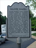 view gallery view gallerySW1 km | Walker Chapel in Virginia Historical Markers Right along the northbound side of Glebe road inbetween route 29 and the chain bridge. Parking is good here. posted by: flyingmoose location: Virginia date approved: 05/26/2006 last visited: 06/19/2016 |
 view gallery view gallerySW1 km | BN1 in U.S. Benchmarks BN1 in Arlington, Virginia posted by: Black Dog Trackers location: Virginia date approved: 04/29/2006 last visited: 08/07/2016 |
 view gallery view gallery E1.3 km E1.3 km
|  Grand Lodge, F.A.A.M. - Washington D.C. Grand Lodge, F.A.A.M. - Washington D.C.
in Masonic Temples Grand Lodge located in North West DC. posted by: flyingmoose location: District of Columbia date approved: 08/03/2020 last visited: never |
 view gallery view galleryN1.3 km |  C&O Canal - Lock #5 C&O Canal - Lock #5
in Waterway Locks, Planes and Lifts Lock #5 (of 74) on the Chesapeake & Ohio Canal - Brookmont Lock - Mile 5.02 posted by: ParrotRob location: Maryland date approved: 05/16/2006 last visited: 08/09/2013 |
 view gallery view galleryNE1.4 km |  John Dugger - Bethesda, Maryland John Dugger - Bethesda, Maryland
in Citizen Memorials Trailside memorial along the Capital Crescent Trail near the old Tunnel. posted by: flyingmoose location: Maryland date approved: 10/15/2020 last visited: never |
 view gallery view gallerySW1.6 km | PHRA7 in U.S. Benchmarks Station PHRA7 in Arlington Virginia. posted by: Black Dog Trackers location: Virginia date approved: 04/29/2006 last visited: 08/21/2016 |
 view gallery view galleryN1.8 km |  Dalecarlia Tunnel B&O Railroad Dalecarlia Tunnel B&O Railroad
in Abandoned Train Tunnels The Dalecarlia Tunnel, built in 1910 as part of the Georgetown Branch of the B&O Railroad, was closed to trains in 1985 and is now part of the Capital Crescent bike/hike trail that extends 7 miles from Georgetown to Silver Spring, Maryland. posted by: whitechalk location: Maryland date approved: 10/17/2011 last visited: 07/30/2014 |
|