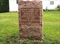
 view gallery view gallery NE0 km NE0 km
|   Boone's Lick Road - Millersburg, MO Boone's Lick Road - Millersburg, MO
in Missouri Historical Markers Last town in Callaway County heading west. posted by:  YoSam. YoSam. location: Missouri date approved: 05/05/2010 last visited: 10/09/2016 |
 view gallery view galleryNE0 km |  Boone's Lick Road - Millersburg, MO Boone's Lick Road - Millersburg, MO
in Wagon Roads and Trails Last town in Callaway County heading west. posted by: YoSam. location: Missouri date approved: 06/03/2014 last visited: 10/09/2016 |
 view gallery view gallery SE0.2 km SE0.2 km
|  Bell from old Millersburg Christian Church - Millersburg, MO Bell from old Millersburg Christian Church - Millersburg, MO
in Bells Millersburg, a residential community. The downtown is just gone, businesses at a minimum. Millersburg is 11 miles West of Fulton. posted by: YoSam. location: Missouri date approved: 03/13/2018 last visited: never |
 view gallery view gallerySE0.2 km |  Millersburg Christian Church Bell Tower - Millersburg, MO Millersburg Christian Church Bell Tower - Millersburg, MO
in Bell Towers Millersburg, a residential community. The downtown is just gone, businesses at a minimum. Millersburg is 11 miles West of Fulton. posted by: YoSam. location: Missouri date approved: 03/11/2018 last visited: never |
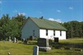
 view gallery view gallerySE0.2 km |  Millersburg Christian Church - Millersburg, MO Millersburg Christian Church - Millersburg, MO
in Continental Reformed and Congregational Church Sites Millersburg, a residential community. The downtown is just gone, businesses at a minimum. Millersburg is 11 miles West of Fulton. posted by: YoSam. location: Missouri date approved: 03/11/2018 last visited: never |
 view gallery view gallerySE0.2 km |  Millersburg Christian Church - Millersburg, MO Millersburg Christian Church - Millersburg, MO
in Country Churches Millersburg, a residential community. The downtown is just gone, businesses at a minimum. Millersburg is 11 miles West of Fulton. posted by: YoSam. location: Missouri date approved: 03/12/2018 last visited: never |
 view gallery view gallery NW0.8 km NW0.8 km
| Millersburg Baptist Church - Millersburg, MO in This Old Church Western edge of what once once a town posted by: YoSam. location: Missouri date approved: 03/11/2018 last visited: never |
 view gallery view galleryNW0.8 km |  Millersburg Baptist Church - Millersburg, MO Millersburg Baptist Church - Millersburg, MO
in Baptist Churches Western edge of what once once a town posted by: YoSam. location: Missouri date approved: 03/10/2018 last visited: never |
 view gallery view galleryNW0.8 km | Millersburg Baptist Church - Millersburg, MO in Country Churches Western edge of what once once a town posted by: YoSam. location: Missouri date approved: 03/12/2018 last visited: never |
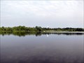 view gallery view gallery N0.8 km N0.8 km
|  Little Dixie Lake - Callaway County MO Little Dixie Lake - Callaway County MO
in Canoe/Kayak Trips Little Dixie is a 205 acre lake created in 1957 by the damming of Owl Creek. Since it is over 70 acres it is a "no-wake lake". Makes a great place to kayak or canoe. posted by: kJfishman location: Missouri date approved: 08/12/2014 last visited: never |
 view gallery view galleryNW1 km |  Millersburg Cemetery - Millersburg, MO Millersburg Cemetery - Millersburg, MO
in Worldwide Cemeteries Cemetery and Baptist church on the same grounds. posted by: YoSam. location: Missouri date approved: 03/11/2018 last visited: never |
 view gallery view galleryNW1 km |  Millersburg Baptist Cemetery - Millersburg, MO Millersburg Baptist Cemetery - Millersburg, MO
in Churchyard Cemeteries Baptist church and cemetery on very large lot posted by: YoSam. location: Missouri date approved: 03/12/2018 last visited: never |
 view gallery view galleryN1.1 km |  Little Dixie Lake - Callaway County MO Little Dixie Lake - Callaway County MO
in Fishing Holes Little Dixie is a 205 acre created in 1957 by the damming of Owl Creek. Since it is over 70 acres it is a "no-wake lake" allowing you to operate gas motors. Great place to kayak or canoe fish. posted by: kJfishman location: Missouri date approved: 08/17/2014 last visited: 11/13/2023 |
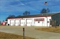 view gallery view galleryNW1.1 km |  Millersburg Fire Protection District Millersburg Fire Protection District
in Firehouses This fire district has only one station posted by: YoSam. location: Missouri date approved: 03/08/2018 last visited: never |
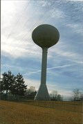 view gallery view galleryN2.4 km |  Water Tower - Millersburg, MO Water Tower - Millersburg, MO
in Water Towers This is a village tower, but, as with so many in this county, nothing on the tank. posted by: YoSam. location: Missouri date approved: 03/01/2018 last visited: never |
 view gallery view galleryN3.7 km |  Little Dixie Lake Conservation Area - Callaway County, MO Little Dixie Lake Conservation Area - Callaway County, MO
in Public Access Lands This is the northern most parking/entrance for this area... posted by: YoSam. location: Missouri date approved: 05/28/2020 last visited: 07/04/2021 |
 view gallery view galleryNW3.9 km | Boone's Lick Road - Boone Bounty, MO in Wagon Roads and Trails The "Boone's Lick Road, first a trail, then a trace, then a road, started by the Boone Boys (Daniel's sons) to transport salt from Franklin County to St. Charles County and a profitable business, later adapted to stagecoach travel. posted by: YoSam. location: Missouri date approved: 05/04/2014 last visited: 10/09/2016 |
 view gallery view galleryNW3.9 km | Boone's Lick Road ~ Vivion's - Millersburg, MO in Missouri Historical Markers Stage Stand on the road to Franklin and to tie up with the Santa Fe Trail. posted by: YoSam. location: Missouri date approved: 05/13/2010 last visited: 10/09/2016 |
 view gallery view galleryNE4.5 km |  2455 Rose Wheel - Callaway County, MO 2455 Rose Wheel - Callaway County, MO
in Wagon Wheels Two houses, side bu side, with similar wheels used as rose trellises. posted by: YoSam. location: Missouri date approved: 04/21/2018 last visited: never |
 view gallery view galleryNE4.5 km | 2451 Rose Wheel - Callaway County, MO in Wagon Wheels Two houses, side bu side, with similar wheels used as rose trellises. posted by: YoSam. location: Missouri date approved: 04/21/2018 last visited: never |
 view gallery view gallerySE5.1 km | White Cloud Presbyterian Church Cemetery - near Fulton, MO in Churchyard Cemeteries Church moved from Millersburg to this site in 1847, original church burnt down, and new one built in 1888 posted by: YoSam. location: Missouri date approved: 10/18/2017 last visited: never |
 view gallery view gallerySE5.1 km | White Cloud Presbyterian Church Cemetery - near Millersburg, MO in Worldwide Cemeteries Church moved from Millersburg to this site in 1847, original church burnt down, and new one built in 1888 posted by: YoSam. location: Missouri date approved: 10/17/2017 last visited: never |
 view gallery view gallerySE5.1 km |  White Cloud Presbyterian Church Privy - near Millersburg, MO White Cloud Presbyterian Church Privy - near Millersburg, MO
in Outhouses This privy is not as well kept as others of it time. posted by: YoSam. location: Missouri date approved: 10/18/2017 last visited: never |
 view gallery view gallerySE5.1 km |  White Cloud Presbyterian Church - Callaway County, MO White Cloud Presbyterian Church - Callaway County, MO
in Presbyterian Churches Very old church, now used primarily as a cemetery chapel posted by: YoSam. location: Missouri date approved: 10/17/2017 last visited: never |
 view gallery view gallerySE5.1 km |  White Cloud Presbyterian Church - Callaway County, MO White Cloud Presbyterian Church - Callaway County, MO
in U.S. National Register of Historic Places Very old church, now used primarily as a cemetery chapel posted by: YoSam. location: Missouri date approved: 10/18/2017 last visited: never |
|