 view gallery view gallery NE0 km NE0 km
|   History of McBaine - McBaine, MO History of McBaine - McBaine, MO
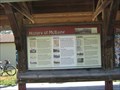
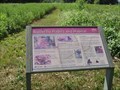
in Missouri Historical Markers Town history, the disasters and successes. Included is the last plank road built in Missouri. posted by:  YoSam. YoSam. location: Missouri date approved: 07/18/2022 last visited: 01/05/2024 |
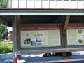
 view gallery view galleryNE0 km | McBaine to Harstburg - McBaine, MO in Missouri Historical Markers A location and site marker at the McBaine Trailhead. It has information for the traveler to "look-out" for on their trip. posted by: YoSam. location: Missouri date approved: 07/21/2022 last visited: 01/05/2024 |
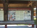 view gallery view galleryNE0 km | The Plank Road, Columbia-Providence - McBaine, MO in Missouri Historical Markers Marker located at the McBaine Trailhead, north of this road site. posted by: YoSam. location: Missouri date approved: 07/14/2022 last visited: 01/05/2024 |
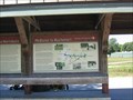 view gallery view galleryNE0 km | McBaine to Rocheport - McBaine, MO in Missouri Historical Markers A location and site marker at the McBaine Trailhead. It has information for the traveler to "look-out" for on their trip. posted by: YoSam. location: Missouri date approved: 07/17/2022 last visited: 01/05/2024 |
 view gallery view galleryNE0 km |  FIRST - Train in McBaine & settler in Central Missouri - McBaine, MO FIRST - Train in McBaine & settler in Central Missouri - McBaine, MO
in First of its Kind Missouri river bottom town suffered at the floods, but rains and settlers kept coming. posted by: YoSam. location: Missouri date approved: 07/18/2022 last visited: 01/05/2024 |
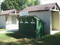 view gallery view galleryNE0 km |  Recycle Box - Katy Trail State Park - McBaine, MO Recycle Box - Katy Trail State Park - McBaine, MO
in Places for Recycling Three chamber box at the trailhead for bicycle riders to deposit their recyclable trash. posted by: YoSam. location: Missouri date approved: 07/15/2022 last visited: never |
 view gallery view galleryNE0 km |  McBaine to Harstburg - McBaine, MO McBaine to Harstburg - McBaine, MO
in Flora and Fauna Information Signs A location and site marker at the McBaine Trailhead. It has information for the traveler to "look-out" for on their trip. posted by: YoSam. location: Missouri date approved: 07/20/2022 last visited: 01/05/2024 |
 view gallery view galleryNE0 km |  History of McBaine - McBaine, MO USA History of McBaine - McBaine, MO USA
in Human Migration Monuments Town history, the disasters and successes. Included is the last plank road built in Missouri. posted by: YoSam. location: Missouri date approved: 08/01/2022 last visited: 01/05/2024 |
 view gallery view galleryNE0 km |  History of McBaine - 1800 - 2010 - McBaine, MO History of McBaine - 1800 - 2010 - McBaine, MO
in Timelines Town history, the disasters and successes. Included is the last plank road built in Missouri. posted by: YoSam. location: Missouri date approved: 07/20/2022 last visited: 01/05/2024 |
 view gallery view galleryNE0 km |  Katy Trail - McBaine, MO Katy Trail - McBaine, MO
in Rails to Trails Katy Trail State Park is built on the former corridor of the Missouri-Kansas-Texas (MKT) Railroad (better known as the Katy). This trail head is about center, and just west of Columbia, of the State Park. posted by: YoSam. location: Missouri date approved: 07/11/2022 last visited: 01/05/2024 |
 view gallery view galleryNE0 km |  David Randal Malorin - McBaine, MO David Randal Malorin - McBaine, MO
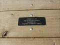
in Dedicated Benches At the Katy Trailhead site, both benches and the picnic table dedicated to Mr. Malorin. David Malorin worked as an Environmental Supervisor for the State of Missouri and in 2019. posted by: YoSam. location: Missouri date approved: 07/11/2022 last visited: never |
 view gallery view galleryNE0 km | "Bill" Scofield - McBaine, MO in Dedicated Benches A bench at the Katy Trail Trailhead in McBaine posted by: YoSam. location: Missouri date approved: 07/12/2022 last visited: never |
 view gallery view galleryNE0.2 km |  Butterfly Habits and Habitats & Garden - McBaine, MO Butterfly Habits and Habitats & Garden - McBaine, MO
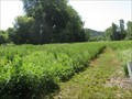
in Demonstration Gardens Large patch of protected land for butterfly habitat, and the marker that explains and teaches about these creatures. posted by: YoSam. location: Missouri date approved: 08/12/2022 last visited: 01/05/2024 |
 view gallery view galleryNE0.2 km | Butterflies Habits - McBaine, MO in Flora and Fauna Information Signs Sign explaining it all in front of butterfly garden. posted by: YoSam. location: Missouri date approved: 07/12/2022 last visited: 01/05/2024 |
 view gallery view galleryNE0.2 km |  Katy Trail State Park Butterfly Garden - McBaine, MO Katy Trail State Park Butterfly Garden - McBaine, MO
in Butterfly Gardens Large patch of land next to the McBaine Trailhead preserved for butterfly habitat. posted by: YoSam. location: Missouri date approved: 08/12/2022 last visited: never |
 view gallery view galleryNE0.2 km | Butterfly Habits and Habitats - McBaine, MO in Missouri Historical Markers Large patch of protected land for butterflies and a teaching marker and site. posted by: YoSam. location: Missouri date approved: 07/12/2022 last visited: never |
 view gallery view gallery W0.2 km W0.2 km
|  McBaine, Missouri McBaine, Missouri
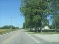
in People-Named Places Between floods and the railroads leaving, not much left of this town. posted by: YoSam. location: Missouri date approved: 07/09/2022 last visited: 01/05/2024 |
 view gallery view galleryW0.2 km |  McBaine, Missouri McBaine, Missouri
in Wikipedia Entries Between floods and the railroads leaving, not much left of this town. posted by: YoSam. location: Missouri date approved: 07/09/2022 last visited: 01/05/2024 |
 view gallery view gallery NW0.3 km NW0.3 km
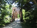
|  Perche Creek Bridge - Katy Trail - McBaine, MO Perche Creek Bridge - Katy Trail - McBaine, MO
in Railroad Bridges On the old MKT Railroad line, now the Katy Trail State Park and over Perche Creek. posted by: YoSam. location: Missouri date approved: 07/09/2022 last visited: 01/05/2024 |
 view gallery view galleryNW0.3 km |  Perche Creek Bridge - Katy Trail - McBaine, MO Perche Creek Bridge - Katy Trail - McBaine, MO
in Orphaned Bridges On the old MKT Railroad line, now the Katy Trail State Park and over Perche Creek. posted by: YoSam. location: Missouri date approved: 07/08/2022 last visited: 01/05/2024 |
 view gallery view galleryNW0.3 km |  Perche Creek Bridge - Katy Trail - McBaine, MO Perche Creek Bridge - Katy Trail - McBaine, MO
in Truss Bridges On the old MKT Railroad line, now the Katy Trail State Park and over Perche Creek. With Bridgehunters passing his links no longer work. posted by: YoSam. location: Missouri date approved: 07/08/2022 last visited: 01/05/2024 |
 view gallery view galleryNW0.3 km |  Perche Creek Bridge - 1897 - McBaine, MO Perche Creek Bridge - 1897 - McBaine, MO
in Bridge Date Stones and Plaques On the old MKT Railroad line, now the Katy Trail State Park and over Perche Creek. Since Bridgehunter passed away his links no longer work, but the information is still accurate. posted by: YoSam. location: Missouri date approved: 04/08/2024 last visited: never |
 view gallery view gallery E0.3 km E0.3 km
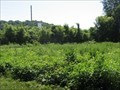
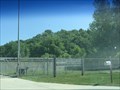
|  Columbia's aging McBaine Water Treatment Plant is on the Verge of a Much-needed Upgrade - McBaine, MO Columbia's aging McBaine Water Treatment Plant is on the Verge of a Much-needed Upgrade - McBaine, MO
in News Article Locations Columbia, MO, water treatment facility and tower in the Missouri River flood plain. posted by: YoSam. location: Missouri date approved: 08/31/2022 last visited: never |
 view gallery view galleryE0.3 km |  Treatment Plant Water Tower - McBaine, MO Treatment Plant Water Tower - McBaine, MO
in Water Towers Columbia, MO, water treatment facility and tower in the Missouri River flood plain. posted by: YoSam. location: Missouri date approved: 08/30/2022 last visited: never |
 view gallery view gallery SW0.3 km SW0.3 km
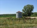
|  Small Farm Silo - McBaine, MO Small Farm Silo - McBaine, MO
in Solitary Silos Was a farm house once here? posted by: YoSam. location: Missouri date approved: 07/09/2022 last visited: 01/05/2024 |
|