 view gallery view gallery N1 km N1 km
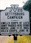
|   Gettysburg Campaign Gettysburg Campaign
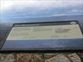
in Virginia Historical Markers A marker along Ewell's path toward Gettysburg. posted by:  Markerman62 Markerman62 location: Virginia date approved: 03/22/2015 last visited: 03/29/2015 |
 view gallery view galleryN1 km |  Chester Gap Chester Gap
in Civil War Discovery Trail Sites Chester Gap was an important pass through the Blue Ridge Mountains for both the Union and Confederate armies to move troops and supplies. posted by:  La de Boheme La de Boheme location: Virginia date approved: 06/04/2012 last visited: never |
 view gallery view gallery W6.1 km W6.1 km
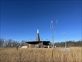
|  Linden VORTAC - Linden, Virginia Linden VORTAC - Linden, Virginia
in Ground Based Air Navigation Support Structures Located off of the Dickey Ridge Trail in the Shenandoah National Park. posted by: flyingmoose location: Virginia date approved: 12/23/2022 last visited: never |
 view gallery view galleryW6.4 km |  Shanandoah National Park-Dickey Ridge Shanandoah National Park-Dickey Ridge
in NPS Passport Cancellation Stations The Dickey Ridge Visitor Center is located at Milepost 4.6 of Skyline Drive in Shenandoah National Park in Warren County, Virginia posted by: Don.Morfe location: Virginia date approved: 12/25/2019 last visited: 10/10/2021 |
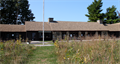
 view gallery view galleryW6.4 km |  Dickey Ridge Visitors Center Shenandoah Valley Skyline Drive in Virginia. Dickey Ridge Visitors Center Shenandoah Valley Skyline Drive in Virginia.
in Compass Roses The Dickey Ridge Visitors Center is located on the northern end of the Skyline Drive in the Shenandoah National Park in Virginia. posted by: Lat34North location: Virginia date approved: 09/15/2007 last visited: 10/07/2015 |
 view gallery view galleryW6.4 km | Shanandoah National Park-Dickey Ridge in NPS Passport Cancellation Stations The Shenandoah National Park-75th Anniversary 1936-2011 NPS Passbook Cancellation Stamp was obtained at the Dickey Ridge Visitor Center. posted by: Don.Morfe location: Virginia date approved: 12/25/2019 last visited: 10/10/2021 |
 view gallery view galleryW6.4 km |  Dickey Ridge Visitor Center - Skyline Drive Historic District - Warren County, Virginia Dickey Ridge Visitor Center - Skyline Drive Historic District - Warren County, Virginia
in NRHP Historic Districts - Contributing Buildings The Dickey Ridge Visitor Center, serving in that capacity since 1958, was originally a lodge within this developed area of Skyline Drive in Shenandoah National Park in Warren County, Virginia posted by: outdoorboy34 location: Virginia date approved: 07/28/2013 last visited: 06/30/1978 |
 view gallery view galleryW6.4 km |  Dickey Ridge Visitor Center - Shenandonah National Park - Warren County, Virginia Dickey Ridge Visitor Center - Shenandonah National Park - Warren County, Virginia
in Ranger Stations The Dickey Ridge Visitor Center is located at Milepost 4.6 of Skyline Drive in Shenandoah National Park in Warren County, Virginia posted by: outdoorboy34 location: Virginia date approved: 07/28/2013 last visited: 02/10/2024 |
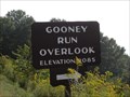 view gallery view galleryW6.4 km |  Gooney Run - Shenandoah Skyline Drive, VA Gooney Run - Shenandoah Skyline Drive, VA
in Elevation Signs Gooney Run Overlook on the Shenandoah Valley Skyline Drive in Virginia. Elevation 2085. posted by: Lat34North location: Virginia date approved: 09/14/2007 last visited: 05/28/2014 |
 view gallery view galleryW6.4 km |  Shenandoah National Park - Linden, Virginia Shenandoah National Park - Linden, Virginia
in 3D Map Models of Our World and Beyond Located within the Dickey Ridge Visitor Center within the Shenandoah National Park. posted by: flyingmoose location: Virginia date approved: 12/23/2022 last visited: never |
 view gallery view galleryW6.4 km | The Massanutten - Front Royal VA in U.S. Civil War Sites The high point near the end of the Massanutten is Signal Knob. During the Civil War, Confederate soldiers used Signal Knob as an observation and signal post. posted by: Don.Morfe location: Virginia date approved: 10/06/2020 last visited: 10/01/2021 |
 view gallery view gallery NW7.1 km NW7.1 km
|  Moose Lodge 829 - Front Royal, Virginia Moose Lodge 829 - Front Royal, Virginia
in Moose Lodges and Centers Located on the westbound side of John Marshall Highway east of Front Royal. posted by: flyingmoose location: Virginia date approved: 12/23/2022 last visited: never |
 view gallery view galleryNW7.4 km |  Samuels Public Library - Front Royal, Virginia Samuels Public Library - Front Royal, Virginia
in Outdoor Wind Harps Wind Harp added to the Library Garden. posted by: flyingmoose location: Virginia date approved: 05/04/2024 last visited: never |
 view gallery view galleryNW7.4 km |  Wind Harp Music New to Library Garden - Front Royal, Virginia Wind Harp Music New to Library Garden - Front Royal, Virginia
in News Article Locations Article about a wind harp at the local library. posted by: flyingmoose location: Virginia date approved: 04/10/2024 last visited: never |
 view gallery view galleryNW7.4 km |  The Anguish Of Displacement - Front Royal, Virginia The Anguish Of Displacement - Front Royal, Virginia
in There's a Book About It While the coordinates are for the northern entrance of the Shenandoah National Park, this book is about the park as a whole. posted by: flyingmoose location: Virginia date approved: 01/28/2023 last visited: never |
 view gallery view galleryNW8 km | The Battle of Front Royal: Belle Boyd in Civil War Discovery Trail Sites As the Confederate army advanced on Front Royal, Belle Boyd, a Confederate spy, informed them that the Union force in Front Royal was very small. posted by: La de Boheme location: Virginia date approved: 04/30/2012 last visited: 07/24/2020 |
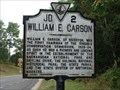 view gallery view galleryNW8.2 km | William E. Carson in Virginia Historical Markers Located on Highway US340 just outside of Front Royal. posted by: MNSearchers location: Virginia date approved: 09/06/2008 last visited: 07/24/2020 |
 view gallery view galleryNW8.2 km |  Skyline Diner - Sunday Strip - Front Royal, VA Skyline Diner - Sunday Strip - Front Royal, VA
in Zippy the Pinhead Locations A diner provides the bookend panels for a joke about a big thumb sculpture using a Casablanca line. posted by: vhasler location: Virginia date approved: 09/10/2011 last visited: never |
 view gallery view galleryNW8.5 km | Front Royal-Battle of Front Royal - Front Royal VA in U.S. Civil War Sites On May 23, 1862, Front Royal was occupied by 1000 Federal troops (1st Maryland Infantry, 29th Pennsylvania and a battery of Knap’s Artillery) under the command of Col. J. R. Kenley. posted by: Don.Morfe location: Virginia date approved: 06/21/2023 last visited: 06/21/2023 |
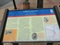 view gallery view galleryNW8.5 km |  Front Royal-Battle of Front Royal - Front Royal VA Front Royal-Battle of Front Royal - Front Royal VA
in Signs of History This marker is in front of the Front Royal Visitor Center on East Main Street. posted by: Don.Morfe location: Virginia date approved: 07/19/2023 last visited: 07/19/2023 |
 view gallery view galleryNW8.5 km |  Battle of Front Royal - Front Royal VA Battle of Front Royal - Front Royal VA
in Battlefields On May 23, 1862, Front Royal was occupied by 1000 Federal troops (1st Maryland Infantry, 29th Pennsylvania and a battery of Knap’s Artillery) under the command of Col. J. R. Kenley. posted by: Don.Morfe location: Virginia date approved: 11/08/2020 last visited: 10/17/2021 |
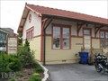 view gallery view galleryNW8.5 km |  Front Royal - Warren County Visitors Center Front Royal - Warren County Visitors Center
in Tourist Information Centers - Visitor Centers Located between the Blue Ridge Mountains and Shenandoah River in Virginia, the Visitor Center provides information about attractions and activities in Front Royal and Warren County. posted by: La de Boheme location: Virginia date approved: 05/07/2012 last visited: 07/19/2023 |
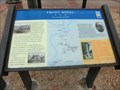 view gallery view galleryNW8.5 km | Front Royal-Crossroads of War - Front Royal VA in U.S. Civil War Sites During the Civil War, Front Royal, a “cross-roads town” of fewer than 600 residents, was the economic center of Warren County. One soldier described the town as “...quite rural. posted by: Don.Morfe location: Virginia date approved: 06/21/2023 last visited: 06/21/2023 |
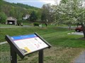
 view gallery view galleryNW8.5 km |  You Are Here Maps-Front Royal-Crossroads of War - Front Royal VA You Are Here Maps-Front Royal-Crossroads of War - Front Royal VA
in 'You Are Here' Maps The You Are Here Map shows that you are at Visitor Center on E. Main Street, Front Royal, VA posted by: Don.Morfe location: Virginia date approved: 07/19/2023 last visited: 07/19/2023 |
 view gallery view galleryNW8.5 km | Front Royal-Crossroads of War - Front Royal VA in Signs of History During the Civil War, Front Royal, a “cross-roads town” of fewer than 600 residents, was the economic center of Warren County. One soldier described the town as “...quite rural. posted by: Don.Morfe location: Virginia date approved: 07/19/2023 last visited: 07/19/2023 |
|