 view gallery view gallery N3.5 km N3.5 km
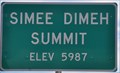
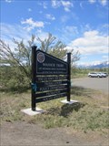
|   Simee Dimeh Summit ~ Elevation 5987 Feet Simee Dimeh Summit ~ Elevation 5987 Feet
in Elevation Signs This Elevation Sign sits atop Simee Dimeh Summit on US Highway 395 between Gardnerville and the Nevada/California Border. posted by:  brwhiz brwhiz location: Nevada date approved: 09/19/2012 last visited: never |
 view gallery view gallery S11.1 km S11.1 km
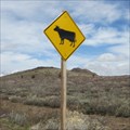
|  Cow Crossing - Mono County, CA Cow Crossing - Mono County, CA
in Uncommon Crossing Signs This cow crossing is on Hway 89 in Mono County, CA. It's at the Mono/Alpine county borders. posted by: saopaulo1 location: California date approved: 05/23/2011 last visited: never |
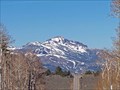
 view gallery view galleryS11.4 km |  Monitor Pass, California Monitor Pass, California
in Named Mountain Gaps Monitor pass is the Sierra Nevada mountains. posted by: Geojeepsters location: California date approved: 08/05/2024 last visited: never |
 view gallery view galleryS11.4 km | Monitor Pass, CA - 8,314 ft in Elevation Signs One of the highest passes across the Sierra Nevada posted by:  Bernd das Brot Team Bernd das Brot Team location: California date approved: 05/31/2008 last visited: 07/28/2024 |
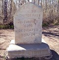
 view gallery view galleryS11.4 km |  Ebbetts Pass Scenic Byway - Monitor Pass Ebbetts Pass Scenic Byway - Monitor Pass
in National Scenic Byways The eastern entrance to Ebbetts Pass Scenic Byway posted by: Bernd das Brot Team location: California date approved: 05/31/2008 last visited: 07/28/2024 |
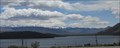 view gallery view gallery SE11.6 km SE11.6 km
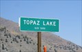
|  Topaz Lake Topaz Lake
in Wikipedia Entries Topaz Lake is a resevoir that straddles the states of California and Nevada. posted by: saopaulo1 location: Nevada date approved: 06/09/2011 last visited: 09/24/2011 |
 view gallery view galleryS11.6 km | Monitor Pass in Wikipedia Entries Monitor Pass is one of the highest points in the Sierras. posted by: saopaulo1 location: California date approved: 05/17/2011 last visited: 07/28/2024 |
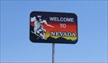 view gallery view gallerySE11.7 km |  CA/NV 395 North CA/NV 395 North
in Border Crossings Welcome to Nevada. When heading north on 395 in California, you cross the border near Topaz Lake. posted by: Free2bme29 location: Nevada date approved: 07/15/2009 last visited: 07/12/2012 |
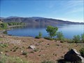 view gallery view gallerySE13.4 km | Eastern Sierra Scenic Byway - Topaz Lake, CA in National Scenic Byways Lake along US Hwy 395 posted by: Bernd das Brot Team location: California date approved: 05/20/2008 last visited: 09/24/2011 |
 view gallery view gallerySE13.7 km | Topaz Lake, CA - 5050 Feet in Elevation Signs There's a pull-out on the road where you can stop and look at the lake while getting this waymark! posted by: Free2bme29 location: California date approved: 07/06/2009 last visited: 09/14/2021 |
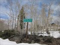
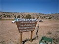 view gallery view galleryN15.1 km |  Pinenut Nut Mountains - Gardnerville Nevada Pinenut Nut Mountains - Gardnerville Nevada
in Public Access Lands This land is managed by the Bureau of Land Management. posted by: Geojeepsters location: Nevada date approved: 07/30/2012 last visited: never |
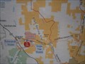 view gallery view galleryN15.1 km |  You are Here - Pinenut Mountains Nevada You are Here - Pinenut Mountains Nevada
in 'You Are Here' Maps You are here map on the Pinenut Mountain Public land. posted by: Geojeepsters location: Nevada date approved: 07/30/2012 last visited: never |
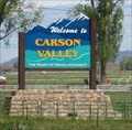 view gallery view gallery NW15.4 km NW15.4 km
|  Carson Valley, NV - "The heart of Douglas County" Carson Valley, NV - "The heart of Douglas County"
in Welcome Signs A sign just outside of Gardnerville welcoming visitors to the Carson Valley. posted by: saopaulo1 location: Nevada date approved: 05/29/2011 last visited: never |
 view gallery view galleryNW15.9 km |  Dresslerville - Dresslerville, NV Dresslerville - Dresslerville, NV
in Nevada Historical Markers A plaque for the community of Dresslerville. posted by: saopaulo1 location: Nevada date approved: 05/21/2011 last visited: 10/16/2010 |
 view gallery view galleryNW16.1 km | CA / NV on Highway 88 - south of Carson City, NV in Border Crossings This is the border crossing on Highway 88 between California and Nevada in the United States. posted by: Chasing Blue Sky location: California date approved: 03/08/2012 last visited: 10/09/2016 |
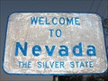 view gallery view galleryNW16.1 km | The Silver State - Nevada, USA in Welcome Signs This is the welcome sign at the border of California and Nevada, on Highway 88, in the United States. posted by: Chasing Blue Sky location: Nevada date approved: 03/07/2012 last visited: 10/09/2016 |
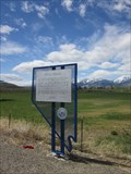
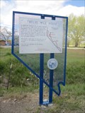 view gallery view galleryNW16.1 km | Twelve Mile House - Gardnerville, NV in Nevada Historical Markers A plaque about the Twelve Mile House. This plaque is located along Hway 395. posted by: saopaulo1 location: Nevada date approved: 05/21/2011 last visited: 10/16/2010 |
 view gallery view galleryNW16.1 km |  Washoe Tribe Police Department - Gardnerville, NV Washoe Tribe Police Department - Gardnerville, NV
in Police Stations The Police department for the Washoe Tribe of Nevada and California. The building is located outside of Gardnerville, NV. posted by: saopaulo1 location: Nevada date approved: 05/17/2011 last visited: never |
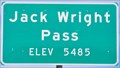 view gallery view gallery E16.4 km E16.4 km
| Jack Wright Pass ~ Elevation 5485 Feet in Elevation Signs This Elevation Sign is located at the top of Jack Wright Pass on Nevada Highway 208 west of Wellington, Nevada. posted by: brwhiz location: Nevada date approved: 09/21/2012 last visited: never |
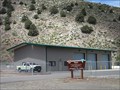 view gallery view gallerySE16.9 km |  Topaz Interagency Fire Control Station Topaz Interagency Fire Control Station
in Firehouses The Topz Interagency Fire Control Station is located in Topaz, CA. It's run by the USDA and BLM. posted by: saopaulo1 location: California date approved: 05/17/2011 last visited: never |
 view gallery view gallery SW17.1 km SW17.1 km
|  Marklee's Cabin Site - Markleeville, CA Marklee's Cabin Site - Markleeville, CA
in California Historical Markers The Marklee's Cabin Site is located where the county courthouse is located. posted by: saopaulo1 location: California date approved: 05/21/2011 last visited: never |
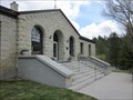
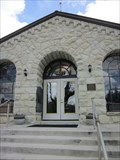 view gallery view gallerySW17.1 km |  Alpine County Courthouse - Markleeville, CA Alpine County Courthouse - Markleeville, CA
in Courthouses The Alpine County courthouse is located in the county seat of Markleeville. posted by: saopaulo1 location: California date approved: 05/17/2011 last visited: never |
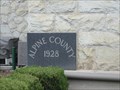 view gallery view gallerySW17.1 km |  1928 - Alpine County Courthouse - Markleeville, CA 1928 - Alpine County Courthouse - Markleeville, CA
in Dated Buildings and Cornerstones A cornerstone on the county courthouse. posted by: saopaulo1 location: California date approved: 05/19/2011 last visited: never |
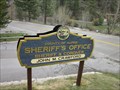 view gallery view gallerySW17.1 km | Alpine County Sheriff- Markleeville, CA in Police Stations The Alpine County Sheriff's headquarters is located in the county courthouse on Hway 89 in Markleeville, CA. posted by: saopaulo1 location: California date approved: 05/17/2011 last visited: never |
 view gallery view gallerySW17.1 km | Alpine County Courthouse - Markleeville, CA in Wikipedia Entries The Alpine County Courthouse is in the county seat of Markleeville, CA. posted by: saopaulo1 location: California date approved: 06/08/2011 last visited: never |
|