 view gallery view gallery NW0.3 km NW0.3 km
|   Shenandoah Caverns, VA 22847 Shenandoah Caverns, VA 22847
in U.S. Post Offices 22847 is ZIP Code for both Quicksburg, VA and Shenandoah Caverns. The Shenandoah Caverns PO is located in the store that serves as the entrance to the actual caverns. There is also a Quicksburg post office on Ridge Road that is more traditional. posted by:  SportsPhotoGuy SportsPhotoGuy location: Virginia date approved: 06/27/2010 last visited: 04/22/2024 |
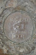 view gallery view galleryNW0.3 km |  413 U.S.E.D. - Shenandoah Caverns, VA 413 U.S.E.D. - Shenandoah Caverns, VA
in U.S. Benchmarks A bronze disk placed on a rock formation inside Shenandoah Caverns. posted by:  Ernmark Ernmark location: Virginia date approved: 09/03/2011 last visited: never |
 view gallery view galleryNW0.3 km | ") Shenandoah Caverns - New Market, VA Shenandoah Caverns - New Market, VA
in Cave Entrances (Natural) Popular cave for tourists located just between New Market & Mt. Jackson, VA. posted by: Ernmark location: Virginia date approved: 08/08/2011 last visited: 04/22/2024 |
 view gallery view gallery NE1.3 km NE1.3 km
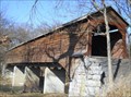
|  Meems Bottom Covered Bridge - Mt. Jackson, VA Meems Bottom Covered Bridge - Mt. Jackson, VA
in U.S. National Register of Historic Places The 204-foot covered bridge is the longest remaining in Virginia. posted by: vhasler location: Virginia date approved: 03/03/2012 last visited: 04/22/2024 |
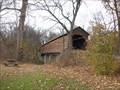 view gallery view galleryNE1.3 km |  Meem's Bottom Covered Bridge Meem's Bottom Covered Bridge
in Covered Bridges The Meem's Bottom Covered Bridge is located on Wissler Road, about 2/10th of a mile west of U. S. Route 11 in Shenandoah County, Virginia. posted by: Sneakin Deacon location: Virginia date approved: 12/16/2006 last visited: 04/22/2024 |
 view gallery view gallery SE1.4 km SE1.4 km
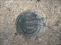
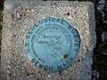
| P 340 Reset 1985 in U.S. Benchmarks P 340 Reset 1985 in Shenandoah County VA posted by: slippeddisk location: Virginia date approved: 11/29/2008 last visited: never |
 view gallery view gallery E1.8 km E1.8 km
|  Meem's Bottom Covered Bridge Meem's Bottom Covered Bridge
in Virginia Historical Markers This historic marker is located on U. S. Route 11 in Shenandoah County, Virginia posted by: Sneakin Deacon location: Virginia date approved: 12/16/2006 last visited: 04/22/2024 |
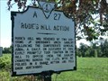
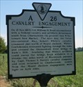
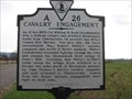 view gallery view gallerySE1.9 km | Cavalry Engagement in Virginia Historical Markers This historic marker stands on U. S. Route 11 north of New Market, Virginia posted by: Sneakin Deacon location: Virginia date approved: 12/16/2006 last visited: 07/05/2023 |
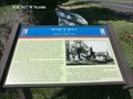
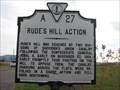 view gallery view gallerySE1.9 km | Rude's Hill Action in Virginia Historical Markers This historic marker is located on Route 11, north of New Market, Virginia. posted by: Sneakin Deacon location: Virginia date approved: 12/16/2006 last visited: 07/05/2023 |
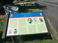
 view gallery view gallerySE1.9 km |  Rude's Hill-Jackson at Rude’s Hill - New Market VA Rude's Hill-Jackson at Rude’s Hill - New Market VA
in Civil War Discovery Trail Sites Gen. Thomas J. “Stonewall” Jackson’s small Confederate force went into a defensive position here after retiring from the battle at Kernstown. posted by: Don.Morfe location: Virginia date approved: 07/05/2020 last visited: 10/05/2021 |
 view gallery view gallerySE1.9 km | Rude’s Hill-Knoll of Refuge and Attack - New Market VA in Civil War Discovery Trail Sites The spring of 1864 opened with United States forces pressing Confederate armies defending fronts scattered throughout the Confederacy. Union Gen. Franz Sigel was assigned the task of securing the Shenandoah Valley. posted by: Don.Morfe location: Virginia date approved: 07/20/2020 last visited: 10/05/2021 |
 view gallery view gallerySE1.9 km | Rude’s Hill - New Market VA in American Civil War Monuments and Memorials Stonewall Jackson’s camp ground April 2–16, 1862; his headquarters at the foot of this hill. posted by: Don.Morfe location: Virginia date approved: 07/23/2020 last visited: 07/05/2023 |
 view gallery view gallerySE1.9 km | Rude's Hill-Jackson at Rude’s Hill - New Market VA in U.S. Civil War Sites This old house photographed during the early 20th century and still standing about 600 yards north on the west side of the Valley Pike, was occupied at the beginning of the Civil War by a Lutheran minister, Rev. Anders R. Rude. posted by: Don.Morfe location: Virginia date approved: 06/25/2023 last visited: 06/25/2023 |
 view gallery view gallerySE1.9 km |  Rude’s Hill Action - New Market Rude’s Hill Action - New Market
in Battlefields Marker is near New Market, Virginia, in Shenandoah County. Marker is on Old Valley Pike (U.S. 11) south of Caverns Road at Exit 269 (Interstate 81). New Market VA 22844 posted by: Don.Morfe location: Virginia date approved: 07/04/2023 last visited: 07/04/2023 |
 view gallery view gallerySE1.9 km | Rude’s Hill-Knoll of Refuge and Attack - New Market VA in U.S. Civil War Sites On the last day of April 1864, Sigel, with 9,000 men and 28 guns, marched south from Martinsburg. By May 11, Sigel’s advance ran into Confederates posted at Rude’s Hill under the command of a Maryland Confederate, Capt. T. Sturgis Davis. posted by: Don.Morfe location: Virginia date approved: 06/25/2023 last visited: 06/25/2023 |
 view gallery view gallerySE1.9 km | Cavalry Engagement - New Market VA in Battlefields Marker is near New Market, Virginia, in Shenandoah County. Marker is on Old Valley Pike (U.S. 11) near Caverns Road at Exit 269 (Interstate 81).
New Market VA 22844 posted by: Don.Morfe location: Virginia date approved: 07/04/2023 last visited: 07/04/2023 |
 view gallery view gallerySE1.9 km | Cavalry Engagement - New Market VA in American Civil War Monuments and Memorials Marker is near New Market, Virginia, in Shenandoah County. Marker is on Old Valley Pike (U.S. 11) near Caverns Road at Exit 269 (Interstate 81). New Market VA 22844 posted by: Don.Morfe location: Virginia date approved: 07/08/2023 last visited: 07/08/2023 |
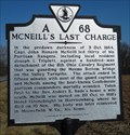 view gallery view galleryNE2.6 km | McNeill’s Last Charge in Virginia Historical Markers Description of final battle for Capt. John Hanson McNeill, Confederate Ranger posted by: vhasler location: Virginia date approved: 02/15/2012 last visited: 07/24/2020 |
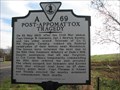 view gallery view gallerySE2.7 km | Post Appomattox Tragedy in Virginia Historical Markers This historic marker is located on U. S. Route 11 in Shenandoah County, Virginia posted by: Sneakin Deacon location: Virginia date approved: 12/20/2006 last visited: 07/24/2020 |
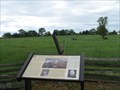
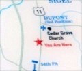 view gallery view gallerySE2.7 km |  'You Are Here' Maps-DuPont at Rude’s Hill - New Market VA 'You Are Here' Maps-DuPont at Rude’s Hill - New Market VA
in 'You Are Here' Maps 'You Are Here' Map shows that you are on Route U.S. 11, Old Valley Pike,
New Market, VA USA 22844. posted by: Don.Morfe location: Virginia date approved: 10/13/2023 last visited: 10/13/2023 |
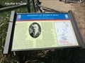 view gallery view gallerySE2.7 km | DuPont at Rude’s Hill “I had to depend entirely upon myself ... ” - New Market VA in Civil War Discovery Trail Sites Here Capt. Henry DuPont, commanding B Battery, 5th U.S. Artillery, protected Union Gen. Franz Sigel’s defeated army as it retreated after the Battle of New Market on May 15, 1864. posted by: Don.Morfe location: Virginia date approved: 07/20/2020 last visited: 10/05/2021 |
 view gallery view galleryNE2.9 km | TT 36 T 1932 in U.S. Benchmarks TT 36 T 1932 Shenandoah County VA posted by: slippeddisk location: Virginia date approved: 12/09/2008 last visited: 01/11/2012 |
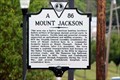 view gallery view galleryNE4.5 km | Mount Jackson in Virginia Historical Markers This town along the Old Valley Pike was named for Andrew Jackson. posted by: Markerman62 location: Virginia date approved: 08/14/2020 last visited: 08/05/2020 |
 view gallery view galleryNE5 km |  Mount Jackson Apple Basket Water Tower Mount Jackson Apple Basket Water Tower
in Water Towers Mount Jackson Apple Basket Water Tower posted by: papermanone & catlover location: Virginia date approved: 08/07/2006 last visited: 02/14/2022 |
 view gallery view gallery S5.1 km S5.1 km
| New Market Battlefield State Historical Park and Hall of Valor Museum: Captain DuPont & Sergeant Burns in Civil War Discovery Trail Sites Two Union soldiers were heroes during the Federal retreat at the Battle of New Market. posted by: La de Boheme location: Virginia date approved: 05/21/2011 last visited: 07/17/2011 |
|