 view gallery view gallery N0.3 km N0.3 km
|   Candy Mountain Express Northern Trailhead Candy Mountain Express Northern Trailhead
in Rails to Trails This Trailhead for the Candy Mountain Express Rail to Trails path is located at Sevier Junction, where US Highway 89 and Utah Highway 70 meet on the north side of the very small community of Sevier, Utah. posted by:  brwhiz brwhiz location: Utah date approved: 03/22/2013 last visited: never |
 view gallery view galleryN0.3 km |  Candy Mountain Express Northern Trailhead Candy Mountain Express Northern Trailhead
in Hiking and walking trailheads This Trailhead for the Candy Mountain Express biking/hiking trail is located at Sevier Junction, where US Highway 89 and Utah Highway 70 meet on the north side of the very small community of Sevier, Utah. posted by: brwhiz location: Utah date approved: 03/22/2013 last visited: never |
 view gallery view gallery NE5.3 km NE5.3 km
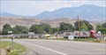
|  Diamond D Travel Plaza Diamond D Travel Plaza
in Truck Stops This Truck Stop is located just east of the Interstate Highway 70 Exit 25 interchange on the west side of Joseph, Utah. posted by: brwhiz location: Utah date approved: 03/13/2013 last visited: never |
 view gallery view galleryNE5.6 km |  Old Church Bell Old Church Bell
in Bells This Bell is mounted on top of a brick monument in front of the Old Church Vacation Rental at the northeast corner of State Street and 100 North in Joseph, Utah. posted by: brwhiz location: Utah date approved: 03/13/2013 last visited: never |
 view gallery view galleryNE5.6 km |  1929 - Old Church Vacation Rental ~ Elsinore, Utah 1929 - Old Church Vacation Rental ~ Elsinore, Utah
in Dated Buildings and Cornerstones This Cornerstone is part of the Old Church Vacation Rental at the northeast corner of State Street and 100 North in Joseph, Utah. posted by: brwhiz location: Utah date approved: 03/13/2013 last visited: never |
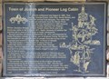
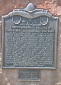
 view gallery view galleryNE5.8 km |  Town of Joseph, Utah and Pioneer Log Cabin ~ USA Town of Joseph, Utah and Pioneer Log Cabin ~ USA
in Human Migration Monuments It took three tries before a permanent settlement was established for Joseph City, Utah, named after a son of Church President Brigham Young. posted by: brwhiz location: Utah date approved: 11/15/2012 last visited: never |
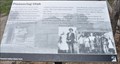
 view gallery view galleryNE5.8 km |  Town of Joseph and Pioneer Log Cabin ~ 478 Town of Joseph and Pioneer Log Cabin ~ 478
in D.U.P. Historic Markers This Daughters of Utah Pioneers Historical Marker is mounted on a brick monument in the park at about 135 N 100 East in Joseph, Utah. posted by: brwhiz location: Utah date approved: 11/17/2012 last visited: never |
 view gallery view galleryNE5.8 km |  First LDS Church Leaders in Joseph First LDS Church Leaders in Joseph
in First of its Kind The first leaders of The Church of Jesus Christ of Latter-day Saints in Joseph were James Hale, George Wilson, and Iver Isaacson. posted by: brwhiz location: Utah date approved: 11/14/2012 last visited: never |
 view gallery view galleryNE5.8 km | First Schoolteacher in Joseph in First of its Kind Mary Farnsworth was the first schoolteacher in Joseph, Utah. posted by: brwhiz location: Utah date approved: 11/14/2012 last visited: never |
 view gallery view galleryNE5.8 km |  Town of Joseph and Pioneer Log Cabin Town of Joseph and Pioneer Log Cabin
in Utah Historical Markers This Daughters of Utah Pioneers Historical Marker is mounted on a brick monument at in the park at about 135 N 100 East in Joseph, Utah. posted by: brwhiz location: Utah date approved: 11/15/2012 last visited: never |
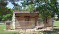 view gallery view galleryNE5.8 km |  David Giles Log Cabin ~ Joseph, Utah David Giles Log Cabin ~ Joseph, Utah
in Relocated Structures This log cabin was relocated from the original 1881 homestead of David Giles on the east bank of the Sevier River to its present location in the center of Joseph, Utah. posted by: brwhiz location: Utah date approved: 11/18/2012 last visited: never |
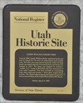
 view gallery view gallery W5.8 km W5.8 km
| Pioneering Utah in Utah Historical Markers This Historical Marker is located on the south side of Clear Creek Canyon Road, just west of Sam Stowe Canyon Road and about 0.6 miles east of the Fremont Indian State Park Visitor Center near Sevier, Utah. posted by: brwhiz location: Utah date approved: 03/13/2013 last visited: never |
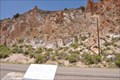 view gallery view galleryW6 km |  The Arch of Art The Arch of Art
in Pictographs These Pictographs are located on the north side of Clear Creek Canyon Road, a short distance east of Fremont Indian State Park Museum and Visitor Center between Sevier and Marysvale, Utah. posted by: brwhiz location: Utah date approved: 03/25/2013 last visited: never |
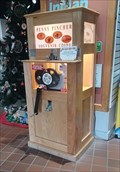 view gallery view galleryW6.8 km |  Freemont Indian State Park Penny Smasher - Sevier, UT Freemont Indian State Park Penny Smasher - Sevier, UT
in Penny Smashers This Penny Smasher is just inside the entrance of the Freemont Indian State Park Visitors Center - in Sevier, Utah. posted by: The Snowdog location: Utah date approved: 01/04/2023 last visited: never |
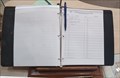 view gallery view galleryW6.8 km |  Freemont Indian State Park Guest Book - Sevier, UT Freemont Indian State Park Guest Book - Sevier, UT
in Guest Books The guest book for Freemont Indian State Park is at the desk in the Visitors Center - in Sevier, Utah. posted by: The Snowdog location: Utah date approved: 01/03/2023 last visited: never |
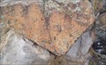 view gallery view galleryW6.8 km | Freemont Indian Pictographs - Freemont Indian State Park, Sevier, UT in Pictographs This Freemont Indian pictorgaph is on displahy outside the Visitors Center of Freemont Indian State Park - in Sevier, Utah. posted by: The Snowdog location: Utah date approved: 01/28/2023 last visited: never |
 view gallery view galleryW6.8 km |  You Are Here - Court of Ceremonies Trail - Sevier, UT You Are Here - Court of Ceremonies Trail - Sevier, UT
in 'You Are Here' Maps This You-Are-Here map is your guide to the trails of Freemont Indian State Park - in Sevier, Utah. posted by: The Snowdog location: Utah date approved: 01/03/2023 last visited: never |
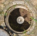
 view gallery view galleryNE6.9 km |  JO0016 ~ J 31 JO0016 ~ J 31
in U.S. Benchmarks This USC&GS Benchmark is located on the south side of Utah Highway 118 about 4.7 miles north of Sevier, Utah. posted by: brwhiz location: Utah date approved: 01/22/2013 last visited: never |
 view gallery view galleryW7.7 km |  Fremont Indian State Park - Utah Fremont Indian State Park - Utah
in State/Provincial Parks Fremont Indian State Park is located at 3820 W Clear Creek Canyon Road near Sevier, Utah. posted by: brwhiz location: Utah date approved: 04/09/2013 last visited: 01/03/2023 |
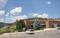 view gallery view galleryW7.7 km |  Fremont Indian State Park Visitor Center Fremont Indian State Park Visitor Center
in Ranger Stations This Ranger Station is located at 3820 W Clear Creek Canyon Road near Sevier, Utah. posted by: brwhiz location: Utah date approved: 03/13/2013 last visited: 01/03/2023 |
 view gallery view galleryNE9.2 km | Joseph William Parker Farm in Utah Historical Markers This Utah Historical Marker is mounted on the front of a house on the north side of the Sevier Highway about 2 miles northeast of Joseph, Utah. posted by: brwhiz location: Utah date approved: 01/18/2013 last visited: never |
 view gallery view galleryNE12.2 km | AA3697 ~ MONROE in U.S. Benchmarks This USC&GS Benchmark is located on the north side of Monroe City Park, just south of the fence and a red fiberglass witness post, in Monroe, Utah. posted by: brwhiz location: Utah date approved: 01/22/2013 last visited: never |
 view gallery view galleryNE12.9 km | Fort Alma (Later Monroe) 1864-1867 ~ 21 in Utah Historical Markers This Daughters of Utah Pioneers Historical Marker is mounted on a dressed-stone monument at the northwest corner of the intersection of 100 West and 200 North in Monroe, Utah. posted by: brwhiz location: Utah date approved: 11/15/2012 last visited: never |
 view gallery view galleryNE12.9 km | Fort Alma (Later Monroe) 1864-1867 ~ 21 in D.U.P. Historic Markers This Daughters of Utah Pioneers Historical Marker is mounted on a dressed-stone monument at the northwest corner of the intersection of 100 West and 200 North in Monroe, Utah. posted by: brwhiz location: Utah date approved: 11/17/2012 last visited: never |
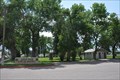 view gallery view galleryNE12.9 km |  Lions Park ~ Monroe, Utah Lions Park ~ Monroe, Utah
in Municipal Parks and Plazas This Municipal Park is located at the southwest corner of Main Street and 100 North in Monroe, Utah. posted by: brwhiz location: Utah date approved: 03/14/2013 last visited: never |
|