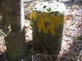
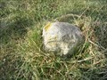
 view gallery view gallery E8 km E8 km
|   MASDIX Tangent Line Mile 8, 1765, Delaware-Maryland MASDIX Tangent Line Mile 8, 1765, Delaware-Maryland
in U.S. Historic Survey Stones and Monuments MASDIX Tangent Line Mile 8, 1765, DE-MD, is a dressed Portland Stone shaft set by Mason and Dixon in 1765 to demarcate the boundary between DE and MD posted by:  seventhings seventhings location: Delaware date approved: 04/26/2009 last visited: never |
 view gallery view galleryE8.2 km | MASDIX Tangent Line Mile 9, 1765, Delaware - Maryland in U.S. Historic Survey Stones and Monuments MASDIX Tangent Line Mile 9, 1765, DE-MD, is a dressed Portland Stone shaft set by Mason and Dixon in 1765 to demarcate the boundary between DE and MD. posted by: seventhings location: Delaware date approved: 10/03/2007 last visited: never |
 view gallery view galleryE8.9 km | MASDIX Tangent Line Mile 6, 1765, Delaware - Maryland in U.S. Historic Survey Stones and Monuments MASDIX Tangent Line Mile 6, 1765, DE-MD, is a dressed Portland Stone shaft set by Mason and Dixon in 1765 to demarcate the boundary between DE and MD. posted by: seventhings location: Delaware date approved: 10/03/2007 last visited: never |
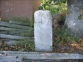
 view gallery view gallery S10.1 km S10.1 km
|  Unnacokossimmon-Emperor to the Indians - Vienna MD Unnacokossimmon-Emperor to the Indians - Vienna MD
in Civil Rights Memorials Unnacokossimmon Emperor to the Indians-Lived (about 1677) at Chicacone, an ancient Indian town north of this point. posted by: Don.Morfe location: Maryland date approved: 10/15/2022 last visited: 10/14/2022 |
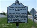 view gallery view galleryS10.1 km |  Unnacokossimmon Unnacokossimmon
in Maryland Historical Markers Unnacokossimmon Emperor to the Indians-Unnacokossimmon Emperor to the Indians- posted by: Don.Morfe location: Maryland date approved: 10/29/2019 last visited: 09/28/2021 |
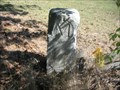
 view gallery view gallery NE10.1 km NE10.1 km
| MASDIX Tangent Line Mile 12, 1765 & 1976, Delaware - Maryland in U.S. Historic Survey Stones and Monuments MASDIX Tangent Line Mile 12, 1765 & 1976, DE-MD, is a dressed Portland Stone shaft set by Mason and Dixon in 1765 to demarcate the boundary between DE and MD posted by: seventhings location: Delaware date approved: 04/11/2007 last visited: never |
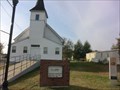
 view gallery view gallery W10.6 km W10.6 km
|  Faith Community UMC Church-Living a Double Life - East New Market, MD Faith Community UMC Church-Living a Double Life - East New Market, MD
in Underground Railroad Sites During the 1840s and 1850s, the locals knew Reverend Samuel Green as a literate, highly respected Methodist Episcopal preacher and community leader. posted by: Don.Morfe location: Maryland date approved: 02/11/2020 last visited: 10/28/2021 |
 view gallery view galleryW10.6 km | Faith Community UMC Church-Living a Double Life - East New Market, MD in Civil Rights Memorials Unknown to many, Rev. Green had a second life. For years, he served as an Underground Railroad agent, secretly aiding Harriet Tubman and freedom-seeking refugees. posted by: Don.Morfe location: Maryland date approved: 10/04/2022 last visited: 10/04/2022 |
 view gallery view galleryW10.6 km |  Faith Community United Methodist Church - East New Market MD Faith Community United Methodist Church - East New Market MD
in Methodist Churches Now known as Faith Community United Methodist Church, this church
is the second structure to house this still-active congregation.
African-Americans regarded southern white ministers as part of the system of slavery. posted by: Don.Morfe location: Maryland date approved: 10/04/2022 last visited: 10/04/2022 |
 view gallery view galleryW10.6 km |  Faith Community UMC Church-Living a Double Life - East New Market, MD Faith Community UMC Church-Living a Double Life - East New Market, MD
in Signs of History During the 1840s and 1850s, the locals knew Reverend Samuel Green as a literate, highly respected Methodist Episcopal preacher and community leader. posted by: Don.Morfe location: Maryland date approved: 10/04/2022 last visited: 10/04/2022 |
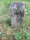 view gallery view gallery SE10.6 km SE10.6 km
| MASDIX Tangent Line Mile 4, 1765, Delaware - Maryland in U.S. Historic Survey Stones and Monuments MASDIX Tangent Line Mile 4, 1765, DE-MD, is a dressed Portland Stone shaft set by Mason and Dixon in 1765 to demarcate the boundary between DE and MD. posted by: seventhings location: Delaware date approved: 05/20/2008 last visited: never |
 view gallery view galleryNE11.1 km | MASDIX Tangent Line Mile 13, 1765, Delaware-Maryland in U.S. Historic Survey Stones and Monuments MASDIX Tangent Line Mile 13, 1765, DE-MD, is a dressed Portland Stone shaft set by Mason and Dixon in 1765 to demarcate the boundary between DE and MD posted by: seventhings location: Delaware date approved: 04/26/2009 last visited: never |
 view gallery view gallerySE11.7 km | MASDIX Tangent Line Mile 3, 1765, Delaware - Maryland in U.S. Historic Survey Stones and Monuments MASDIX Tangent Line Mile 3, 1765, DE-MD, is a dressed Portland Stone shaft set by Mason and Dixon in 1765 to demarcate the boundary between DE and MD. posted by: seventhings location: Delaware date approved: 05/20/2008 last visited: never |
 view gallery view galleryNE12.2 km | MASDIX Tangent Line Mile 14, 1765, Delaware-Maryland in U.S. Historic Survey Stones and Monuments MASDIX Tangent Line Mile 14, 1765, DE-MD, is a dressed Portland Stone shaft set by Mason and Dixon in 1765 to demarcate the boundary between DE and MD. posted by: seventhings location: Delaware date approved: 10/24/2006 last visited: 10/24/2006 |
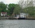 view gallery view galleryE12.4 km |  Woodland Ferry Woodland Ferry
in Ferries and Ferry Landings A colonial, operating cable ferry across the Nanticoke River. posted by:  ivorybilledbirder ivorybilledbirder location: Delaware date approved: 01/04/2014 last visited: 05/18/2021 |
 view gallery view galleryE12.4 km |  Woodland Ferry (SC-173) - Woodland, DE Woodland Ferry (SC-173) - Woodland, DE
in Delaware Historical Markers 2004 by Delaware Public Archives. Marker Number SC-173. posted by: turnersrugs location: Delaware date approved: 03/05/2013 last visited: never |
 view gallery view galleryE12.7 km |  Woodland School - Seaford, Delaware, USA Woodland School - Seaford, Delaware, USA
in One-Room Schoolhouses This Schoolhouse was relocated to the recently acquired Woodland Park grounds. posted by: ted28285 location: Delaware date approved: 07/13/2023 last visited: 08/01/2023 |
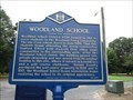 view gallery view galleryE12.7 km | Woodland School (SC-277) - Seaford, Delaware in Delaware Historical Markers This marker tells of a one room schoolhouse. posted by: r.e.s.t.seekers location: Delaware date approved: 07/12/2023 last visited: 07/12/2023 |
 view gallery view gallerySE13 km | MASDIX Tangent Line Mile 2, 1765, Delaware - Maryland in U.S. Historic Survey Stones and Monuments MASDIX Tangent Line Mile 2, 1765, DE-MD, is a dressed Portland Stone shaft set by Mason and Dixon in 1765 to demarcate the boundary between DE and MD. posted by: seventhings location: Delaware date approved: 05/20/2008 last visited: never |
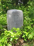
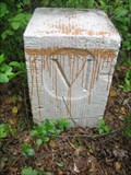
 view gallery view galleryNE13.5 km | OAK GROVE CROWNSTONE (SC-178) - Seaford, DE in Delaware Historical Markers Oak Grove Crownstone, SC-178 posted by: dinobalz location: Delaware date approved: 03/18/2007 last visited: never |
 view gallery view galleryNE13.5 km | MASDIX Tangent Line Mile 15, 1765, Delaware-Maryland in U.S. Historic Survey Stones and Monuments MASDIX Tangent Line Mile 15, 1765, DE-MD, is a dressed Portland Stone shaft set by Mason and Dixon in 1765 to demarcate the boundary between DE and MD. posted by: seventhings location: Delaware date approved: 10/25/2006 last visited: 03/18/2007 |
 view gallery view galleryNE13.5 km | OAK GROVE CORNERSTONE (SC-178) - Seaford, DE in Delaware Historical Markers Location of a stone which marks the southwest corner of the State of Delaware. posted by: GeodeGal location: Delaware date approved: 02/27/2007 last visited: 04/27/2006 |
 view gallery view galleryW13.5 km |  Linkwood-Salem Vol. Fire Co. Station 61 Flagpole - Linkwood, MD Linkwood-Salem Vol. Fire Co. Station 61 Flagpole - Linkwood, MD
in Nautical Flag Poles A nautical flagpole at the Linkwood-Salem Volunteer fire station in Linkwood, Maryland. posted by: bluesnote location: Maryland date approved: 08/10/2021 last visited: never |
 view gallery view galleryW13.5 km |  Linkwood-Salem Vol. Fire Co. Station 61 Linkwood-Salem Vol. Fire Co. Station 61
in Firehouses A volunteer fire station in Linkwood, Maryland. posted by: bluesnote location: Maryland date approved: 08/10/2021 last visited: never |
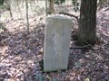
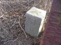
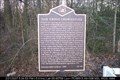
![Image for MASON AND DIXON STONE, [1768] & 1981, Maryland](https://img.geocaching.com/waymarking/small/8a1b7ccf-8901-4ecc-8b45-335532a5475d.jpg) view gallery view galleryS14.2 km |  MASON AND DIXON STONE, [1768] & 1981, Maryland MASON AND DIXON STONE, [1768] & 1981, Maryland
in U.S. Benchmarks MASON AND DIXON STONE, [1768] & 1981, MD, is a dressed Portland Stone shaft that does NOT mark any boundary line. posted by: seventhings location: Maryland date approved: 03/17/2008 last visited: never |
|