 view gallery view gallery S0.5 km S0.5 km
|   Green Bank Observatory - Green Bank, West Virginia Green Bank Observatory - Green Bank, West Virginia
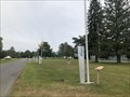
in Solar System Models Located along Observatory Road starting in front of the Visitor Center. posted by:  flyingmoose flyingmoose location: West Virginia date approved: 08/12/2021 last visited: never |
 view gallery view galleryS0.5 km |  Green Bank Observatory - Green Bank, West Virginia Green Bank Observatory - Green Bank, West Virginia
in Astronomical Observatories Located at the intersection of Potomac Highlands Trail and Observatory Road. posted by: flyingmoose location: West Virginia date approved: 08/12/2021 last visited: 06/24/2024 |
 view gallery view galleryS0.5 km |  Green Bank Observatory - Green Bank, West Virginia Green Bank Observatory - Green Bank, West Virginia
in Whispering Galleries Located at the intersection of Potomac Highlands Trail and Observatory Road. posted by: flyingmoose location: West Virginia date approved: 08/13/2021 last visited: never |
 view gallery view galleryS0.5 km |  Reber Radio Telescope - Green Bank, West Virginia Reber Radio Telescope - Green Bank, West Virginia
in U.S. National Register of Historic Places Located at the intersection of Potomac Highlands Trail and Observatory Road. posted by: flyingmoose location: West Virginia date approved: 08/12/2021 last visited: never |
 view gallery view gallery SW2.1 km SW2.1 km
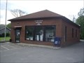
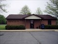
|  Green Bank, WV. 24944 Green Bank, WV. 24944
in U.S. Post Offices Green Bank WV 24944, Post Office posted by: dukemartin location: West Virginia date approved: 05/13/2013 last visited: never |
 view gallery view gallery N6.4 km N6.4 km
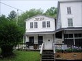
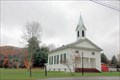
|  Kerr Memorial Church - Boyer, West Virginia Kerr Memorial Church - Boyer, West Virginia
in Country Churches Kerr Memorial is a beautiful old wooden country church set just off of the main highway in a grove of trees at the village of Boyer. posted by:  misfitt misfitt location: West Virginia date approved: 02/07/2008 last visited: never |
 view gallery view gallery W9.2 km W9.2 km
|  Bald Knob, West Virginia Bald Knob, West Virginia
in Scenic Overlooks Not quite at the Summit of Bald Knob, but the observation platform is accessed by the Cass Scenic Railroad, an 11-mile trip up the mountain from the town of Cass. posted by: buffalohiker location: West Virginia date approved: 08/22/2015 last visited: 06/22/2024 |
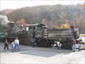 view gallery view gallerySW9.5 km |  Cass Scenic Railroad Cass Scenic Railroad
in Scenic Railroads A well-preserved, state-owned logging railroad in the mountains of West Virginia. posted by: Shorelander location: West Virginia date approved: 12/13/2007 last visited: 06/22/2024 |
 view gallery view gallerySW9.5 km | Cass Station in Train Stations/Depots The southern terminus and station of the Cass Scenic Railroad. posted by: Shorelander location: West Virginia date approved: 12/15/2007 last visited: 06/21/2024 |
 view gallery view gallerySW9.5 km | Cass, WV, 24927 in U.S. Post Offices Cass, West Virginia, 24927, Post Office posted by: dukemartin location: West Virginia date approved: 05/09/2012 last visited: 08/14/2021 |
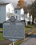 view gallery view gallerySW9.7 km |  Cass Cass
in West Virginia Historical Markers A marker describing Cass, West Virginia. posted by: Shorelander location: West Virginia date approved: 12/13/2007 last visited: 06/21/2024 |
 view gallery view gallerySW9.8 km | Dunmore, WV, 24934 in U.S. Post Offices Dunmore, West Virginia, 24934, Post Office posted by: dukemartin location: West Virginia date approved: 05/09/2012 last visited: never |
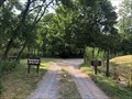 view gallery view gallerySW10.3 km |  Greenbrier River Trail (Northern Terminus) - Cass, West Virginia Greenbrier River Trail (Northern Terminus) - Cass, West Virginia
in Rails to Trails Located off of Back Mountain Road on the west side of Cass. posted by: flyingmoose location: West Virginia date approved: 08/10/2021 last visited: never |
 view gallery view gallerySW10.3 km | Baxter Presbyterian Church - Dunmore, West Virginia. in Country Churches Baxter Presbyterian Church is located on highway 28 in Dunmore just off of highway 92. posted by: misfitt location: West Virginia date approved: 02/07/2008 last visited: never |
 view gallery view gallery NE11.3 km NE11.3 km
|  Battle of Point Pleasant - Point Pleasant WV Battle of Point Pleasant - Point Pleasant WV
in Battlefields West Virginia was long a part of Virginia. Morgan Morgan began the settlement of the region in 1727. A great battle with the Indians took place at Point Pleasant, 1774. West Virginia became a separate state of the union in 1863. posted by: Don.Morfe location: West Virginia date approved: 11/21/2020 last visited: 10/16/2021 |
 view gallery view galleryNE11.3 km |  Highland County Highland County
in Virginia Historical Markers Found on Highway 250. posted by: MNSearchers location: Virginia date approved: 09/06/2008 last visited: 08/14/2021 |
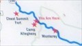 view gallery view galleryNE11.3 km |  'You Are Here' Maps-War In West Virginia-A Decisive Campaign - Bartow WV 'You Are Here' Maps-War In West Virginia-A Decisive Campaign - Bartow WV
in 'You Are Here' Maps The 'You Are Here' Map shows that you are on Mountain Turnpike U.S. 250, Bartow WV posted by: Don.Morfe location: West Virginia date approved: 10/05/2023 last visited: 10/05/2023 |
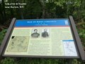 view gallery view galleryNE11.3 km |  War In West Virginia-A Decisive Campaign - Bartow WV War In West Virginia-A Decisive Campaign - Bartow WV
in U.S. Civil War Sites In the spring of 1861, Union forces rushed into northwestern Virginia to secure the vital Baltimore and Ohio Railroad, protect important turnpikes, and support Unionists against Confederates. posted by: Don.Morfe location: West Virginia date approved: 07/01/2023 last visited: 07/01/2023 |
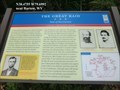 view gallery view galleryNE11.3 km | The Great Raid-Path of Destruction - Bartow WV in U.S. Civil War Sites Imboden’s goals were to destroy Baltimore and Ohio Railroad bridges and trestles, recruit young men for the Confederate army, and attack Union garrisons at Beverly, Philippi, and Buckhannon. Lee approved the plan. posted by: Don.Morfe location: West Virginia date approved: 07/01/2023 last visited: 07/01/2023 |
 view gallery view galleryNE11.3 km | 'You Are Here' Maps-The Great Raid-Path of Destruction - Bartow WV in 'You Are Here' Maps The 'You Are Here' Map shows that you are on Mountain Turnpike, Bartow WV posted by: Don.Morfe location: West Virginia date approved: 10/05/2023 last visited: 10/05/2023 |
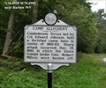 view gallery view galleryNE11.3 km | Battle at Camp Allegheny - Bartow WV in Battlefields Confederate forces led by Col. Edward Johnson held a fortified camp here in winter of 1861-62. Sharp attack occurred, Dec. 13, 1861, in which the Union troops under Gen. Robert Milroy were beaten off. posted by: Don.Morfe location: West Virginia date approved: 11/21/2020 last visited: 08/14/2021 |
 view gallery view galleryNE11.3 km | Camp Allegheny - Bartow WV in American Civil War Monuments and Memorials Marker is located on US 250 (eastbound) at West Virginia/Virginia border Pocahontas County West Virginia. Marker Number: WV130 posted by: Don.Morfe location: West Virginia date approved: 09/01/2023 last visited: 09/01/2023 |
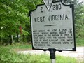
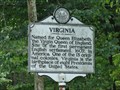 view gallery view galleryNE11.3 km | Virginia in West Virginia Historical Markers Located on highway 250 near Hightown. Located among many other signs. posted by: MNSearchers location: West Virginia date approved: 09/11/2008 last visited: 10/05/2023 |
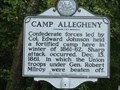 view gallery view galleryNE11.3 km | Camp Allegheny in West Virginia Historical Markers Located along highway 250 near Hightown. posted by: MNSearchers location: West Virginia date approved: 09/11/2008 last visited: 08/14/2021 |
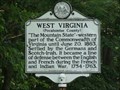 view gallery view galleryNE11.3 km | West Virginia in West Virginia Historical Markers Located on highway 250 near Hightown. posted by: MNSearchers location: West Virginia date approved: 09/11/2008 last visited: 08/14/2021 |
|