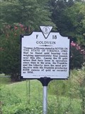
 view gallery view gallery NW4.2 km NW4.2 km
|   Goldvein Goldvein
in Virginia Historical Markers Virginia Historic Highway Marker F-18. "Goldvein" posted by:  garmin_geek garmin_geek location: Virginia date approved: 09/05/2011 last visited: never |
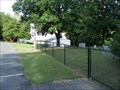
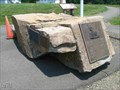 view gallery view galleryNW4.3 km |  Monroe Park - Goldvein VA Monroe Park - Goldvein VA
in Citizen Memorials Plaques mounted on a boulder pay tribute to the contributors of Monroe Park in Fauquier County, VA. posted by: La de Boheme location: Virginia date approved: 06/05/2011 last visited: 05/23/2015 |
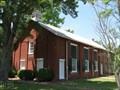
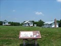 view gallery view galleryNW4.3 km |  Gold Mining Camp Museum - Goldvein VA Gold Mining Camp Museum - Goldvein VA
in History Museums The Gold Mining Camp Museum is the only museum in Virginia dedicated to the history of gold and mining. posted by: La de Boheme location: Virginia date approved: 06/28/2011 last visited: 05/23/2015 |
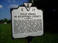 view gallery view gallery E4.8 km E4.8 km
| Gold Mining in Stafford County in Virginia Historical Markers Virginia Highway marker E-17 Gold Mining in Stafford County, posted 1990. posted by: garmin_geek location: Virginia date approved: 05/20/2009 last visited: 09/01/2011 |
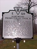 view gallery view galleryE5.1 km | Hartwood Presbyterian Church in Virginia Historical Markers Historic Church still in use. posted by: johnjm99 location: Virginia date approved: 03/05/2006 last visited: 05/20/2010 |
 view gallery view gallery S5.3 km S5.3 km
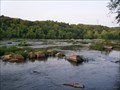
|  CONFLUENCE: Rapidan & Rappahannock Rivers, VA CONFLUENCE: Rapidan & Rappahannock Rivers, VA
in River Origins, Destinations and Confluences The confluence of two great canoeing rivers. About 10 free campsites in the area for overnight trips. posted by: garmin_geek location: Virginia date approved: 06/15/2011 last visited: never |
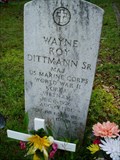 view gallery view galleryE5.3 km |  Maj. Wayne Roy Dittman, Sr., USMC, Hartwood, VA Maj. Wayne Roy Dittman, Sr., USMC, Hartwood, VA
in Grave of a Famous Person Major Dittman, USMC, is famous in my book for serving this counrty in three wars. posted by: garmin_geek location: Virginia date approved: 05/15/2009 last visited: 05/20/2010 |
 view gallery view galleryS5.3 km |  "The Confluence" Rapidan & Rappahannock Rivers, VA "The Confluence" Rapidan & Rappahannock Rivers, VA
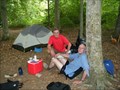
in Free Campsites This is just one of at least 10 free campsites in the area of the confluence of the Rapidan and Rappahannock Rivers. Access is only via canoe or kayak on the rivers. posted by: garmin_geek location: Virginia date approved: 06/07/2011 last visited: never |
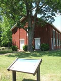
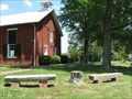 view gallery view galleryE5.3 km |  Hartwood Presbyterian Church Meditation Benches - Stafford VA Hartwood Presbyterian Church Meditation Benches - Stafford VA
in Eagle Scout Project Sites Edward Scott Hughes spruced up the landscape of the cemetery at a church in Hartwood, VA and built two meditation benches to obtain his Eagle Scout rank. posted by: La de Boheme location: Virginia date approved: 05/21/2010 last visited: never |
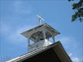 view gallery view galleryE5.3 km |  Hartwood Church Belfry - Hartwood VA Hartwood Church Belfry - Hartwood VA
in Bell Towers A Presbyterian church rings in the congregation with a bell from an Episcopalian church. posted by: La de Boheme location: Virginia date approved: 05/21/2010 last visited: never |
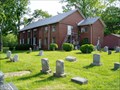
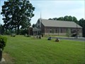
 view gallery view galleryE5.3 km |  Hartwood Presbyterian Church - Stafford County VA Hartwood Presbyterian Church - Stafford County VA
in U.S. National Register of Historic Places Sevices are still held at historic Hartwood Presbyterian Church which is over 150 years old. posted by: La de Boheme location: Virginia date approved: 05/21/2010 last visited: never |
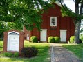 view gallery view galleryE5.3 km |  1825 ~ Hartwood Presbyterian Church, Hartwood, VA 1825 ~ Hartwood Presbyterian Church, Hartwood, VA
in This Old Church Organized in June 1825 by the Winchester Presbytery as Yellow Chapel Church, the brick church was constructed between 1857 and 1859. It became Hartwood Presbyterian Church in 1868. posted by: garmin_geek location: Virginia date approved: 05/15/2009 last visited: 05/20/2010 |
 view gallery view galleryE5.3 km |  Hartwood Presbyterian Church, Hartwood, VA Hartwood Presbyterian Church, Hartwood, VA
in Churchyard Cemeteries Hartwood Presbyterian Church, Hartwood, VA posted by: garmin_geek location: Virginia date approved: 05/16/2009 last visited: 05/20/2010 |
 view gallery view galleryE5.3 km |  Hartwood Church Hartwood Church
in Civil War Discovery Trail Sites During the Civil War, Federal troops occupied and desecrated this church, but were subsequently captured by a Confederate squadron who surprised them while they slept. posted by: La de Boheme location: Virginia date approved: 05/23/2010 last visited: never |
 view gallery view gallery SW8 km SW8 km
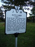
| Ely's Ford in Virginia Historical Markers Virginia Historical Highway Marker, J-38. Ely's Ford. posted by: garmin_geek location: Virginia date approved: 10/21/2011 last visited: never |
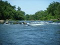 view gallery view gallerySW8 km |  Ely's Ford - Mott's Run, Rapidan & Rappahannock Rivers, VA Ely's Ford - Mott's Run, Rapidan & Rappahannock Rivers, VA
in Canoe/Kayak Trips This is about a 14.5 mile one-way river paddle on the Rapidan and Rappahannock. It is a 2 day fishing trip with camping at the confluence or a 1 day paddle only trip. posted by: garmin_geek location: Virginia date approved: 06/09/2011 last visited: never |
 view gallery view galleryE9 km | Antioch United Methodist Church, Fredericksburg, VA in Churchyard Cemeteries A small church and fence enclosed cemetery located at 138 Kellogg Mill Road, Fredericksburg, VA 22406-4300 (Stafford County) posted by: garmin_geek location: Virginia date approved: 06/24/2011 last visited: never |
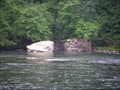 view gallery view galleryS9 km |  Remains ~ Scott's Dam and Guard Lock Remains ~ Scott's Dam and Guard Lock
in Waterway Locks, Planes and Lifts Remains of a 19th century guard lock, part of the Rappahannock River Canal above Fredericksburg, VA posted by: garmin_geek location: Virginia date approved: 06/19/2011 last visited: never |
 view gallery view galleryE9.7 km | Mt. Olive Baptist Church, Stafford, VA in Churchyard Cemeteries This cemetery is located across the road from the old and new buildings. Located at 395 Mount Olive Rd., Stafford, VA 22555. posted by: garmin_geek location: Virginia date approved: 06/24/2011 last visited: never |
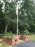 view gallery view galleryNW9.8 km | Veteran's Memorial, Summerduck Baptist Church Cemetery in Eagle Scout Project Sites A beautiful brick Veteran's Memorial by C. Curtis Yancey 12/2007. posted by: garmin_geek location: Virginia date approved: 09/12/2011 last visited: never |
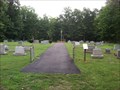 view gallery view galleryNW9.8 km |  Sumerduck Baptist Church Cemetery, Sumerduck, VA Sumerduck Baptist Church Cemetery, Sumerduck, VA
in Worldwide Cemeteries Also known as the Embry Cemetery off the Google maps. posted by: garmin_geek location: Virginia date approved: 09/14/2011 last visited: never |
 view gallery view gallery SE9.8 km SE9.8 km
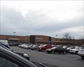
|  Walmart - Village Pkwy - Fredericksburg, VA Walmart - Village Pkwy - Fredericksburg, VA
in WAL*MART Stores This is one of the four Walmart locations in Fredericksburg, VA. posted by: retail96 location: Virginia date approved: 10/08/2018 last visited: 10/07/2018 |
 view gallery view galleryS10.9 km | Hooker's Final Bastion The Battle of Chancellorsville - Chancellorsville VA in U.S. Civil War Sites After suffering defeat in the massive fighting on May 3, Hooker's army started digging. The result: a powerful, U-shaped line six miles long supported by 100 cannons. posted by: Don.Morfe location: Virginia date approved: 09/12/2020 last visited: 08/18/2014 |
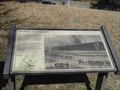 view gallery view galleryS10.9 km |  Hooker's Final Bastion-The Battle of Chancellorsville - Chancellorsville VA Hooker's Final Bastion-The Battle of Chancellorsville - Chancellorsville VA
in Battlefields After suffering defeat in the massive fighting on May 3, Hooker's army started digging. The result: a powerful, U-shaped line six miles long supported by 100 cannons. posted by: Don.Morfe location: Virginia date approved: 08/21/2023 last visited: 08/18/2014 |
 view gallery view galleryS10.9 km |  Hooker's Final Bastion-The Battle of Chancellorsville - Chancellorsville VA Hooker's Final Bastion-The Battle of Chancellorsville - Chancellorsville VA
in Signs of History After suffering defeat in the massive fighting on May 3, Hooker's army started digging. The result: a powerful, U-shaped line six miles long supported by 100 cannons. posted by: Don.Morfe location: Virginia date approved: 08/21/2023 last visited: 08/18/2014 |
|