 view gallery view gallery NE4.5 km NE4.5 km
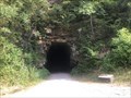
|   Sharps Tunnel - Marlington, West Virginia Sharps Tunnel - Marlington, West Virginia
in Abandoned Train Tunnels Located along the Greenbrier Trail between Marlington and Clover Lick. posted by:  flyingmoose flyingmoose location: West Virginia date approved: 08/10/2021 last visited: never |
 view gallery view gallery NW5.1 km NW5.1 km
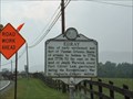
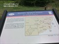
|  Edray Edray
in West Virginia Historical Markers Site of early settlement and fort of Thomas Drinnon posted by:  two-bit Joe two-bit Joe location: West Virginia date approved: 03/26/2011 last visited: 05/04/2013 |
 view gallery view gallery SW5.3 km SW5.3 km
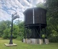
|  Greenbrier Rail Line Water Tower, Marlington, West Virginia Greenbrier Rail Line Water Tower, Marlington, West Virginia
in Water Towers Located on the Greenbrier River Trail on the north end of Marlington. posted by: flyingmoose location: West Virginia date approved: 08/12/2021 last visited: never |
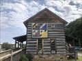 view gallery view gallerySW5.8 km |  Log Cabin - Marlington, West Virginia Log Cabin - Marlington, West Virginia
in Painted Barn Quilts Large barn quilt on the side of the Greenbrier River Trail. posted by: flyingmoose location: West Virginia date approved: 08/10/2021 last visited: never |
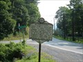
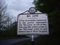 view gallery view galleryNW5.8 km | Big Lime in West Virginia Historical Markers Oli and natural gas of the Greenbrier Limestone. posted by: Paintedwarrior location: West Virginia date approved: 05/16/2013 last visited: 04/08/2016 |
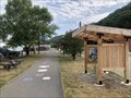 view gallery view gallerySW6 km |  Greenbrier River Trail - Marlington, West Virginia Greenbrier River Trail - Marlington, West Virginia
in Rails to Trails Located at the intersection of 8th Street and the Greenbriar Trail posted by: flyingmoose location: West Virginia date approved: 08/10/2021 last visited: never |
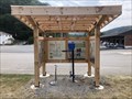 view gallery view gallerySW6 km |  Greenbrier River Trail - Marlington, West Virginia Greenbrier River Trail - Marlington, West Virginia
in Bicycle Repair Stations Located at the trailhead of the Greenbrier River Trail near 8th Street. posted by: flyingmoose location: West Virginia date approved: 08/10/2021 last visited: never |
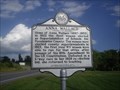
 view gallery view gallerySW6.4 km | Marlinton in West Virginia Historical Markers Dual marker near Marlinton posted by: two-bit Joe location: West Virginia date approved: 03/26/2011 last visited: 05/05/2012 |
 view gallery view gallery S7.2 km S7.2 km
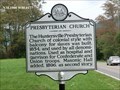
| Presbyterian Church in West Virginia Historical Markers The Huntersville Presbyterian Church of the colonial style with balcony for slaves was built, 1854, and used by all denominations. posted by: Don.Morfe location: West Virginia date approved: 03/09/2020 last visited: 10/24/2021 |
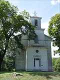 view gallery view galleryS7.2 km |  Huntersville Presbyterian Church - Huntersville, WV Huntersville Presbyterian Church - Huntersville, WV
in U.S. National Register of Historic Places The Huntersville Presbyterian Church is one of the oldest building in the Community of Huntersville. posted by: Sneakin Deacon location: West Virginia date approved: 11/02/2009 last visited: never |
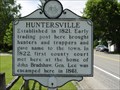 view gallery view galleryS7.4 km | Huntersville in West Virginia Historical Markers This historic marker is located small community of Huntersville, West Virginia. posted by: Sneakin Deacon location: West Virginia date approved: 09/02/2009 last visited: 05/05/2012 |
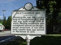 view gallery view galleryS7.4 km | Huntersville Jail in West Virginia Historical Markers This historic marker is located in the community of Hunterville, West Virginia. posted by: Sneakin Deacon location: West Virginia date approved: 09/02/2009 last visited: 05/05/2012 |
 view gallery view galleryS8.4 km | Tuscarora (Clinton) Sand in West Virginia Historical Markers This marker stands on Route 39 at Knapps Creek in Pocahontas County, West Virginia. posted by: Sneakin Deacon location: West Virginia date approved: 01/05/2010 last visited: 05/05/2012 |
 view gallery view galleryNE10.5 km |  Clover Lick Station, Clover Lick, West Virginia Clover Lick Station, Clover Lick, West Virginia
in Train Stations/Depots Located at the intersection of Edray Road and Back Mountain Road in Clover Lick posted by: flyingmoose location: West Virginia date approved: 08/12/2021 last visited: never |
 view gallery view galleryNE10.5 km | Greenbrier River Trail - Clover Lick, West Virginia in Rails to Trails Located at the intersection of Edray Road and Back Mountain Road in Clover Lick posted by: flyingmoose location: West Virginia date approved: 08/10/2021 last visited: never |
 view gallery view gallerySW10.8 km | Greenbrier River Trail - Buckeye, West Virginia in Rails to Trails Located at the intersection of Buckeye Station Road and the Greenbriar Trail east of Buckeye. posted by: flyingmoose location: West Virginia date approved: 08/10/2021 last visited: never |
 view gallery view gallery SE10.8 km SE10.8 km
|  Camp Northwest-Jackson’s Huntersville Line - Minnehaha Springs WV Camp Northwest-Jackson’s Huntersville Line - Minnehaha Springs WV
in Civil War Discovery Trail Sites Huntersville (three miles northwest of here) in January 1862. Camp Northwest became Confederate Col. William L. Jackson’s headquarters and a supply depot for the outposts under Jackson’s command. posted by: Don.Morfe location: West Virginia date approved: 08/25/2020 last visited: 10/04/2021 |
 view gallery view gallerySW15.4 km | William L. "Mudwall" Jackson 19th & 20th Virginia Cavalry C.S.A. - Hillsboro WV in Civil War Discovery Trail Sites William L. "Mudwall" Jackson and the main body of the 19th Virginia Cavalry were in camp near Mill Point on November 3, 1863, when they received a message from Lt. George W. Siple, posted by: Don.Morfe location: West Virginia date approved: 08/25/2020 last visited: 10/04/2021 |
 view gallery view gallerySW15.4 km | William L. "Mudwall" Jackson-19th & 20th Virginia Cavalry C.S.A. - Hillsboro WV in U.S. Civil War Sites Marker is in Hillsboro, West Virginia, in Pocahontas County. Marker is at the intersection of U.S. 219 and Steven Hole Run Road (County Route 219/8), Hillsboro WV 24946 posted by: Don.Morfe location: West Virginia date approved: 07/09/2023 last visited: 07/09/2023 |
 view gallery view gallerySW16.4 km | Anna Wallace in West Virginia Historical Markers A sign telling us about Anna Wallace being elected Superintendent of Schools for Pocahontas County. posted by: Paintedwarrior location: West Virginia date approved: 07/27/2015 last visited: 07/28/2015 |
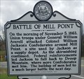 view gallery view gallerySW16.4 km | Battle of Mill Point in West Virginia Historical Markers Describes a small skirmish prior to the Droop Mountain battle. posted by: dukemartin location: West Virginia date approved: 04/02/2024 last visited: never |
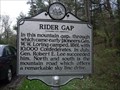 view gallery view gallerySE16.6 km | Rider Gap in West Virginia Historical Markers 10,000 Confederates camped here in 1861. posted by: Paintedwarrior location: West Virginia date approved: 05/16/2013 last visited: 05/18/2013 |
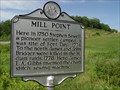 view gallery view gallerySW16.6 km | Mill Point in West Virginia Historical Markers This historic marker stands on Route 219 in Pocohontas County. posted by: Sneakin Deacon location: West Virginia date approved: 11/08/2009 last visited: 05/11/2013 |
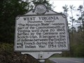 view gallery view gallerySE16.6 km | West Virginia (Pocahontas County) / Virginia in West Virginia Historical Markers West Virginia settled by Germans and Scotch~Irish. Virginia one of the 13 original colonies. posted by: Paintedwarrior location: West Virginia date approved: 05/16/2013 last visited: 05/18/2013 |
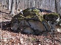 view gallery view galleryNW16.7 km |  Honeycomb Rocks and Trail Honeycomb Rocks and Trail
in Places of Geologic Significance A group of interesting geologic formations located on a short, self guided trail. Handicapped accessible. posted by: woodhick803 location: West Virginia date approved: 11/15/2010 last visited: 06/24/2019 |
|