  S4.2 km S4.2 km
|   Horton Cellers Horton Cellers
in Wineries An award winning winery in the Montecello Vinicultural region of the piedmont of Virginia. posted by:  ganurse6 ganurse6 location: Virginia date approved: 07/02/2006 last visited: 10/06/2011 |
S5.1 km | Burnley Vinyards in Wineries A family run Vinyard and winery in the Montecello vinicultural region of the Virginia Piedmont. posted by: ganurse6 location: Virginia date approved: 07/02/2006 last visited: never |
 view gallery view gallery NW5.1 km NW5.1 km
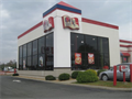
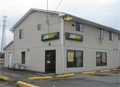
|  KFC - US Route 29 - Ruckersville, Virginia KFC - US Route 29 - Ruckersville, Virginia
in Kentucky Fried Chicken/KFC Restaurants A KFC paired with a Taco Bell near the junction of US Routes 29 and 33 in the unincorporated community of Ruckersville in Greene County, Virginia posted by: outdoorboy34 location: Virginia date approved: 02/21/2014 last visited: never |
 view gallery view galleryNW5.1 km |  Taco Bell - US Route 29 - Ruckersville, Virginia Taco Bell - US Route 29 - Ruckersville, Virginia
in Taco Bell Restaurants A Taco Bell paired with a KFC, located near the junction of US Routes 29 and 33 in the hamlet of Ruckersville, Greene County, VA posted by: outdoorboy34 location: Virginia date approved: 02/19/2014 last visited: never |
 view gallery view galleryNW5.1 km |  Wendy's - US Route 29 - Ruckersville, Virginia Wendy's - US Route 29 - Ruckersville, Virginia
in Wendy's Restaurants A Wendy's near the juncture of US Routes 29 and 33 in the hamlet of Ruckersville, Greene County, Virginia posted by: outdoorboy34 location: Virginia date approved: 02/21/2014 last visited: never |
 view gallery view gallery SE5.1 km SE5.1 km
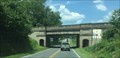
|  Barboursville Railbridge - Barboursville, VA Barboursville Railbridge - Barboursville, VA
in Railroad Bridges Railroad bridge along US 33 posted by:  stinger503 stinger503 location: Virginia date approved: 07/19/2017 last visited: never |
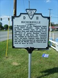 view gallery view galleryNW5.1 km |  Ruckersville Ruckersville
in Virginia Historical Markers Virginia Historical Highway Marker D-11 posted by: garmin_geek location: Virginia date approved: 06/22/2010 last visited: 06/01/2001 |
 view gallery view galleryNW5.1 km |  Subway #10392 - US Route 29 - Ruckersville, VA Subway #10392 - US Route 29 - Ruckersville, VA
in Subway Restaurants A Subway location near the juncture of US Routes 29 and 33 in the small hamlet of Ruckersville, Greene County, Virginia posted by: outdoorboy34 location: Virginia date approved: 02/19/2014 last visited: never |
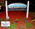 view gallery view galleryNW5.1 km |  "Welcome to Ruckersville" "Welcome to Ruckersville"
in Eagle Scout Project Sites Phillip Strauss Eagle Scout service project. posted by: tiki-4 location: Virginia date approved: 02/08/2009 last visited: 09/17/2009 |
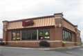
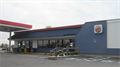 view gallery view galleryNW5.3 km |  Burger King #7205 - US Routes 33 and 29 - Ruckersville, VA Burger King #7205 - US Routes 33 and 29 - Ruckersville, VA
in Burger King Restaurants A BK Hybrid located at the junction of US Routes 29 and 33 in the community of Ruckersville, Greene County, Virginia posted by: outdoorboy34 location: Virginia date approved: 02/19/2014 last visited: never |
 view gallery view galleryNW5.5 km |  McDonald's - Ruckersville, VA McDonald's - Ruckersville, VA
in McDonald's Restaurants Brand-new McDs along Highway 33, just off Highway 29 posted by: vhasler location: Virginia date approved: 04/08/2012 last visited: 07/15/2017 |
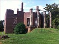 view gallery view gallerySE6 km |  Barboursville - Barboursville, VA Barboursville - Barboursville, VA
in U.S. National Register of Historic Places Designed by Thomas Jefferson for Governor James Barbour. Built 1814, Destroyed by Fire Christmas Day, 1884. posted by: heringermr location: Virginia date approved: 07/12/2011 last visited: 06/18/2013 |
 view gallery view gallery W6.6 km W6.6 km
| Greene & Albemarle Counties in Virginia Historical Markers Double sided counties sign. Each side corresponds to county it faces. posted by: johnjm99 location: Virginia date approved: 02/25/2006 last visited: never |
 view gallery view gallerySE8.5 km |  Zachary Taylor Zachary Taylor
in Presidential Birthplaces He was the second president to die--from illness-- in office and the second president to die in the White House.
posted by: tiki-4 location: Virginia date approved: 11/13/2005 last visited: 04/02/2012 |
 view gallery view gallery E9.2 km E9.2 km
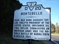
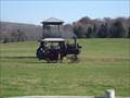
|  Somerset Somerset
in Old Tractors East side of VA 231 posted by: tiki-4 location: Virginia date approved: 11/19/2005 last visited: never |
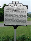 view gallery view galleryS10 km | Southwest Mountains Rural Historic District in Virginia Historical Markers Located along the westbound side of Route 20. There is ample parking due to the fact it is in front of a grocery store. posted by: flyingmoose location: Virginia date approved: 07/13/2006 last visited: never |
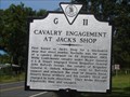 view gallery view gallery NE10.6 km NE10.6 km
| Cavalry Engagement at Jack's Shop in Virginia Historical Markers J.E.B. Stuart escapes the vise of Union troops. posted by: VirginiaSeeker location: Virginia date approved: 09/14/2008 last visited: 10/26/2011 |
 view gallery view galleryE11.9 km |  Jacksontown Road Bridge Jacksontown Road Bridge
in Plank Roads Plank bridge posted by: tiki-4 location: Virginia date approved: 11/19/2005 last visited: 10/18/2009 |
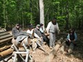 view gallery view galleryE12.6 km |  Camp McGowan Winter Hut Encampment - Orange County VA USA Camp McGowan Winter Hut Encampment - Orange County VA USA
in Historic Reenactments In the early months of 1864, Confederate General McGowan's South Carolina Brigade set up winter encampment in the area surrounding Montpelier. posted by: La de Boheme location: Virginia date approved: 05/10/2010 last visited: 08/13/2011 |
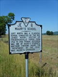 view gallery view gallerySE12.6 km | Maury's School in Virginia Historical Markers Virginia Historical Highway Marker JE-6 posted by: garmin_geek location: Virginia date approved: 06/19/2010 last visited: 10/12/2014 |
 view gallery view galleryE12.7 km |  Gilmore Farm - Montpelier Station VA Gilmore Farm - Montpelier Station VA
in Homesteads George Gilmore, born a slave on James Madison's Montpelier estate, was emancipated after the Civil War. He built this cabin for his wife Polly and their five children. In 1901, at age 91, he purchased the 16.1 acres that he farmed. posted by: HaricotVert_52 location: Virginia date approved: 10/19/2009 last visited: 04/18/2010 |
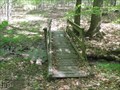 view gallery view galleryE12.7 km |  Confederate Camp and Freedman's Farm Trail - Montpelier Station VA Confederate Camp and Freedman's Farm Trail - Montpelier Station VA
in Hiking Path Footbridges Cross a wooden bridge while hiking through an old Confederate winter encampment. posted by: La de Boheme location: Virginia date approved: 04/25/2010 last visited: never |
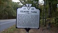 view gallery view galleryE12.7 km | Gilmore Farm in Virginia Historical Markers The Gilmore Farm marker identifies the location of a restored freedman's farm, that of George Gilmore, born a slave at James Madison's Montpelier estate. posted by: HaricotVert_52 location: Virginia date approved: 11/08/2009 last visited: 03/12/2015 |
 view gallery view galleryE12.9 km |  Montpelier 'Riveted Tank' Montpelier 'Riveted Tank'
in Water Towers In the world of water storage, the icon is the riveted tank. Once the pride of the community, these towers were proof that towns had outgrown their village or hamlet status. Whenever the subject of water towers comes up, it's the riveted tank that appears in the mind's eye. References to the tin woodsman in the Wizard of Oz are frequent. State-of-the-art when installed, these towers were built better than they had to be and are still holding their water in tens of thousands of towns. Ironically, posted by: tiki-4 location: Virginia date approved: 11/20/2005 last visited: 04/18/2010 |
 view gallery view gallery SW12.9 km SW12.9 km
|  Arby's #7049 - Timberwood Blvd. - Charlottesville - Virginia Arby's #7049 - Timberwood Blvd. - Charlottesville - Virginia
in Arby's Restaurants An Arby's located off of Seminole Trail (US Route 29) in suburban Albemarle County, Virginia posted by: outdoorboy34 location: Virginia date approved: 03/10/2014 last visited: never |
|