 view gallery view gallery W1.3 km W1.3 km
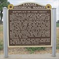
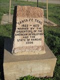
|   Birthplace of Farm Credit - Larned, KS Birthplace of Farm Credit - Larned, KS
in Kansas Historical Markers Located in front of a farm a few miles southwest of Larned on US-56. posted by:  linkys linkys location: Kansas date approved: 07/01/2012 last visited: never |
 view gallery view gallery NW4.3 km NW4.3 km
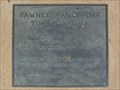
|  Pawnee Panorama Time Capsule - Larned, KS Pawnee Panorama Time Capsule - Larned, KS
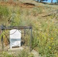
in Time Capsules Time capsule in the courtyard of the Santa Fe Trail Center in Larned, Kansas posted by: linkys location: Kansas date approved: 06/10/2012 last visited: 03/03/2020 |
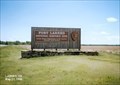
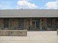 view gallery view galleryNW4.3 km |  Santa Fe Trail Center - Larned, KS Santa Fe Trail Center - Larned, KS
in History Museums The Santa Fe Trail Center concentrates on the civilian history of the Santa Fe Trail posted by: linkys location: Kansas date approved: 06/09/2012 last visited: never |
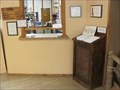 view gallery view galleryNW4.3 km |  Santa Fe Trail Center - Larned, KS Santa Fe Trail Center - Larned, KS
in Guest Books Guest book in the Santa Fe Trail Center west of Larned, Kansas. posted by: linkys location: Kansas date approved: 06/12/2012 last visited: never |
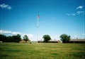
 view gallery view galleryW10.3 km |  Fort Larned National Historic Site - Larned KS Fort Larned National Historic Site - Larned KS
in National Parks of the World Fort Larned National Historic Site preserves Fort Larned which operated from 1859 to 1878. It is approximately 5.5 miles (8.9 km) west of Larned, Kansas, United States. posted by: Don.Morfe location: Kansas date approved: 05/13/2022 last visited: 05/07/2022 |
 view gallery view galleryW10.3 km |  Fort Larned National Historic Site - Larned KS Fort Larned National Historic Site - Larned KS
in Official Local Tourism Attractions Fort Larned National Historic Site preserves Fort Larned which operated from 1859 to 1878. It is approximately 5.5 miles (8.9 km) west of Larned, Kansas, United States. posted by: Don.Morfe location: Kansas date approved: 05/07/2022 last visited: 05/07/2022 |
 view gallery view galleryW10.3 km |  Fort Larned National Historic Site - Larned KS Fort Larned National Historic Site - Larned KS
in Wikipedia Entries Fort Larned National Historic Site preserves Fort Larned which operated from 1859 to 1878. It is approximately 5.5 miles (8.9 km) west of Larned, Kansas, United States. posted by: Don.Morfe location: Kansas date approved: 05/07/2022 last visited: 05/07/2022 |
 view gallery view galleryW10.3 km |  Fort Larned National Historic Site - Larned KS Fort Larned National Historic Site - Larned KS
in Satellite Imagery Oddities Fort Larned National Historic Site preserves Fort Larned which operated from 1859 to 1878. It is approximately 5.5 miles (8.9 km) west of Larned, Kansas, United States. posted by: Don.Morfe location: Kansas date approved: 05/07/2022 last visited: 05/07/2022 |
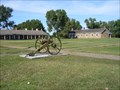 view gallery view galleryW10.5 km | ") Fort Larned National Historic Site Fort Larned National Historic Site
in National Parks (U.S.) Fort Larned National Historic Site, located just west of Larned, Kansas, preserves Fort Larned, which was established in 1859 as a base of military operations against hostile Indians of the Central Plains, to protect traffic along the Santa Fe Trail posted by: leadhiker location: Kansas date approved: 01/25/2010 last visited: 05/07/2022 |
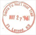
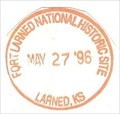 view gallery view galleryW10.5 km |  Fort Larned National Historic Site - Larned, KS Fort Larned National Historic Site - Larned, KS
in NPS Passport Cancellation Stations Fort Larned is a well-preserved fort on the Santa Fe Trail shares a tumultuous history of the Indian Wars era. posted by: Don.Morfe location: Kansas date approved: 02/14/2020 last visited: 10/10/2021 |
 view gallery view galleryW10.5 km | Santa Fe National Historic Trail-Fort Larned KS - Larned, KS in NPS Passport Cancellation Stations The Great Prairie Highway
You can almost hear the whoops and cries of "All's set!" as trail hands hitched their oxen to freight wagons carrying cargo between western Missouri and Santa Fe, New Mexico. posted by: Don.Morfe location: Kansas date approved: 02/25/2020 last visited: 10/10/2021 |
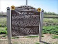 view gallery view gallery NE14.6 km NE14.6 km
| Pawnee Rock in Kansas Historical Markers Marker with information about historic landmark along the Santa Fe Trail located just west of the town of Pawnee Rock. posted by:  BruceS BruceS location: Kansas date approved: 06/18/2012 last visited: 04/22/2017 |
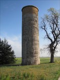 view gallery view gallery SW15.3 km SW15.3 km
|  Downey Memorial Park Silo - Garfield, Kansas Downey Memorial Park Silo - Garfield, Kansas
in Solitary Silos Silo on east side of Garfield, Kansas. posted by: BruceS location: Kansas date approved: 06/07/2012 last visited: 04/06/2017 |
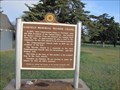 view gallery view gallerySW15.4 km | Garfield Memorial Wayside Chapel - Garfield, Kansas in Kansas Historical Markers Marker for wayside chapel in small park on east side of Garfield, Kansas. posted by: BruceS location: Kansas date approved: 06/18/2012 last visited: 04/06/2017 |
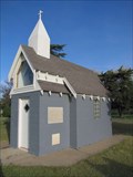 view gallery view gallerySW15.4 km |  Garfield Memorial Wayside Chapel - Garfield, Kansas Garfield Memorial Wayside Chapel - Garfield, Kansas
in Waychapels Wayside chapel in a small park on the east side of Garfield, Kansas. posted by: BruceS location: Kansas date approved: 06/08/2012 last visited: 04/06/2017 |
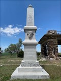 view gallery view galleryNE15.8 km |  DAR Pawnee Rock monument - Pawnee Rock, KS, USA DAR Pawnee Rock monument - Pawnee Rock, KS, USA
in Daughters of the American Revolution Located in Pawnee Rock State Park. The granite obelisk was placed by the Woman's Kansas Day Club, a consortium of women's clubs, which included the Kansas DAR at the time. posted by:  *AcademicGamer *AcademicGamer location: Kansas date approved: 08/21/2023 last visited: never |
 view gallery view galleryNE15.8 km |  Santa Fe Trail - Pawnee Rock, KS Santa Fe Trail - Pawnee Rock, KS
in Wagon Roads and Trails Granite Santa Fe Trail marker posted by: linkys location: Kansas date approved: 06/09/2012 last visited: 07/07/2018 |
 view gallery view galleryNE15.9 km |  Nehemiah Carson - Pawnee Rock State Park - Pawnee Rock, Kansas Nehemiah Carson - Pawnee Rock State Park - Pawnee Rock, Kansas
in Out of Place Graves Nehemiah Carson was a member of the 1st Missouri Mounted Infantry as part of Alexander Doniphan's expedition to Santa Fe as part of the Mexican American War. posted by: iconions location: Kansas date approved: 04/12/2018 last visited: never |
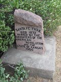
 view gallery view gallerySW15.9 km | Santa Fe Trail - Garfield, Kansas in Wagon Roads and Trails Stone trail monument in Garfield, Kansas. posted by: BruceS location: Kansas date approved: 06/07/2012 last visited: 04/06/2017 |
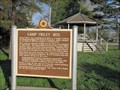 view gallery view gallerySW15.9 km | Camp Criley 1872 - Garfield, Kansas in Kansas Historical Markers Marker giving history of town of Garfield which was originally known as Camp Criley. posted by: BruceS location: Kansas date approved: 06/18/2012 last visited: 04/06/2017 |
 view gallery view gallery S23.8 km S23.8 km
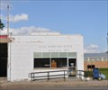
|  Belpre, Kansas 67519 Belpre, Kansas 67519
in U.S. Post Offices This Post Office is located at 506 Dudley Street in Belpre, Kansas. posted by: brwhiz location: Kansas date approved: 09/02/2012 last visited: 08/15/2021 |
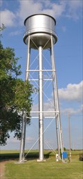
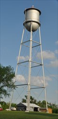 view gallery view galleryS24 km |  Belpre Water Tower Belpre Water Tower
in Water Towers This water tower is located in the center of the block bordered by Laird Street, Hudson Avenue, Dudley Street, and Wheeler Avenue in Belpre, Kansas. posted by: brwhiz location: Kansas date approved: 02/05/2013 last visited: 05/29/2017 |
 view gallery view galleryS24 km |  HG0885 ~ BELPRE MUNICIPAL TANK HG0885 ~ BELPRE MUNICIPAL TANK
in U.S. Benchmarks This survey mark is the top center of the water tower located in the center of the block bordered by Laird Street, Hudson Avenue, Dudley Street, and Wheeler Avenue in Belpre, Kansas. posted by: brwhiz location: Kansas date approved: 02/04/2013 last visited: never |
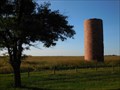 view gallery view galleryS25.3 km | Solitary Silo - Belpre, KS in Solitary Silos A solitary silo along Highway 50 in Belpre, KS posted by: Telomere location: Kansas date approved: 09/11/2016 last visited: never |
 view gallery view gallery SE25.3 km SE25.3 km
| Macksville, Kansas Water Tower in Water Towers This water tower is located just northeast of the intersection of Hancock and Main Streets, just north of the railroad tracks on the north edge of Macksville, Kansas. posted by: brwhiz location: Kansas date approved: 02/05/2013 last visited: never |
|