 view gallery view gallery W1.1 km W1.1 km
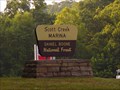
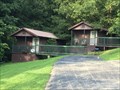
|   Scott Creek Marina - Cave Run Lake - Kentucky, USA Scott Creek Marina - Cave Run Lake - Kentucky, USA
in Marinas From I64 Take exit 133. Turn right onto HWY801 North. Drive approximately 3 miles to US60 Junction. Cross US60 onto HWY801 South. Drive approximately 4.5 miles South to Scott Creek Marina Road on the right. Sign at roadway. posted by:  Simplenfun Simplenfun location: Kentucky date approved: 10/12/2016 last visited: 10/13/2016 |
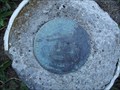
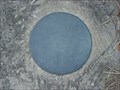 view gallery view galleryW1.1 km |  Cave Run Lake - Scott Creek Marina - Elevation Marker Cave Run Lake - Scott Creek Marina - Elevation Marker
in U.S. Benchmarks This elevation marker is located on the steps in a parking lot for the Scott Creek Marina at Cave Run Lake. posted by: Simplenfun location: Kentucky date approved: 09/03/2011 last visited: 10/11/2016 |
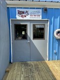 view gallery view galleryW1.1 km |  Reno's on the Run - Cave Run Lake, Morehead, Kentucky USA Reno's on the Run - Cave Run Lake, Morehead, Kentucky USA
in Dockside Restaurants Renos on the Run is offers Breakfast, Lunch and Dinner. And we will be serving the best pizza around! at Scott Creek Marina posted by: Crazy4horses location: Kentucky date approved: 09/02/2021 last visited: 09/06/2021 |
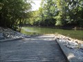
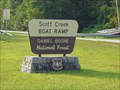 view gallery view galleryW1.3 km |  Scott Creek Ramp - Cave Run Lake - Kentucky, USA Scott Creek Ramp - Cave Run Lake - Kentucky, USA
in Boat Ramps This boat ramp is the closest to the Cave Run Lake dam. posted by: Simplenfun location: Kentucky date approved: 09/05/2011 last visited: 10/11/2016 |
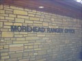
 view gallery view gallery NW2.6 km NW2.6 km
|  Morehead Ranger District - Safe Place Morehead Ranger District - Safe Place
in Safe Place Havens This Cumberland District Ranger Station of the Daniel Boone National Forest is also a Safe Haven! posted by: Simplenfun location: Kentucky date approved: 08/29/2011 last visited: 10/11/2016 |
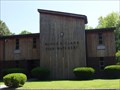
 view gallery view galleryNW3.2 km |  Cumberland Ranger District - Cave Run Lake, KY, US Cumberland Ranger District - Cave Run Lake, KY, US
in Ranger Stations Cumberland Ranger District
2375 KY 801 South
Morehead, KY 40351
606-784-6428 posted by: Crazy4horses location: Kentucky date approved: 08/09/2016 last visited: 10/10/2016 |
 view gallery view galleryNW3.4 km |  Cumberland District Ranger Station Overlook - DBNF - KY, USA Cumberland District Ranger Station Overlook - DBNF - KY, USA
in Scenic Overlooks One of the best things about this ranger station is the nice view from the walkout overlook at the rear of the building! posted by: Simplenfun location: Kentucky date approved: 08/29/2011 last visited: 10/11/2016 |
 view gallery view galleryNW3.4 km | Cumberland Ranger District - Daniel Boone National Forest - KY, USA in Ranger Stations The Daniel Boone National Forest is divided into four ranger districts. posted by: Simplenfun location: Kentucky date approved: 08/28/2011 last visited: 10/11/2016 |
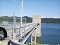 view gallery view galleryNW3.5 km |  Cave Run Lake Dam - Farmers, Kentucky Cave Run Lake Dam - Farmers, Kentucky
in Water Dams Cave Run Lake was created by the construction of an earth and rock-fill dam across the Licking River. posted by: Simplenfun location: Kentucky date approved: 08/29/2011 last visited: 10/11/2016 |
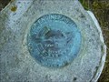
 view gallery view galleryNW3.7 km | Cave Run Lake Reset in U.S. Benchmarks Reset disk located on North Rowan County end of Cave Run Lake dam. posted by: Simplenfun location: Kentucky date approved: 08/28/2011 last visited: 10/11/2016 |
 view gallery view galleryNW3.7 km | Cave Run Lake Scenic Overlook Survey Mark in U.S. Benchmarks Disk located near scenic viewing area of Cave Run Lake. posted by: Simplenfun location: Kentucky date approved: 08/28/2011 last visited: 10/11/2016 |
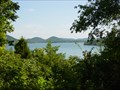 view gallery view galleryNW3.7 km | Cave Run Lake Scenic Overlook in Scenic Overlooks One of the beautiful views of Cave Run Lake! posted by: Simplenfun location: Kentucky date approved: 08/29/2011 last visited: 10/11/2016 |
 view gallery view galleryNW3.9 km | Cave Run Lake Tailwater Boat Ramp in Boat Ramps This boat ramp in the tailwater area of Cave Run Lake provides easy access to the Licking River below the dam. posted by: Simplenfun location: Kentucky date approved: 09/05/2011 last visited: 10/11/2016 |
 view gallery view galleryNW4 km |  Minor E. Clark Fish Hatchery - Morehead, KY, USA Minor E. Clark Fish Hatchery - Morehead, KY, USA
in Fish Hatcheries Below Cave Run Lake dam is the Minor E. Clark Fish Hatchery, operated by the Kentucky Department of Fish and Wildlife Resources. posted by: Simplenfun location: Kentucky date approved: 08/28/2011 last visited: 10/11/2016 |
 view gallery view galleryW4.2 km |  Licking River Gage at Cave Run Lake Tailwater Licking River Gage at Cave Run Lake Tailwater
in River Gauges This gauge on the Licking River is located just below the tailwater area of Cave Run Lake. posted by: Simplenfun location: Kentucky date approved: 09/11/2011 last visited: 10/11/2016 |
 view gallery view gallery NE4.3 km NE4.3 km
|  Rowan County High Point - KY, USA Rowan County High Point - KY, USA
in Geographic High Points The highest elevation in the county is Limestone Knob (1435 ft), situated approximately 3 miles southwest of Morehead posted by: Crazy4horses location: Kentucky date approved: 01/04/2017 last visited: 01/04/2017 |
 view gallery view galleryNW4.5 km |  Cave Run Cabins - Farmers, KY, US Cave Run Cabins - Farmers, KY, US
in Chalet, Cottage, and Cabin Style Lodging Located just a half mile from the Daniel Boone National Forest and Cave Run Lake, off KY-801 south off of US 60. posted by: Crazy4horses location: Kentucky date approved: 08/08/2016 last visited: 10/10/2016 |
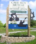 view gallery view galleryNW5 km |  Cave Run Bicycle and Outdoor Center Cave Run Bicycle and Outdoor Center
in Outdoor Recreation Stores Cave Run Bicycle and Outdoor Center is a full service shop. posted by:  bdpalace bdpalace location: Kentucky date approved: 05/17/2007 last visited: 08/09/2016 |
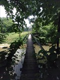 view gallery view gallery N5.1 km N5.1 km
|  Sheltowee Trace trail over Triplett Creek, KY Sheltowee Trace trail over Triplett Creek, KY
in Pedestrian Suspension Bridges About 800 feet south of US-60.
posted by: wuja location: Kentucky date approved: 06/17/2007 last visited: 07/25/2011 |
 view gallery view galleryN5.1 km |  Shelltowee Trace Footbridge triplett creek - Morehead, KY, US Shelltowee Trace Footbridge triplett creek - Morehead, KY, US
in Hiking Path Footbridges Limestone Connector #109A (1.7 miles) Begins at US 60 and travels south, crossing a swinging bridge over Triplett Creek, then ends at the Sheltowee Trace on Limestone Ridge. posted by: Crazy4horses location: Kentucky date approved: 04/26/2016 last visited: 04/27/2016 |
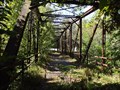 view gallery view galleryN5.3 km |  Old US 60 Iron Bridge - Freestone Road, KY, USA Old US 60 Iron Bridge - Freestone Road, KY, USA
in Truss Bridges This bridge was built in 1921 across Triplett Creek in Rowan County, Kentucky on what was then Route US 60 West of Morehead, KY. posted by: Simplenfun location: Kentucky date approved: 10/18/2011 last visited: 10/11/2016 |
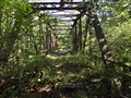 view gallery view galleryN5.3 km |  Old US 60 Iron Bridge - Freestone Road, KY, USA Old US 60 Iron Bridge - Freestone Road, KY, USA
in Orphaned Bridges This orphaned bridge is located in Rowan County, Kentucky west of Morehead on Freestone Road which used to be US 60. posted by: Simplenfun location: Kentucky date approved: 10/23/2016 last visited: 10/26/2016 |
 view gallery view gallery S5.5 km S5.5 km
|  Yale, KY, US Yale, KY, US
in Ghost Towns Yale Kentucky was a logging Town on Licking River. posted by: Crazy4horses location: Kentucky date approved: 08/30/2010 last visited: 02/13/2016 |
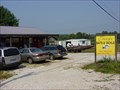 view gallery view galleryNW5.5 km |  Jerry's Baits and Tackle - Farmers Kentucky Jerry's Baits and Tackle - Farmers Kentucky
in Bait Shops Located 1.5 miles east of Farmers on US 60. posted by: Simplenfun location: Kentucky date approved: 01/18/2017 last visited: 10/11/2016 |
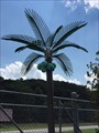 view gallery view galleryNW5.6 km |  Cave Run Bingo Electric Palm Trees - Farmers, KY, US Cave Run Bingo Electric Palm Trees - Farmers, KY, US
in Electric Palm Trees Located on east U.S. 60 out of farmers Kentucky. posted by: Crazy4horses location: Kentucky date approved: 08/02/2016 last visited: 10/10/2016 |
|