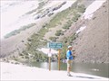
 view gallery view gallery NW7.7 km NW7.7 km
|   Twin Lake, Bridgeport, California Twin Lake, Bridgeport, California
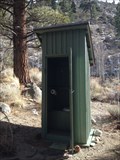
in Outhouses Rest Stop on the hill.. posted by:  grandmabetsy grandmabetsy location: California date approved: 03/02/2014 last visited: 03/02/2014 |
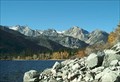 view gallery view galleryNW9.2 km |  Crag's Resort, Lower Twin Lake- Bridgeport, CA Crag's Resort, Lower Twin Lake- Bridgeport, CA
in Fishing Holes Lower Twin Lakes Crag's Resort, in large Jeffrey pine trees and sagebrush. Trophy trout are taken annually from Lower Twin Lake, one of the premier fishing lakes in Mono County. posted by:  calgriz calgriz location: California date approved: 01/21/2010 last visited: 07/10/2010 |
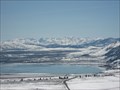 view gallery view gallery E10.1 km E10.1 km
|  Mono Diggins - Mono Lake, CA Mono Diggins - Mono Lake, CA
in Scenic Overlooks An AMAZING view of Mono Lake. posted by: bluesnote location: California date approved: 10/05/2010 last visited: 10/03/2015 |
 view gallery view galleryE10.1 km |  Mono Diggins - Mono Lake, CA Mono Diggins - Mono Lake, CA
in Scenic Roadside Look-Outs Awesome view off of 395. posted by: bluesnote location: California date approved: 04/21/2016 last visited: 06/22/2018 |
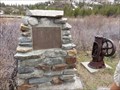
 view gallery view galleryE10.1 km |  Mono Diggins - Mono Lake, CA Mono Diggins - Mono Lake, CA
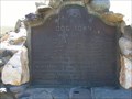
in E Clampus Vitus Historical Markers Awesome view off of 395. posted by: bluesnote location: California date approved: 05/20/2010 last visited: 05/31/2012 |
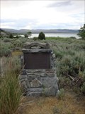
 view gallery view gallery NE11.7 km NE11.7 km
|  Dog Town Dog Town
in California Historical Markers California Historical Landmark #792 is located on Highway 395. posted by: Free2bme29 location: California date approved: 11/01/2009 last visited: 09/14/2021 |
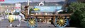
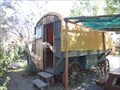 view gallery view galleryNE12.6 km |  Virginia Creek Settlement Wagon - Bridgeport, CA Virginia Creek Settlement Wagon - Bridgeport, CA
in Covered Wagons A covered wagon for rent! posted by: chrissyml location: California date approved: 07/09/2012 last visited: never |
 view gallery view gallery S14.8 km S14.8 km
|  Mount Conness Mount Conness
in Summit Registers At 12,590 feet, Mount Conness is the tallest peak in the Sierra Nevada North of Tioga Pass. posted by: Touchstone location: California date approved: 08/22/2007 last visited: never |
 view gallery view gallery SE15.8 km SE15.8 km
|  American Legion - Mono City, CA American Legion - Mono City, CA
in Veteran Cemeteries American Legion cemetery is located in Mono Lake, CA. posted by: tatie location: California date approved: 10/22/2013 last visited: 10/30/2018 |
 view gallery view gallery N17.7 km N17.7 km
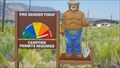
|  Smokey - Rt. 395 - CA Smokey - Rt. 395 - CA
in Smokey Bear Sign Sightings Smokey is locted on Rt. 395 - CA. posted by: tatie location: California date approved: 10/21/2013 last visited: never |
 view gallery view galleryS18 km | Bennettville - Yosemite NP, California in E Clampus Vitus Historical Markers Reason why the Tioga Road was built posted by: jimnade location: California date approved: 06/13/2015 last visited: never |
 view gallery view galleryS18 km |  The Tioga Pass Road - Lee Vining CA- Elevation 9945' The Tioga Pass Road - Lee Vining CA- Elevation 9945'
in Elevation Signs The Tioga Pass Road Constructed 1883 & 1910. Tioga Pass at 9945 feet is the highest automobile pass in California. The road to the pass was constructed in two parts. posted by: Don.Morfe location: California date approved: 08/10/2020 last visited: 10/30/2021 |
 view gallery view galleryN18.3 km |  Bull & Horse in Bridgeport, CA Bull & Horse in Bridgeport, CA
in Fiberglass Horses A bull and a horse in front of a local motel in Bridgeport, California posted by: Bernd das Brot Team location: California date approved: 09/14/2006 last visited: 07/06/2012 |
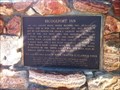 view gallery view galleryN18.3 km | Bridgeport Inn - Bridgeport, CA in E Clampus Vitus Historical Markers A plaque outside an antique hotel in Bridgeport, CA. posted by: chrissyml location: California date approved: 03/29/2013 last visited: never |
 view gallery view galleryN18.5 km |  Mono County Courthouse - Bridgeport, California Mono County Courthouse - Bridgeport, California
in U.S. National Register of Historic Places Building - #74000536. Imposing Italianate structure on Main Street. posted by: Squirreleen location: California date approved: 04/30/2008 last visited: 02/14/2014 |
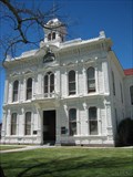 view gallery view galleryN18.5 km |  Mono County Courthouse - Bridgeport, California Mono County Courthouse - Bridgeport, California
in Courthouses The Mono County Courthouse. posted by: Squirreleen location: California date approved: 04/30/2008 last visited: 02/14/2014 |
 view gallery view galleryS18.5 km | Yosemite - Ellery Lake in Elevation Signs Ellery Lake at the Tioga Pass near the east entrance of Yosemite. posted by: eveningrose location: California date approved: 08/15/2010 last visited: 05/14/2013 |
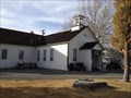 view gallery view galleryN18.5 km |  Bridgeport Elementary school Bridgeport Elementary school
in Former Schools The School is now the Mono County Museum. posted by: grandmabetsy location: California date approved: 03/03/2014 last visited: 06/22/2018 |
 view gallery view galleryN18.5 km |  Bridgeport school/Mono County Museum, Bridgeport, Ca Bridgeport school/Mono County Museum, Bridgeport, Ca
in Relocated Structures This is the original Bridgeport Elementary School posted by: grandmabetsy location: California date approved: 03/02/2014 last visited: 06/19/2021 |
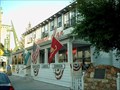 view gallery view galleryN18.5 km |  The Bridgeport Inn, Bridgeport, CA, USA The Bridgeport Inn, Bridgeport, CA, USA
in Antique Hotels The Bridgeport Inn, Bridgeport, California, USA posted by: michael3900 location: California date approved: 09/26/2008 last visited: 02/14/2014 |
 view gallery view gallerySE19.2 km | Sheriff James P. Dolan in E Clampus Vitus Historical Markers Located at the Mono Lake Tufa State Natural Reserve. Found this while visiting the tufa. The marker is at the entrance to the parking lot of the picnic area. posted by: fresgo location: California date approved: 07/13/2010 last visited: 10/30/2018 |
 view gallery view gallerySE20.8 km |  Gardening for birds and butterflies - Mono Basin, CA Gardening for birds and butterflies - Mono Basin, CA
in Butterfly Gardens Gardening for birds and butterflies is located in Mono Lake, CA. posted by: tatie location: California date approved: 10/21/2013 last visited: 03/02/2014 |
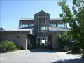 view gallery view gallerySE20.8 km |  Mono Basin Visitor Center - Lee Vining, CA Mono Basin Visitor Center - Lee Vining, CA
in Ranger Stations This big center have info on Mono Lake and the surrounding area. It's located on highway 395 just outside of Lee Vining. posted by: Free2bme29 location: California date approved: 07/24/2009 last visited: 10/30/2018 |
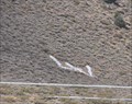 view gallery view gallerySE21.4 km |  LV for Lee Vining LV for Lee Vining
in Letters on Hills The 'LV' representing the town of Lee Vining is located on a hillside on the west side of central Lee Vining, California. posted by: brwhiz location: California date approved: 02/25/2013 last visited: 10/30/2018 |
 view gallery view gallerySE21.4 km | Upside - Down House in E Clampus Vitus Historical Markers A house built upside down, from outside structure to inside furnishings. Inspired by children's books. Marker is in Lee Vining, California, 93541 in Mono County. posted by: FindersKeepersLTD location: California date approved: 09/05/2008 last visited: 02/14/2014 |
|