 view gallery view gallery S4.2 km S4.2 km
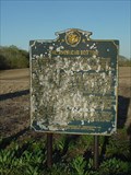
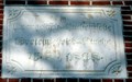
|   The American Bottom The American Bottom
in Illinois Historical Markers Historical marker describing the rich soil and history of the area.
posted by:  paulspaper paulspaper location: Illinois date approved: 08/27/2007 last visited: 03/28/2014 |
 view gallery view gallery N10.3 km N10.3 km
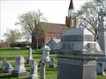
|  Trinity Lutheran Church and Cemetery - Redbud (Prairie), Illinois Trinity Lutheran Church and Cemetery - Redbud (Prairie), Illinois
in Churchyard Cemeteries Historic country Lutheran Church and cemetery near Redbud, Illinois. posted by:  BruceS BruceS location: Illinois date approved: 05/04/2009 last visited: 02/13/2014 |
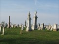 view gallery view galleryN10.3 km |  Trinity Lutheran Cemetery - Redbud (Prairie), Illinois Trinity Lutheran Cemetery - Redbud (Prairie), Illinois
in Worldwide Cemeteries Cemetery adjacent to country Lutheran church near Redbud, Illinois. posted by: BruceS location: Illinois date approved: 05/02/2009 last visited: 02/13/2014 |
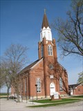 view gallery view galleryN10.3 km |  Trinity Lutheran Church - Redbud (Prairie), Illinois Trinity Lutheran Church - Redbud (Prairie), Illinois
in Lutheran Churches Historic country Lutheran Church near Redbud, Illinois. posted by: BruceS location: Illinois date approved: 05/02/2009 last visited: 02/13/2014 |
 view gallery view galleryN10.3 km |  1868 - Trinity Lutheran Church - Redbud (Prairie), Illinois 1868 - Trinity Lutheran Church - Redbud (Prairie), Illinois
in Dated Buildings and Cornerstones Historic country Lutheran Church near Redbud, Illinois. posted by: BruceS location: Illinois date approved: 05/04/2009 last visited: never |
 view gallery view galleryN10.3 km | Trinity Lutheran Church - Redbud (Prairie), Illinois in This Old Church Historic country Lutheran Church near Redbud, Illinois. posted by: BruceS location: Illinois date approved: 05/02/2009 last visited: 02/13/2014 |
 view gallery view galleryN10.3 km | Trinity Lutheran Church - Redbud (Prairie), Illinois in Country Churches Historic country Lutheran Church near Redbud, Illinois. posted by: BruceS location: Illinois date approved: 05/05/2009 last visited: never |
 view gallery view gallery SW11.4 km SW11.4 km
|  N 38 W 90 - Near Flinton, IL N 38 W 90 - Near Flinton, IL
in Confluence Spots This confluence point lies in the Mississippi River floodplain of Southern Illinois. Near Chester, IL and Sainte Genevieve, MO posted by: Cap'n YB location: Illinois date approved: 12/22/2007 last visited: 12/19/2007 |
 view gallery view gallery E11.7 km E11.7 km
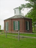
|  Charter Oak "8-Sided" School - Schuline, Illinois Charter Oak "8-Sided" School - Schuline, Illinois
in Official Local Tourism Attractions This building is a study in physics as well as history as it was designed to withstand strong winds and capture light throughout the day. posted by: paulspaper location: Illinois date approved: 05/04/2008 last visited: 03/24/2014 |
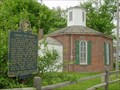 view gallery view galleryE11.7 km | Charter Oak School in Illinois Historical Markers Octagonal brick schoolhouse built in 1873. posted by: paulspaper location: Illinois date approved: 05/04/2008 last visited: never |
 view gallery view galleryE11.7 km |  Charter Oak Schoolhouse Charter Oak Schoolhouse
in U.S. National Register of Historic Places Octagonal brick schoolhouse built in 1873. Located between Schuline and Walsh in a nice shaded area. posted by: paulspaper location: Illinois date approved: 05/04/2008 last visited: 03/24/2014 |
 view gallery view galleryE11.7 km |  Charter Oak School Charter Oak School
in Octagon Buildings Octagonal brick schoolhouse built in 1873. posted by: paulspaper location: Illinois date approved: 05/04/2008 last visited: 03/24/2014 |
 view gallery view galleryE11.7 km |  Charter Oak School Charter Oak School
in Former Schools Octagonal brick schoolhouse built in 1873. Located between Walsh and Schuline, Illinois. posted by: paulspaper location: Illinois date approved: 05/04/2008 last visited: 03/24/2014 |
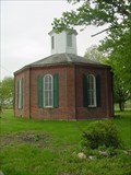 view gallery view galleryE12.7 km |  Charter Oak "8-Sided" School - Schuline, Illinois Charter Oak "8-Sided" School - Schuline, Illinois
in One-Room Schoolhouses Octagonal brick schoolhouse built in 1873. Very charming building in a nice rural location. posted by: paulspaper location: Illinois date approved: 02/03/2022 last visited: never |
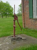 view gallery view galleryE12.7 km |  Charter Oak School Water Pump - Schuline, IL Charter Oak School Water Pump - Schuline, IL
in Hand Operated Water Pumps Old water pump at the Charter Oak School in Schuline, Illinois. posted by: paulspaper location: Illinois date approved: 02/20/2022 last visited: never |
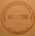 view gallery view galleryS13.5 km |  Lewis & Clark National Historic Trail - Ft. Kaskaskia, IL Lewis & Clark National Historic Trail - Ft. Kaskaskia, IL
in NPS Passport Cancellation Stations Between May 1804 and September 1806, 31 men, one woman, and a baby traveled from the plains of the Midwest to the shores of the Pacific Ocean. They called themselves the Corps of Discovery. In their search for a water route to the Pacific Ocean, they opened a window onto the west for the young United States. posted by: nomadwillie location: Illinois date approved: 10/30/2008 last visited: 08/19/2005 |
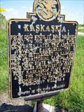 view gallery view galleryS13.7 km | Kaskaskia - Ellis Grove, IL in Illinois Historical Markers Second settlement in Illinois, The Territorial Capital and First State Capital posted by: kodiak_62 location: Illinois date approved: 08/21/2008 last visited: 08/23/2008 |
 view gallery view galleryS13.7 km | ") Lewis and Clark NHT - Fort Kaskaskia, IL Lewis and Clark NHT - Fort Kaskaskia, IL
in National Parks (U.S.) Between May 1804 and September 1806, 31 men, one woman, and a baby traveled from the plains of the Midwest to the shores of the Pacific Ocean posted by: nomadwillie location: Illinois date approved: 02/10/2009 last visited: 09/17/2011 |
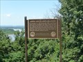
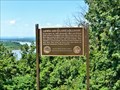
 view gallery view galleryS13.7 km |  A Vanished Capital - near Chester IL A Vanished Capital - near Chester IL
in Scenic Roadside Look-Outs A Vanished Capital, view of the location of Illinois 1st State Capital, Kaskakia. posted by: kJfishman location: Illinois date approved: 10/03/2011 last visited: 10/01/2011 |
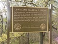 view gallery view galleryS13.7 km |  Lewis and Clark in Illinois - Fort Kaskaskia, Illinois Lewis and Clark in Illinois - Fort Kaskaskia, Illinois
in Lewis and Clark Trail Lewis and Clark visited here during preparations before departing west. posted by: paulspaper location: Illinois date approved: 08/28/2007 last visited: 05/20/2011 |
 view gallery view galleryS13.7 km | Lewis and Clark in Illinois - Ellis Grove, IL in Illinois Historical Markers Located at Fort Kaskaskia right outside the pavillion overlooking the Mississippi River posted by: nomadwillie location: Illinois date approved: 02/24/2013 last visited: never |
 S13.7 km |  To a Sunken City To a Sunken City
in Weird Story Locations A city sunken, and a state divided by a possible indian curse... posted by:  rockey_f_squirrell rockey_f_squirrell location: Illinois date approved: 08/18/2005 last visited: 06/18/2011 |
 view gallery view gallery W13.8 km W13.8 km
|  Mobil Gas Pumps - Prairie du Rocher, Illinois Mobil Gas Pumps - Prairie du Rocher, Illinois
in Vintage Gasoline Pumps Vintage Mobil gas pumps in Prairie du Rocher, Illinois. posted by: paulspaper location: Illinois date approved: 04/09/2008 last visited: never |
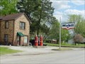 view gallery view galleryW13.8 km |  Mobil Gas Station - Prairie du Rocher, Illinois Mobil Gas Station - Prairie du Rocher, Illinois
in Vintage Gas Stations Old Mobil gas station in Prairie du Rocher, Illinois. posted by: paulspaper location: Illinois date approved: 04/08/2008 last visited: never |
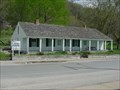 view gallery view galleryW13.8 km |  Creole House - Prairie du Rocher, Illinois Creole House - Prairie du Rocher, Illinois
in Pre-Victorian Historic Homes The Creole House is unique in architecture because it used the French "post in ground" style. The home was built in 1800. posted by: paulspaper location: Illinois date approved: 05/03/2008 last visited: never |
|