 view gallery view gallery NW20.6 km NW20.6 km
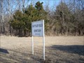
|   Battlefield Cemetery - rural Linn County, Kansas, USA Battlefield Cemetery - rural Linn County, Kansas, USA
in Worldwide Cemeteries This small cemetery is located 1 mile south of the Mine Creek Battlefield on East 700 Road in Rural Linn County, Kansas. posted by:  iconions iconions location: Kansas date approved: 07/24/2017 last visited: never |
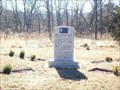 view gallery view galleryNW21.4 km |  Battle of Mine Creek Confederate Dead Memorial - Pleasanton, Kansas Battle of Mine Creek Confederate Dead Memorial - Pleasanton, Kansas
in American Civil War Monuments and Memorials This is the only Confederate memorial on Kansas soil. posted by: iconions location: Kansas date approved: 03/01/2008 last visited: 02/07/2016 |
 view gallery view gallery SE21.4 km SE21.4 km
|  Giant Morel Mushroom, Nevada, Missouri Giant Morel Mushroom, Nevada, Missouri
in Roadside Attractions It is rather surprising to see such a large mushroom, sprouting alongside the highway! posted by: Queens Blessing location: Missouri date approved: 06/25/2011 last visited: 02/14/2015 |
 view gallery view gallerySE21.4 km |  MOREL- Nevada, Missouri MOREL- Nevada, Missouri
in Ginormous Everyday Objects This huge Morel is located just north of Nevada, Missouri posted by:  GEO*Trailblazer 1 GEO*Trailblazer 1 location: Missouri date approved: 12/01/2007 last visited: 08/20/2011 |
 view gallery view galleryNW21.7 km | Battle of Mine Creek - Pleasanton, Kansas in Civil War Discovery Trail Sites This was the only Civil War battle fought between regular units of Union and Confederate forces on Kansas soil. posted by: iconions location: Kansas date approved: 03/03/2008 last visited: 03/11/2013 |
 view gallery view galleryNW21.7 km |  Battle of Mine Creek - Pleasanton, Kansas Battle of Mine Creek - Pleasanton, Kansas
in Battlefields This was the only Civil War battle fought between regular Union and Confederate forces on Kansas soil. posted by: iconions location: Kansas date approved: 03/03/2008 last visited: 03/11/2013 |
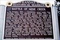
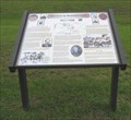
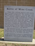 view gallery view galleryNW21.7 km |  Battle of Mine Creek -- nr Pleasanton KS Battle of Mine Creek -- nr Pleasanton KS
in Kansas Historical Markers The grey granite historic marker at the Mine Creek Battlefield near Pleasanton KS commemorating the Civil War battle that occurred here on 25 Oct 1864. posted by: Benchmark Blasterz location: Kansas date approved: 03/27/2013 last visited: 02/07/2016 |
 view gallery view galleryNW21.7 km |  LARGEST Civil War Battle in KS -- nr Pleasanton KS LARGEST Civil War Battle in KS -- nr Pleasanton KS
in Superlatives The site of the Civil War Battle of Mine Creek, in which 2500 Union troops defeated 8000 Confederates in the largest Civil War battle to occur in KS. posted by: Benchmark Blasterz location: Kansas date approved: 03/27/2013 last visited: 02/07/2016 |
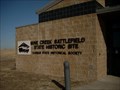
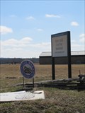
 view gallery view galleryNW21.9 km | Battle of Mine Creek in Kansas Historical Markers In front of the visitor center at Mine Creek Battlefield State Historic Site. posted by: Markerman62 location: Kansas date approved: 04/06/2015 last visited: 04/08/2015 |
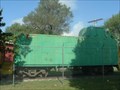 view gallery view galleryNW22.4 km |  BURLINGTON CABOOSE # 13551 BURLINGTON CABOOSE # 13551
in Train Cabooses Burlingtom Northern Caboose Pleasanton Kansas posted by: GEO*Trailblazer 1 location: Kansas date approved: 12/04/2007 last visited: 12/04/2007 |
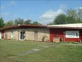
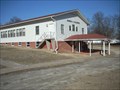
 view gallery view galleryNW22.4 km |  LINN COUNTY - Museum LINN COUNTY - Museum
in History Museums Linn County Kansas Historical Museum and Genalogy Library Pleasanton, Kansas posted by: GEO*Trailblazer 1 location: Kansas date approved: 01/18/2008 last visited: 01/18/2008 |
 view gallery view galleryNW22.4 km |  Trading Post URR Linn County Kansas Trading Post URR Linn County Kansas
in Underground Railroad Sites Trading Post "Pleasanton" Kansas one of the 1st URR Sites posted by: GEO*Trailblazer 1 location: Kansas date approved: 12/05/2007 last visited: 12/05/2007 |
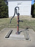 view gallery view galleryNW22.5 km |  Pleasanton Cemetery Pump -- Pleasanton KS Pleasanton Cemetery Pump -- Pleasanton KS
in Hand Operated Water Pumps An old hand-operated water pump outside of the chapel in the center of Pleasanton Cemetery on the outskirts of Pleasanton KS. posted by: Benchmark Blasterz location: Kansas date approved: 03/27/2013 last visited: 03/11/2013 |
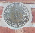 view gallery view galleryNW22.5 km |  NGS Benchmark JE0734 - Pleasanton, Kansas NGS Benchmark JE0734 - Pleasanton, Kansas
in U.S. Benchmarks This Benchmark is the wall of a former bank building (now a medical clinic) at 10th and Main in Downtown Pleasanton, Kansas. posted by: iconions location: Kansas date approved: 03/06/2008 last visited: 03/11/2013 |
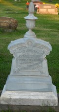 view gallery view galleryNW22.5 km |  Lydia Jane Harris - Pleasanton Cemetery - Pleasanton, Ks. Lydia Jane Harris - Pleasanton Cemetery - Pleasanton, Ks.
in Zinc Headstones This two-sided zinc marker is located in the Pleasanton Cemetery - 17th Street 1/4 mile west of Laurel Street. posted by: iconions location: Kansas date approved: 10/25/2009 last visited: 03/11/2013 |
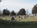 view gallery view galleryNW22.7 km | Pleasanton Cemetery -- Pleasanton KS in Worldwide Cemeteries The Pleasanton Cemetery on the outskirts of Pleasanton KS has been serving this community since the 1870s. posted by: Benchmark Blasterz location: Kansas date approved: 03/29/2013 last visited: 03/11/2013 |
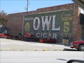 view gallery view galleryNW22.7 km |  Owl Cigar -- Pleasanton KS Owl Cigar -- Pleasanton KS
in Ghost Signs The ghost sign for Owl Cigars, still only 5 cents, on Main Street in downtown Pleasanton KS posted by: Benchmark Blasterz location: Kansas date approved: 03/27/2013 last visited: 03/11/2013 |
 view gallery view galleryNW22.9 km |  Pleasanton, Kansas Pleasanton, Kansas
in Church of the Nazarene This Church of the Nazarene is located at 1012 Laurel St in Pleasanton, Kansas posted by: iconions location: Kansas date approved: 03/01/2008 last visited: never |
 view gallery view galleryNW22.9 km |  PLEASONTON - Water Tank PLEASONTON - Water Tank
in Water Towers Pleasonton Kansas on General Pleasonton Day 2007 posted by: GEO*Trailblazer 1 location: Kansas date approved: 11/13/2007 last visited: 03/11/2013 |
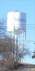 view gallery view galleryNW22.9 km | NGS Benchmark JE1926 - Pleasanton, Ks in U.S. Benchmarks This is the Pleasanton Water Tank that sits on top of the hill west of town. posted by: iconions location: Kansas date approved: 12/30/2008 last visited: 03/11/2013 |
 view gallery view gallery S23 km S23 km
|  Battles in the Marmaton Valley, Vernon County, Missouri Battles in the Marmaton Valley, Vernon County, Missouri
in Missouri Historical Markers This sign provides the history behind the American Civil War battle at Marmaton Valley. posted by: Queens Blessing location: Missouri date approved: 05/31/2010 last visited: 09/15/2012 |
 view gallery view gallery E24.3 km E24.3 km
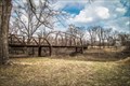
|  Papinville Marais des Cygnes River Bridge – Papinville, Missouri Papinville Marais des Cygnes River Bridge – Papinville, Missouri
in Orphaned Bridges Historic truss bridge over the Marais des Cygnes River near Papinville, Missouri. posted by:  BruceS BruceS location: Missouri date approved: 03/26/2015 last visited: never |
 view gallery view galleryE24.3 km |  Papinville Marais des Cygnes River Bridge – Papinville, Missouri Papinville Marais des Cygnes River Bridge – Papinville, Missouri
in Truss Bridges Historic truss bridge over the Marais des Cygnes River near Papinville, Missouri. posted by: BruceS location: Missouri date approved: 03/25/2015 last visited: never |
 view gallery view galleryE24.3 km |  Papinville Marais des Cygnes River Bridge – Papinville, Missouri Papinville Marais des Cygnes River Bridge – Papinville, Missouri
in U.S. National Register of Historic Places Historic truss bridge over the Marais des Cygnes River near Papinville, Missouri. posted by: BruceS location: Missouri date approved: 03/26/2015 last visited: never |
 view gallery view gallerySE24.6 km | Infirmary Building, Missouri State Hospital Number 3 – Nevada, Missouri in U.S. National Register of Historic Places Historic former infirmary building for state hospital in Nevada Missouri posted by: BruceS location: Missouri date approved: 03/26/2015 last visited: never |
|