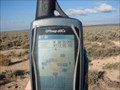
 view gallery view gallery E37.8 km E37.8 km
|   N 38° W 113° N 38° W 113°
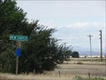
in Confluence Spots A short ( less than 500 feet ) walk from the highway through the
sagebrush will bring you to this confluence spot. posted by:  JacobBarlow JacobBarlow location: Utah date approved: 10/17/2007 last visited: 10/23/2016 |
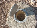 view gallery view galleryE38 km |  Benchmark: JO0411 " Q 369 " Benchmark: JO0411 " Q 369 "
in U.S. Benchmarks Easy to find, just off the highway. posted by: JacobBarlow location: Utah date approved: 10/19/2007 last visited: 10/23/2016 |
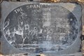 view gallery view gallery S38.1 km S38.1 km
|  The Spanish Trail ~ 1800-1850 The Spanish Trail ~ 1800-1850
in Utah Historical Markers This marker was placed where the Old Spanish Trail crosses Utah Highway 56 just east of New Castle, Utah. posted by: brwhiz location: Utah date approved: 05/18/2012 last visited: never |
 view gallery view galleryS38.1 km |  The Spanish Trail The Spanish Trail
in Wagon Roads and Trails This marker is located where the Old Spanish Trail crosses Utah Highway 56 just east of New Castle, Utah. posted by: brwhiz location: Utah date approved: 04/19/2012 last visited: never |
 view gallery view gallery SW38.5 km SW38.5 km
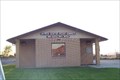
|  Pioneer Park - Beryl Junction, UT Pioneer Park - Beryl Junction, UT
in Municipal Parks and Plazas This modest park contains little other than a shelter and a monument - in Beryl Junction, Utah. posted by: The Snowdog location: Utah date approved: 01/01/2023 last visited: never |
 view gallery view galleryS38.8 km |  New Castle, Utah New Castle, Utah
in Wikipedia Entries I was surprised little New Castle even has a page, but there's not much to it yet. posted by: JacobBarlow location: Utah date approved: 02/01/2008 last visited: 02/12/2011 |
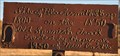 view gallery view galleryS38.8 km | Site of Blacksmith Shop on Spanish Trail in Utah Historical Markers This rather primitive historic marker is comprised of free-hand script welding on a steel plate. posted by: brwhiz location: Utah date approved: 04/19/2012 last visited: never |
 view gallery view galleryS38.8 km |  New Castle, UT 84756 New Castle, UT 84756
in U.S. Post Offices New Castle, Utah 84756 posted by: PeanutsParents location: Utah date approved: 09/30/2007 last visited: 09/17/2011 |
 view gallery view galleryE39.8 km | Benchmark: JO0408 " M 369 " in U.S. Benchmarks Easily found, right off the road. posted by: JacobBarlow location: Utah date approved: 10/19/2007 last visited: 10/20/2007 |
 view gallery view galleryE40.4 km | Parowan Gap Petroglyphs in Utah Historical Markers This older, rather nondescript historical marker is one of two at the petroglyphs in Parowan Gap. posted by: brwhiz location: Utah date approved: 04/07/2012 last visited: 10/22/2019 |
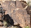 view gallery view galleryE40.7 km |  Parowan Gap Petroglyphs Parowan Gap Petroglyphs
in Pictographs The Parowan Gap Petroglyphs were officially "discovered" by a group from the Southern Expedition of 1849 under the leadership of David Fullmer. posted by: brwhiz location: Utah date approved: 04/07/2012 last visited: 10/22/2019 |
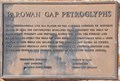 view gallery view galleryE40.7 km |  Parowan Gap Petroglyphs Marker Parowan Gap Petroglyphs Marker
in Eagle Scout Project Sites Eagle Scout Alva Metheson has provided a nice historical marker for the interesting pictographs at Parowan Gap. posted by: brwhiz location: Utah date approved: 04/08/2012 last visited: 10/20/2019 |
 view gallery view galleryE40.7 km | Parowan Gap Petroglyphs - Eagle Scout Marker in Utah Historical Markers An Eagle Scout Project has provided a nice historical marker for these interesting pictographs. posted by: brwhiz location: Utah date approved: 04/08/2012 last visited: 10/22/2019 |
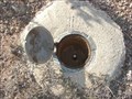 view gallery view galleryE41.2 km | Benchmark: JO0407 " L 369 " in U.S. Benchmarks Found easily, right off the highway. posted by: JacobBarlow location: Utah date approved: 10/19/2007 last visited: 10/20/2007 |
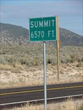 view gallery view galleryE41.7 km |  Summit 6570 HWY 130 Summit 6570 HWY 130
in Elevation Signs The summit along HWY 130 between Cedar City and Minersville, the Elevation is 6,570 feet above Sea Level. posted by: JacobBarlow location: Utah date approved: 11/01/2007 last visited: 09/29/2011 |
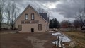 view gallery view gallery SE43.5 km SE43.5 km
|  Old School Library - Enoch, UT Old School Library - Enoch, UT
in Libraries The Old School Library serves Enoch, Utah. posted by: The Snowdog location: Utah date approved: 01/02/2023 last visited: never |
 view gallery view gallerySE43.5 km | Old Spanish Trail Marker - Enoch, UT in Eagle Scout Project Sites This project updated a historic marker originally created by a Boy Scout troop in 1948. posted by: rjmcdonough1 location: Utah date approved: 09/06/2019 last visited: never |
 view gallery view gallerySE43.5 km | Old Spanish Trail - Enoch, UT in Utah Historical Markers This marker was originally created in 1948. posted by: rjmcdonough1 location: Utah date approved: 10/12/2019 last visited: never |
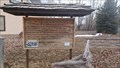
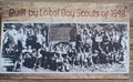 view gallery view gallerySE43.5 km |  Old Spanish Trail Sign - Enoch, Utah Old Spanish Trail Sign - Enoch, Utah
in Photos Then and Now This sign was erected by the Boy Scouts in 1948, and exhibits a photograph of the then-new sign - in Enoch, Utah. posted by: The Snowdog location: Utah date approved: 01/02/2023 last visited: never |
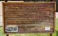
 view gallery view gallerySE43.5 km | First Wagons on the Old Spanish Trail - Enoch, UT in Wagon Roads and Trails The first wagon to enter Iron County on the Old Spanish Trail arrived in 1848 - in Enoch, Utah. posted by: The Snowdog location: Utah date approved: 01/03/2023 last visited: never |
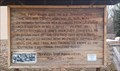 view gallery view gallerySE43.5 km |  First Wagon on the Old Spanish Trail - 100 Years - Enoch, UT First Wagon on the Old Spanish Trail - 100 Years - Enoch, UT
in Commercial Commemorations This sign, created by the Boy Scouts in 1948, commemorates the arrival of the first wagons on the Old Spanish Trail one hundred years earlier - in Enoch, Utah. posted by: The Snowdog location: Utah date approved: 01/23/2023 last visited: never |
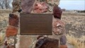
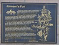 view gallery view gallerySE43.8 km |  Johnson's Fort ~ 461 Johnson's Fort ~ 461
in D.U.P. Historic Markers Johnson's Fort was one of the earliest fortified settlements in southwestern Utah. posted by: brwhiz location: Utah date approved: 01/16/2012 last visited: never |
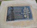
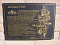 view gallery view gallerySE43.8 km | Johnson's Fort in Utah Historical Markers During the summer of 1851, a small company of men was exploring this area and discovered the springs on the bench one-fourth mile to the east.... posted by: JacobBarlow location: Utah date approved: 10/02/2007 last visited: 01/29/2011 |
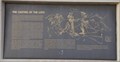 view gallery view gallerySE43.9 km | The Casting of the Lots in Utah Historical Markers This marker is some eleven miles south of where the final decision was reached for the Dominguez y Escalante exploration party to return to Santa Fe instead of pressing onward to Monterey. posted by: brwhiz location: Utah date approved: 04/19/2012 last visited: never |
 view gallery view gallerySE44.1 km | Enoch Schoolhouse and Tithing Office in Utah Historical Markers The second schoolhouse in Enoch was a two-story structure built on this site in 1917-1918. It was a brick building containing two classrooms, two libraries, two bathrooms and a furnace room....
posted by: JacobBarlow location: Utah date approved: 10/02/2007 last visited: 01/29/2011 |
|