 view gallery view gallery E6 km E6 km
|   Frenchburg School Campus - Frenchburg, KY USA Frenchburg School Campus - Frenchburg, KY USA
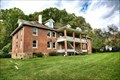
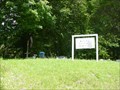
in Unoccupied Buildings, Shacks, and Cabins Multilple buildings on the Frenchburg School Campus are unoccupied and abandoned. For many years since 1909 it provided the only high school educational opportunities in the area. posted by:  nomadwillie nomadwillie location: Kentucky date approved: 01/03/2022 last visited: never |
 view gallery view galleryE6 km |  Frenchburg School Campus - Frenchburg KY Frenchburg School Campus - Frenchburg KY
in Former Schools The Frenchburg School, a mission enterprise sponsored by the United Presbyterian Church, since 1909 it provided the only high school educational opportunities in the area. Today it is vacant and abandoned. posted by: nomadwillie location: Kentucky date approved: 12/29/2021 last visited: never |
 view gallery view galleryE6 km |  Frenchburg School Campus - Frenchburg KY Frenchburg School Campus - Frenchburg KY
in U.S. National Register of Historic Places The Frenchburg School Campus, located on U.S. Route 460 in Frenchburg, Kentucky, was built in 1909. It was listed on the National Register of Historic Places in 1978. It included six contributing buildings on 12 acres. posted by: nomadwillie location: Kentucky date approved: 12/31/2021 last visited: never |
 view gallery view galleryE6 km |  Frenchburg School Campus - Frenchburg KY Frenchburg School Campus - Frenchburg KY
in Wikipedia Entries The Frenchburg School Campus, located on U.S. Route 460 in Frenchburg, Kentucky, was built in 1909. It was listed on the National Register of Historic Places in 1978. It included six contributing buildings on 12 acres. posted by: nomadwillie location: Kentucky date approved: 12/29/2021 last visited: never |
 view gallery view galleryE6.9 km |  Mail Pouch Tobacco Barn - Frenchburg, KY, US Mail Pouch Tobacco Barn - Frenchburg, KY, US
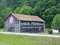
in Barns Located on Old Beaver Rd. posted by: Crazy4horses location: Kentucky date approved: 04/20/2016 last visited: 11/26/2010 |
 view gallery view gallery NE12.1 km NE12.1 km
|  Clear Creek Shooting Range Clear Creek Shooting Range
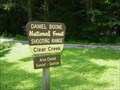
in Shooting Ranges The Clear Creek Shooting Range is an outdoor range located in the Daniel Boone National Forest, and operated by the U.S. Forest Service. It is one of the four shooting ranges on the Daniel Boone National Forest. All ranges are open year round. posted by: Simplenfun location: Kentucky date approved: 08/10/2011 last visited: 10/11/2016 |
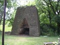
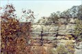
 view gallery view galleryNE12.7 km |  Clear Creek Furnace, Kentucky Clear Creek Furnace, Kentucky
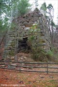
in Ovens and Kilns This is one of several old iron furnaces in Kentucky. posted by: Simplenfun location: Kentucky date approved: 08/10/2008 last visited: 10/11/2016 |
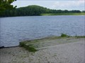 view gallery view galleryNE12.7 km |  Clear Creek Lake Boat Ramp Clear Creek Lake Boat Ramp
in Boat Ramps Clear Creek Lake is 40 acres with only electric motors allowed. The ramp is open year-round 24 hours. posted by: Simplenfun location: Kentucky date approved: 08/14/2011 last visited: 10/11/2016 |
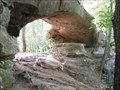
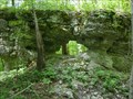 view gallery view galleryNE13.4 km |  Zilpo Arch, DBNF Kentucky Zilpo Arch, DBNF Kentucky
in Natural Arches Zilpo Arch is a small arch located in the Daniel Boone National Forest, and easily accessible from the road where there is a pulloff area for parking. posted by: Simplenfun location: Kentucky date approved: 09/12/2011 last visited: 10/11/2016 |
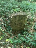
 view gallery view galleryNE13.4 km |  White Sulphur Cemetery White Sulphur Cemetery
in Worldwide Cemeteries This is a very small cemetery located near Salt Lick, Kentucky, USA. There are approximately 25 graves here. posted by: Simplenfun location: Kentucky date approved: 08/15/2011 last visited: 10/11/2016 |
 view gallery view galleryNE15.3 km | Lower Salt Lick Cemetery - Salt Lick, KY, US in Worldwide Cemeteries Located on South Hwy 211. Cemetery is approximately 1.5 miles. Turn right on small gravel road just before little blue house. posted by: Crazy4horses location: Kentucky date approved: 12/20/2016 last visited: 12/20/2016 |
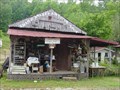 view gallery view gallery SE15.4 km SE15.4 km
|  Swamp Valley Antiques - Denniston Kentucky Swamp Valley Antiques - Denniston Kentucky
in Antique Shops About eight miles east of Frenchburg, posted by: Crazy4horses location: Kentucky date approved: 04/28/2016 last visited: 04/28/2016 |
 view gallery view galleryNE16.1 km |  Bath County High Point, KY, US Bath County High Point, KY, US
in Geographic High Points Located in Daniel Boone Nation Forest on Zilpo Scenic Drive. posted by: Crazy4horses location: Kentucky date approved: 01/04/2017 last visited: 01/04/2017 |
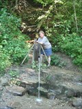
 view gallery view galleryNE16.3 km |  Tater Knob Spring - Bath County, KY, US Tater Knob Spring - Bath County, KY, US
in Natural Springs Located on Tater Knob Trail #104 posted by: Crazy4horses location: Kentucky date approved: 12/27/2016 last visited: 12/28/2016 |
 view gallery view gallery N16.6 km N16.6 km
|  Bourban Iron Works (Slate Creek Furnace) Bourban Iron Works (Slate Creek Furnace)
in Iron Furnace Ruins Old furnace in Central KY posted by:  kbarhow kbarhow location: Kentucky date approved: 06/30/2007 last visited: 06/11/2021 |
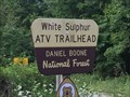 view gallery view galleryNE16.7 km |  White Sulphur ATV Trial - Salt Lick, KY, US White Sulphur ATV Trial - Salt Lick, KY, US
in Offroad Trails From I-64 East, take exit 123. Travel east on KY 60 and turn right on KY 211 to Salt Lick.
From KY 211, turn left onto Forest Service Road 129. Just past the Clear Creek Country Store, turn left onto Forest Service Road 105 posted by: Crazy4horses location: Kentucky date approved: 08/03/2016 last visited: 10/10/2016 |
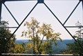
 view gallery view gallery S17.2 km S17.2 km
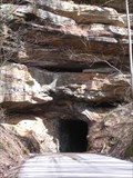
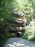
|  Nada Tunnel Nada Tunnel
in Abandoned Train Tunnels Nice old tunnel that you can drive through. It is like going through a doorway to a hidden gem. posted by: kbarhow location: Kentucky date approved: 03/17/2007 last visited: 05/09/2009 |
 view gallery view galleryS17.2 km |  Red River Gorge Scenic Byway - KY, US Red River Gorge Scenic Byway - KY, US
in National Scenic Byways The Red River Gorge Scenic Byway follows KY11, KY715, and KY15 from Stanton to Zachariah. posted by: Crazy4horses location: Kentucky date approved: 05/03/2016 last visited: 05/03/2016 |
 view gallery view galleryS17.4 km | Princess Arch at Red River Gorge in Natural Arches The Red River Gorge Geological Area has over 100 natural arches, the greatest concentration of arches east of the Rocky Mountains. Although Princess Arch is not the largest,it is well worth the short hike to see its beauty. posted by: Simplenfun location: Kentucky date approved: 09/12/2011 last visited: 10/11/2016 |
 view gallery view galleryS17.4 km | Nada Spring - Powell county, Ky, US in Natural Springs Located at the entrance to Red River Gorge on US 77 (Nada Tunnel Road) posted by: Crazy4horses location: Kentucky date approved: 01/03/2017 last visited: 01/03/2017 |
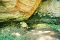
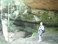 view gallery view gallerySE17.4 km | Princess Arch Rockshelter - Red River Gorge Geological Area, KY US in Cave Entrances (Natural) Take trail head to the right of the Princess Arch TH at N37 49.512 W083 37.057. Follow this trail for about 400 feet and the dog leg to the left down the natural draw at N37 49.537 W083 37.014. This will take you to the rockshelter. posted by: Crazy4horses location: Kentucky date approved: 01/05/2017 last visited: 01/06/2017 |
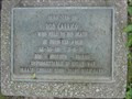 view gallery view galleryS17.5 km |  Rob Carrico Monument at Red River Gorge Rob Carrico Monument at Red River Gorge
in Citizen Memorials Rob Carrico fell from Princess Arch in Kentucky's Red River Gorge on March 4, 1990. At the beginning of the trail to that arch, this is not only a monument to him, but also a reminder to be careful. posted by: Simplenfun location: Kentucky date approved: 08/07/2011 last visited: 10/11/2016 |
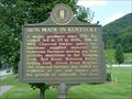 view gallery view galleryNE17.7 km |  Iron Made in Kentucky Iron Made in Kentucky
in Kentucky Historical Markers One side of this marker provides a brief history of iron making in Kentucky. The other side provides a history of nearby Clear Creek Furnace which is also a waymark. posted by: Simplenfun location: Kentucky date approved: 08/11/2011 last visited: 10/11/2016 |
 view gallery view galleryS17.7 km |  Chimney Top Rock - Red River Gorge Geological Area, KY, US Chimney Top Rock - Red River Gorge Geological Area, KY, US
in Places of Geologic Significance Located in Red River gorge geological area on Chimney Top Trail #235 posted by: Crazy4horses location: Kentucky date approved: 01/04/2017 last visited: 01/04/2017 |
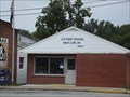 view gallery view galleryNE17.9 km |  Salt Lick, Kentucky, 40371 Salt Lick, Kentucky, 40371
in U.S. Post Offices Salt Lick is a city in Bath County, Kentucky, United States. The population was 342 at the 2000 census. posted by: Simplenfun location: Kentucky date approved: 08/21/2011 last visited: 10/11/2016 |
|