 view gallery view gallery NE11.1 km NE11.1 km
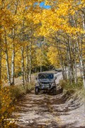
|   Medano Pass - Rio Grande National Forest - Colorado Medano Pass - Rio Grande National Forest - Colorado
in Offroad Trails Medano Pass is a great alternate route into or out of The Great Sand Dunes National Park posted by:  mr.volkswagen mr.volkswagen location: Colorado date approved: 08/24/2017 last visited: 08/22/2017 |
 view gallery view gallery W19.8 km W19.8 km
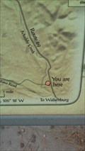
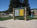
|  YOU ARE HERE! - Huerfano County, CO YOU ARE HERE! - Huerfano County, CO
in 'You Are Here' Maps On a history panel about LT. Zebulon Pike. posted by: mr.volkswagen location: Colorado date approved: 10/04/2016 last visited: never |
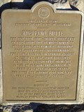
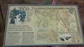 view gallery view galleryW19.8 km |  Lt. Zebulon Pike’s Southwestern Expedition - Huerfano County, CO Lt. Zebulon Pike’s Southwestern Expedition - Huerfano County, CO
in Colorado Historical Markers This historic marker is part of a series of markers that is commemorating Lt. Zebulon Pike’s southwestern expedition. posted by: mr.volkswagen location: Colorado date approved: 09/09/2015 last visited: never |
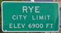 view gallery view galleryNE20.1 km |  Rye, Colorado ~ Elevation 6900 Feet Rye, Colorado ~ Elevation 6900 Feet
in Elevation Signs This Elevation Sign is located on the west side of Boulder Avenue the northern city limits of Rye, Colorado. posted by: brwhiz location: Colorado date approved: 04/02/2013 last visited: never |
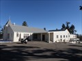
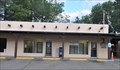
 view gallery view galleryNE20.3 km |  Rye, Colorado 81069 Rye, Colorado 81069
in U.S. Post Offices This Post Office is located at 8084 State Highway 165 in Rye, Colorado. posted by: brwhiz location: Colorado date approved: 10/25/2011 last visited: never |
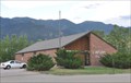
 view gallery view galleryNE20.6 km |  St. Aloysius - Rye, CO St. Aloysius - Rye, CO
in Roman Catholic Churches A small church in Rye Colorado posted by:  Gershon_ben_Franja Gershon_ben_Franja location: Colorado date approved: 02/25/2010 last visited: never |
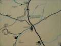
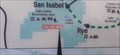 view gallery view gallery N21.6 km N21.6 km
| YOU ARE HERE! - Lake Isabel Recreation Area - San Isabel, CO in 'You Are Here' Maps Located at the North Shore Parking area of Lake Isabel. posted by: mr.volkswagen location: Colorado date approved: 10/19/2021 last visited: never |
 view gallery view galleryN21.7 km |  The Lodge Restaurant - San Isabel, CO The Lodge Restaurant - San Isabel, CO
in Neon Signs Located next to the Lodge. posted by: mr.volkswagen location: Colorado date approved: 03/17/2020 last visited: never |
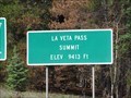 view gallery view gallery SW21.9 km SW21.9 km
| La Veta Pass (new) - Costilla/Huerfano Cty, Co, USA in Elevation Signs This sign is found atop the new La Veta Pass in Colorado, USA. posted by: Outspoken1 location: Colorado date approved: 08/25/2018 last visited: never |
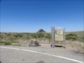
 view gallery view gallery E23 km E23 km
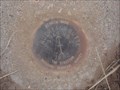
|  Huerfano Butte - Walsenburg, CO Huerfano Butte - Walsenburg, CO
in Azimuth Benchmarks Marker: Dz = Azimuth Mark Disk
Setting: 7 = Set In Top Of Concrete Monument
Stamping: Huerfano Butte No 2 1949 1982
Magnetic: N = No Magnetic Material
Stability: C = May Hold, But Of Type Commonly Subject To Surface Motion posted by: beagle39z location: Colorado date approved: 06/21/2009 last visited: 07/31/2018 |
 view gallery view galleryN23.2 km | Teller County and Pikes Peak, Woodland Park, CO in Colorado Historical Markers This sign, in Woodland Park, Colorado, provides the history of Pikes Peak and a map of Teller County. posted by: Queens Blessing location: Colorado date approved: 06/20/2010 last visited: 09/15/2012 |
 view gallery view galleryE23.2 km | Huerfano Butte in Colorado Historical Markers Located on Interstate 25 North Bound. posted by: mr.volkswagen location: Colorado date approved: 11/30/2007 last visited: 03/19/2022 |
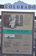 view gallery view galleryE23.2 km | Huerfano Butte - Beacon to Settlement - Huerfano County, Colorado in Colorado Historical Markers This Colorado Historical Marker is located in a turnout on the east side of Interstate Highway 25/US Highway 87 at milepost 59 north of Walsenburg, Colorado. posted by: brwhiz location: Colorado date approved: 03/09/2013 last visited: 07/30/2020 |
 view gallery view galleryE23.2 km | You are on Huerfano Butte, Colorado in 'You Are Here' Maps Huerfano Butte can be seen from miles away. You will need to watch for this sign or you will miss it! posted by: Queens Blessing location: Colorado date approved: 06/13/2010 last visited: 07/30/2020 |
 view gallery view galleryE23.2 km | Huerfano Butte, Beacon to Settlement - Huerfano Cty, CO in Colorado Historical Markers This marker is only accessible from the northbound side of I-25 (unless you drive past and make a loop back). Ample parking. posted by: Outspoken1 location: Colorado date approved: 08/04/2018 last visited: 07/30/2020 |
 view gallery view gallery SE23.2 km SE23.2 km
|  The REAL Calumet, Colorado (Red Dawn) The REAL Calumet, Colorado (Red Dawn)
in Mines The REAL Calumet, Colorado. Not what was depicted in Red Dawn (1984). posted by: DoubleH location: Colorado date approved: 05/23/2012 last visited: never |
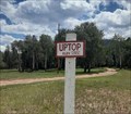 view gallery view gallerySW24.5 km |  Uptop, CO Uptop, CO
in Ghost Towns Uptop, Colorado, was once a thriving railroad town; now abandoned, it is visited only by preservationists and tourists. posted by: The Snowdog location: Colorado date approved: 11/11/2020 last visited: 10/04/2021 |
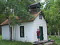 view gallery view gallerySW24.5 km |  Uptop Waychapel Uptop Waychapel
in Waychapels Located on the old La Veta Pass posted by: mr.volkswagen location: Colorado date approved: 07/20/2008 last visited: 07/30/2020 |
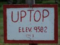 view gallery view gallerySW24.5 km | Uptop, CO (9,382 ft) in Elevation Signs Located on old La Veta Pass posted by: mr.volkswagen location: Colorado date approved: 07/20/2008 last visited: 07/30/2020 |
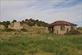
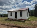 view gallery view gallerySW24.5 km |  Denver and Rio Grand Depot - Uptop, Colorado Denver and Rio Grand Depot - Uptop, Colorado
in Train Stations/Depots At one time the highest railroad tracks in the world were here - in Uptop, Colorado. posted by: The Snowdog location: Colorado date approved: 11/10/2020 last visited: 10/04/2021 |
 view gallery view galleryNE26.7 km | Chief Cuerno Verde - Colorado City, CO in Colorado Historical Markers This historical event, that happened over 200 years ago, is about where Juan Bautista de Anza, then Governor of New Mexico, marched, camped and fought the feared Comanche Chief Cuerno Verde (Greenhorn) on September 3, 1779, just eighteen miles south of Pueblo, Colorado. Cuerno Verde and several of his warriors were killed, an event which literally changed the course of history in what is now Colorado. posted by: beagle39z location: Colorado date approved: 06/03/2009 last visited: never |
 view gallery view galleryNE28 km | Colorado City, Colorado 81019 in U.S. Post Offices This Post Office is located at 4490 Bent Brothers Blvd in Colorado City, Colorado. posted by: brwhiz location: Colorado date approved: 10/25/2011 last visited: never |
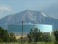 view gallery view galleryNE28.3 km |  WALSENBURG - Water Tank WALSENBURG - Water Tank
in Water Towers WALSENBURG,Colorado Filter Plant Tank posted by: GEO*Trailblazer 1 location: Colorado date approved: 01/23/2007 last visited: 01/23/2007 |
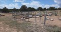 view gallery view gallerySE28.6 km |  Ojito (North Veta) Cemetery - Huerfano County, Colorado Ojito (North Veta) Cemetery - Huerfano County, Colorado
in Worldwide Cemeteries Ojito Cemetery is on the north side of Highway 180, in Huerfano County, Colorado. posted by: The Snowdog location: Colorado date approved: 11/11/2020 last visited: never |
 view gallery view gallerySE28.8 km |  Navajo Ranch, Cemetary Dreaming? Navajo Ranch, Cemetary Dreaming?
in Unintentionally Funny Signs The sign advertises the real estate location of your dreams - next to a cemetary posted by: ronjean location: Colorado date approved: 08/19/2009 last visited: never |
|