 view gallery view gallery W2.3 km W2.3 km
|   Rico, Colorado - Rico, CO Rico, Colorado - Rico, CO
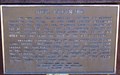
in Colorado Historical Markers The Rico, Colorado historical marker is a bronze plaque mounted on a mine car. posted by:  hummerstation hummerstation location: Colorado date approved: 07/05/2015 last visited: never |
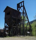 view gallery view galleryW2.3 km |  The Atlantic Cable Mine - Rico, CO The Atlantic Cable Mine - Rico, CO
in Mines The Atlantic Cable Mine headframe and part of the hoist house are located on CO Hwy 145 on the north side of Rico. posted by: hummerstation location: Colorado date approved: 07/07/2015 last visited: never |
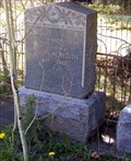
 view gallery view gallery SW3.2 km SW3.2 km
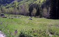
|  Rico Cemetery - Rico, CO Rico Cemetery - Rico, CO
in Worldwide Cemeteries The Rico Cemetery lies between CO Hwy 145 and the Dolores River just south of Rico, CO. posted by: hummerstation location: Colorado date approved: 07/06/2015 last visited: never |
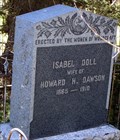 view gallery view gallerySW3.2 km |  Isabel Doll Dawson - Rico Cemetery - Rico, CO Isabel Doll Dawson - Rico Cemetery - Rico, CO
in Woodmen of the World Grave Markers/Monuments The Isabel Doll Women of Woodcraft marker is located in Rico Cemetery. posted by: hummerstation location: Colorado date approved: 07/04/2015 last visited: never |
 view gallery view gallerySW3.2 km | Emily B. Meredith - Rico Cemetery - Rico, CO in Woodmen of the World Grave Markers/Monuments The Emily B. Meredith Neighbors of Woodcraft marker is located in Rico Cemetery. posted by: hummerstation location: Colorado date approved: 07/06/2015 last visited: never |
  SE18.5 km SE18.5 km
|  Durango Mtn resort Colorado Durango Mtn resort Colorado
in Web Cameras Durango co posted by: kingbee location: Colorado date approved: 06/15/2015 last visited: never |
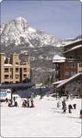 view gallery view gallerySE18.5 km |  Durango Mtn Resort Durango Mtn Resort
in Ski Lodges Durango ski area posted by: kingbee location: Colorado date approved: 09/29/2011 last visited: 09/14/2019 |
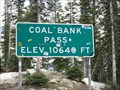 view gallery view gallery E20.1 km E20.1 km
|  Coal Bank Pass - 10,640' Coal Bank Pass - 10,640'
in Elevation Signs Highway 550 between Silverton and Durango, Colorado. posted by: WR7X location: Colorado date approved: 04/28/2012 last visited: 07/19/2015 |
 view gallery view galleryE20.1 km | Coal Bank Pass ~ Elevation 10,660 Feet in Elevation Signs This Elevation Sign is at the summit of Coal Bank Pass on US Highway 550 between Silverton and Durango, Colorado. posted by: brwhiz location: Colorado date approved: 04/27/2013 last visited: never |
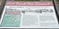
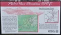
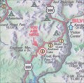 view gallery view galleryE20.1 km |  Coal Bank Pass Summit Coal Bank Pass Summit
in 'You Are Here' Maps You Are Here at the summit of Coal Bank Pass on the San Juan Skyway in southwestern Colorado. posted by: brwhiz location: Colorado date approved: 09/12/2013 last visited: never |
 view gallery view gallery NE21.6 km NE21.6 km
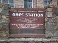
|  Ames Hydroelectric Station Ames Hydroelectric Station
in First of its Kind The Ames Station is the world's first generating station to produce and transmit alternating current. posted by:  krazykatzen krazykatzen location: Colorado date approved: 06/27/2010 last visited: never |
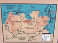 view gallery view galleryNE22.9 km | You Are Here - A Wilderness Legacy - Ophir, CO in 'You Are Here' Maps The "A Wilderness Legacy" panel is located on the west side of Colorado Hwy 145 between Lizard Head Pass and Ophir. posted by: hummerstation location: Colorado date approved: 07/05/2015 last visited: never |
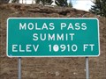 view gallery view galleryE27.5 km | Molas Pass - 10,910' in Elevation Signs Highway 550 between Silverton and Durango, Colorado. posted by: WR7X location: Colorado date approved: 04/28/2012 last visited: 09/12/2019 |
 view gallery view galleryE27.5 km | Molas Pass ~ Elevation 10,899 Feet in Elevation Signs This Elevation Sign is at the summit of Molas Pass on US Highway 550 between Silverton and Durango, Colorado. posted by: brwhiz location: Colorado date approved: 04/27/2013 last visited: 09/12/2019 |
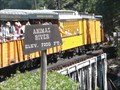 view gallery view gallerySE28.5 km | Animas River - 7200 feet in Elevation Signs This Elevation Sign is on the Durango & Silverton Narrow Guage Railroad where it crosses the Animas River. posted by: PeterNoG location: Colorado date approved: 12/12/2011 last visited: 02/13/2014 |
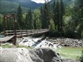 view gallery view galleryE28.5 km |  D&SNGRR / Needleton Footbridge - San Juan Nat'l Forest, Colorado D&SNGRR / Needleton Footbridge - San Juan Nat'l Forest, Colorado
in Hiking Path Footbridges This wooden footbridge crosses the Anamas River at the Needleton Flagstop "Station" of the Durango & Silverton Narrow Guage Railroad. posted by: PeterNoG location: Colorado date approved: 12/12/2011 last visited: 08/27/2008 |
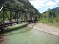 view gallery view galleryE31.2 km |  Durango-Silverton RR Bridge - Animas Valley CO Durango-Silverton RR Bridge - Animas Valley CO
in Railroad Bridges This Railroad Bridge is a half hour from the Silverton Station on the Durango & Silverton Narrow Gauge Railroad. posted by: PeterNoG location: Colorado date approved: 01/03/2014 last visited: 08/27/2008 |
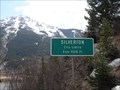 view gallery view galleryE31.4 km | Silverton, Colorado - 9318' in Elevation Signs The sign is located on northbound Highway 550. posted by: WR7X location: Colorado date approved: 04/29/2012 last visited: 06/04/2015 |
 view gallery view galleryNE31.5 km |  Tomboy Mine Office - Telluride Historic District - Telluride, CO Tomboy Mine Office - Telluride Historic District - Telluride, CO
in NRHP Historic Districts - Contributing Buildings The mine office for the famous Tomboy Mine was located in Telluride. posted by: Outspoken1 location: Colorado date approved: 09/13/2015 last visited: never |
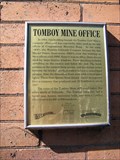 view gallery view galleryNE31.5 km | Tomboy Mine Office - Telluride, CO in Colorado Historical Markers The mine office for the famous Tomboy Mine was located in Telluride. posted by: Outspoken1 location: Colorado date approved: 04/12/2010 last visited: never |
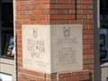 view gallery view galleryNE31.5 km |  1987 - Elks Lodge #692 - Telluride, CO 1987 - Elks Lodge #692 - Telluride, CO
in Dated Buildings and Cornerstones Nicely carved cornerstone of the former Elks Lodge in Telluride, Colorado posted by: Outspoken1 location: Colorado date approved: 02/16/2010 last visited: never |
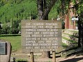 view gallery view galleryNE31.5 km | Telluride History - Telluride, CO in Colorado Historical Markers Plaques in a small park on Telluride's main street posted by: Outspoken1 location: Colorado date approved: 01/23/2011 last visited: 05/12/2023 |
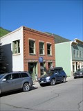
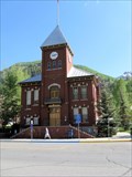
 view gallery view galleryNE31.5 km |  Telluride Historic District - Telluride, CO Telluride Historic District - Telluride, CO
in U.S. National Register of Historic Places Telluride was declared a National Historic Landmark in 1961 and a National Historic District in 1966 posted by: Outspoken1 location: Colorado date approved: 01/23/2011 last visited: 05/12/2023 |
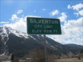 view gallery view galleryNE31.5 km | Silverton, Colorado - 9318' in Elevation Signs This sign is located on southbound Highway 550. posted by: WR7X location: Colorado date approved: 04/29/2012 last visited: 07/14/2015 |
 view gallery view galleryNE31.5 km | San Miguel County Courthouse - Telluride, CO in Colorado Historical Markers San Miguel County Courthouse built in 1887 after the original burned posted by: Outspoken1 location: Colorado date approved: 04/11/2010 last visited: 05/12/2023 |
|