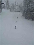
 view gallery view gallery W3.7 km W3.7 km
|   Badger Pass - Yosemite National Park, California Badger Pass - Yosemite National Park, California
in Winter Sports Locations Badger Pass is the oldest ski area in California and offers intermediate to beginner slopes for skiers and snowboarders. posted by:  Touchstone Touchstone location: California date approved: 01/26/2009 last visited: 01/25/2019 |
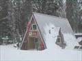
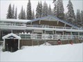 view gallery view galleryW3.7 km |  Badger Pass Ski Lodge - Yosemite National Park, California Badger Pass Ski Lodge - Yosemite National Park, California
in Ski Lodges The Ski Lodge at Badger Pass Ski Area is the first and oldest ski lodge in California. posted by: Touchstone location: California date approved: 01/27/2009 last visited: never |
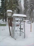
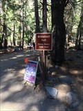
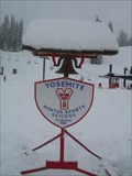 view gallery view galleryW3.7 km |  Yosemite Ski School Bell - Badger Pass Ski Area, California Yosemite Ski School Bell - Badger Pass Ski Area, California
in Bells A seasonal bell which the Yosemite Ski School uses to call students for ski/snowboard lessons. posted by: Touchstone location: California date approved: 01/27/2009 last visited: never |
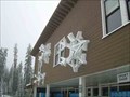 view gallery view galleryW3.7 km |  Badger Pass Snowflakes - Yosemite National Park, California Badger Pass Snowflakes - Yosemite National Park, California
in 3 Dimensional Art These larger than life snowflakes adorn the outside wall of the ski lodge. posted by: Touchstone location: California date approved: 01/26/2009 last visited: never |
 view gallery view galleryW3.9 km |  Badger Pass Weatherstation - Yosemite National Park, California Badger Pass Weatherstation - Yosemite National Park, California
in Weather Stations This weather station sits adjacent to the Badger Pass Ranger Station at the Badger Pass Ski Area in Yosemite National Park, California. posted by: Touchstone location: California date approved: 01/27/2009 last visited: never |
 view gallery view galleryW3.9 km |  Badger Pass Ranger Station - Yosemite National Park, California Badger Pass Ranger Station - Yosemite National Park, California
in Ranger Stations The Badger Pass Ranger Station, or as it is commonly known, the "A Frame", is the place for winter travelers heading out to the backcountry. posted by: Touchstone location: California date approved: 01/26/2009 last visited: never |
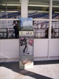 view gallery view gallery SW5.3 km SW5.3 km
|  Yosemite Badger Pass Penny Smasher (Gone) Yosemite Badger Pass Penny Smasher (Gone)
in Penny Smashers This penny smasher is located at Badger Pass Ski Area in Yosemite National Park. The ski area itself is open from about late November to about the end of March. This Penny Smasher has been permanently removed from this location. posted by: Touchstone location: California date approved: 01/17/2007 last visited: 08/12/2012 |
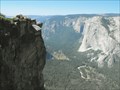 view gallery view gallery N5.8 km N5.8 km
|  Taft Point Scenic Overlook - Yosemite, CA Taft Point Scenic Overlook - Yosemite, CA
in Scenic Overlooks Dramatic overlook with 3000-foot drop to Yosemite Valley below posted by: hotshoe location: California date approved: 09/13/2010 last visited: 07/09/2008 |
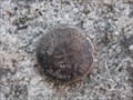
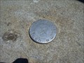 view gallery view galleryN6 km |  Benchmark: Taft Point in Yosemite Benchmark: Taft Point in Yosemite
in U.S. Benchmarks Elevation benchmark at Taft Point in Yosemite National Park. posted by:  kablooey kablooey location: California date approved: 06/18/2008 last visited: 07/14/2021 |
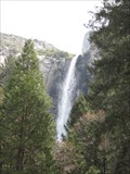 view gallery view galleryN6.6 km |  Bridalveil Fall - Yosemite National Park Bridalveil Fall - Yosemite National Park
in Waterfalls Bridalveil Fall is located at Yosemite National Park. posted by: Mauison location: California date approved: 04/25/2008 last visited: 03/12/2022 |
 view gallery view galleryN6.6 km |  Bridalveil Falls - Yosemite, CA Bridalveil Falls - Yosemite, CA
in Official Local Tourism Attractions Bridalveil Falls is one of the most visited places in the park. posted by: bluesnote location: California date approved: 11/08/2017 last visited: 03/12/2022 |
 view gallery view galleryN6.6 km |  Bridalveil Falls - Yosemite, CA Bridalveil Falls - Yosemite, CA
in Wikipedia Entries Bridalveil Falls is one of the most visited places in the park. posted by: bluesnote location: California date approved: 01/14/2017 last visited: 03/12/2022 |
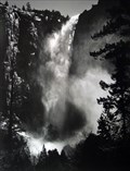 view gallery view galleryN6.6 km |  Bridalveil Falls - Yosemite, CA Bridalveil Falls - Yosemite, CA
in Ansel Adams Photo Hunt Ansel Adams once stood at the base of the falls in 1952 and took some amazing photography of Bridalveil Falls. posted by: bluesnote location: California date approved: 01/13/2017 last visited: 05/07/2023 |
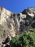
 view gallery view gallery NW6.6 km NW6.6 km
|  Bridalveil Falls Trail - Yosemite, CA Bridalveil Falls Trail - Yosemite, CA
in Hiking and walking trailheads The trailhead for Bridalveil Falls in Yosemite. posted by: bluesnote location: California date approved: 01/14/2017 last visited: 03/12/2022 |
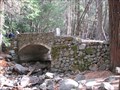 view gallery view galleryN6.8 km |  Yosemite Valley Stone Bridge - Below Bridal Veil Falls Yosemite Valley Stone Bridge - Below Bridal Veil Falls
in Stone Bridges Stone bridge that is now on a pedestrian pathway in Yosemite National Park. posted by: TheBeanTeam location: California date approved: 11/11/2008 last visited: 02/20/2018 |
 view gallery view galleryN6.8 km |  Yosemite National Park - National Parks Edition: Yosemite CA Yosemite National Park - National Parks Edition: Yosemite CA
in Monopoly in the Real World Yosemite National Park is featured in the 1998 USAopoly National Parks Edition. Coordinates are for the center of the Yosemite Valley posted by: TheBeanTeam location: California date approved: 11/13/2008 last visited: 08/01/2023 |
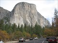
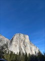
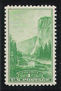 view gallery view galleryN6.9 km |  El Capitan, Yosemite National Park El Capitan, Yosemite National Park
in Philatelic Photographs Rising over 3000 feet above the valley floor, the rock formation known as El Capitan represents Yosemite on the 1934 National Parks set of U.S. postage stamps. posted by: hykesj location: California date approved: 06/14/2013 last visited: 07/31/2017 |
 view gallery view galleryN6.9 km |  Merced River Flood 1/2/1997 - (El Capitan) Yosemite, CA Merced River Flood 1/2/1997 - (El Capitan) Yosemite, CA
in High Level Marks Bronze mark in boulder near roadway marks the damaging flood level. posted by: sparkey916 location: California date approved: 08/31/2011 last visited: 02/20/2018 |
 view gallery view galleryN7.1 km |  Mother of famed climber summits El Capitan to celebrate turning 70 Mother of famed climber summits El Capitan to celebrate turning 70
in News Article Locations A story about the ascent of El Capitan. posted by: saopaulo1 location: California date approved: 03/02/2022 last visited: never |
 view gallery view galleryNW7.1 km | Valley View, Yosemite National Park in Philatelic Photographs This classic scene of Yosemite Valley looking east from the valley floor shows El Capitan on the left and Bridal Veil Falls on the right. posted by: hykesj location: California date approved: 06/14/2013 last visited: 09/24/2016 |
 view gallery view galleryW7.2 km |  Glacier Point Rest Area - Yosemite, CA Glacier Point Rest Area - Yosemite, CA
in Highway Rest Areas A small rest area inside Yosemite National Park. posted by: bluesnote location: California date approved: 11/25/2016 last visited: 11/25/2016 |
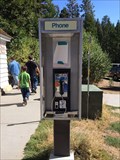 view gallery view galleryW7.2 km |  Glacier Point Rest Area - Yosemite, CA Glacier Point Rest Area - Yosemite, CA
in Payphones A payphone at the Glacier Point rest area within Yosemite National Park. posted by: bluesnote location: California date approved: 10/22/2016 last visited: 10/22/2016 |
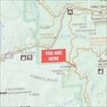 view gallery view galleryW7.2 km |  Glacier Point Rest Area Map - Yosemite, CA Glacier Point Rest Area Map - Yosemite, CA
in 'You Are Here' Maps A map located at a rest stop inside Yosemite National Park. posted by: bluesnote location: California date approved: 11/20/2016 last visited: 11/20/2016 |
 view gallery view gallery NE7.6 km NE7.6 km
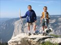
|  Sentinel Dome, Yosemite Sentinel Dome, Yosemite
in Mountain Summits Views of Yosemite that rival the views from Half Dome ... without the 16 mile, 4700 foot elevation gain hike. posted by: Sgt Stitches location: California date approved: 09/07/2005 last visited: 08/01/2023 |
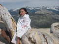 view gallery view galleryNE7.6 km | Scenic Overlook: Sentinel Dome in Scenic Overlooks At the top of Sentinel Dome, you get 360 degrees views of Yosemite Valley posted by: 50sumtin location: California date approved: 08/18/2006 last visited: 08/01/2023 |
|