 view gallery view gallery S2.9 km S2.9 km
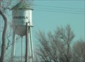
|   HH0906: Minneola Mun Water Tank - Minneola KS HH0906: Minneola Mun Water Tank - Minneola KS
in U.S. Benchmarks This Benchmark is just north of US Hwy 54 and 300 yards east of US Hwy 283 in Minneola, Kansas posted by:  PeterNoG PeterNoG location: Kansas date approved: 09/08/2013 last visited: 12/27/2010 |
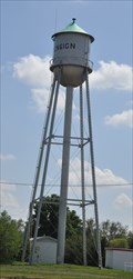
 view gallery view galleryS2.9 km |  Water Tower - Minneola KS Water Tower - Minneola KS
in Water Towers This water tower is just north of Hwy 54 and 300 yards east of Hwy 283 in Minneola, Kansas posted by: PeterNoG location: Kansas date approved: 02/14/2011 last visited: 12/27/2010 |
 view gallery view gallery E10.3 km E10.3 km
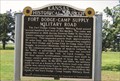
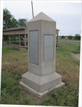
|  Fort Dodge-Camp Supply Military Road - near Bloom, KS Fort Dodge-Camp Supply Military Road - near Bloom, KS
in Wagon Roads and Trails The road passed west of this marker and ended at this marker: WMNAJ6 posted by: YoSam. location: Kansas date approved: 03/09/2015 last visited: 01/07/2016 |
 view gallery view galleryE10.3 km |  Fort Dodge-Camp Supply Military Road - US 54 Fort Dodge-Camp Supply Military Road - US 54
in Kansas Historical Markers This Kansas historical marker is on US 54 northeast of Bloom posted by: PeterNoG location: Kansas date approved: 01/06/2008 last visited: 10/27/2021 |
 view gallery view gallery W23.8 km W23.8 km
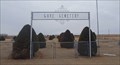
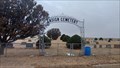
|  Cave Cemetery - Gray County, KS Cave Cemetery - Gray County, KS
in Worldwide Cemeteries This rural cemetery is about six miles south of Ensign, Kansas. posted by: The Snowdog location: Kansas date approved: 11/20/2022 last visited: never |
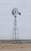 view gallery view galleryS25.3 km |  Little Basin Windmill - Clark County, KS Little Basin Windmill - Clark County, KS
in Windmills This lonely windmill, atop a ridge between Big Basin and Little Basin, is still pumping water - in Clark County, Kansas. posted by: The Snowdog location: Kansas date approved: 11/22/2022 last visited: never |
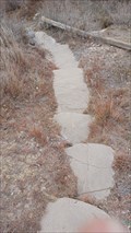 view gallery view galleryS25.4 km |  St. Jacob's Well Stairs - Clark County, KS St. Jacob's Well Stairs - Clark County, KS
in Outdoor Stairways These stone steps lead from the parking area down to St. Jacob's Well - in Clark County, Kansas. posted by: The Snowdog location: Kansas date approved: 11/27/2022 last visited: never |
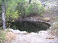 view gallery view galleryS25.4 km |  St Jacob's Well St Jacob's Well
in Natural Sinkholes A fenced pool of water never known to have gone dry contained in Little Basin and accessable by a rough gravel track and trail east of US 283, south of Dodge City. posted by:  boisfort boisfort location: Kansas date approved: 04/29/2007 last visited: 11/19/2022 |
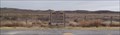 view gallery view galleryS25.4 km | Big Basin - Clark County, KS in Natural Sinkholes These coordinates bring you to a Kansas Historical Marker on the east side of Highway 283, near the center of Big Basin - in Clark County, Kansas. posted by: The Snowdog location: Kansas date approved: 12/03/2022 last visited: never |
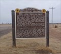 view gallery view galleryS25.4 km | Big Basin - Clark County, KS in Kansas Historical Markers This Kansas Historical Marker is at a large pull-out on the east side of Highway 283, in the middle of Big Basin - in Clark County, Kansas. posted by: The Snowdog location: Kansas date approved: 11/21/2022 last visited: never |
 view gallery view gallery NW27.2 km NW27.2 km
| Ensign Cemetery - Ensign, KS in Worldwide Cemeteries This small rural cemetery is about a mile south of Ensign, Kansas. posted by: The Snowdog location: Kansas date approved: 11/20/2022 last visited: never |
 view gallery view gallery NE28.8 km NE28.8 km
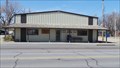
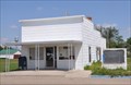
|  Ford, Kansas US Post Office 67842 Ford, Kansas US Post Office 67842
in U.S. Post Offices This postoffice services Ford and the surrounding area. posted by: team coldwine location: Kansas date approved: 03/22/2014 last visited: 01/07/2016 |
 view gallery view galleryNW29 km | Ensign, Kansas Water Tower in Water Towers This traditional cylindrical water tower is located on the south side of US Highway 56 (Bent Street) on the east side of Lamed Street in Ensign, Kansas. posted by: brwhiz location: Kansas date approved: 10/04/2012 last visited: 11/21/2022 |
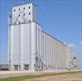 view gallery view galleryNW29 km |  Dodge City Coop Exchange Elevator Dodge City Coop Exchange Elevator
in Grain Elevators This Grain Elevator is located on the north side of Bent Street (US Highway 56) just east of Leavenworth Street in Ensign, Kansas. posted by: brwhiz location: Kansas date approved: 02/08/2013 last visited: never |
 view gallery view galleryNW29 km | USCGS HH0880 ~ ENSIGN MUN WATER TANK in U.S. Benchmarks This surveyor's mark is the finial at the peak of the older-style water tower located on the south side of US Highway 56 (Bent Street) on the east side of Lamed Street in Ensign, Kansas. posted by: brwhiz location: Kansas date approved: 10/05/2012 last visited: 11/21/2022 |
 view gallery view galleryNW29 km | Ensign, Kansas 67841 in U.S. Post Offices This Post Office is located at 306 Aubrey Street in Ensign, Kansas. posted by: brwhiz location: Kansas date approved: 09/01/2012 last visited: never |
 view gallery view gallery N29.5 km N29.5 km
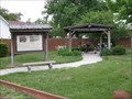
|  Coronado Historical Park - Ford County, Kansas Coronado Historical Park - Ford County, Kansas
in Spirit of '76 The Coronado Historical Park was designated an Officel Bicentennial Project by the National Bicentennial Committee. posted by: Queens Blessing location: Kansas date approved: 06/06/2010 last visited: 09/15/2012 |
 view gallery view galleryN29.5 km |  South Drive-In Theater - Dodge City, KS South Drive-In Theater - Dodge City, KS
in Official Local Tourism Attractions The South Drive-In Theater has been designated as an Official Local Tourist Attraction by the State of Kansas - in Dodge City, Kansas. posted by: The Snowdog location: Kansas date approved: 11/20/2022 last visited: never |
 view gallery view galleryN29.5 km |  South Drive-In Theater - Dodge City, KS South Drive-In Theater - Dodge City, KS
in Drive-In Movie Theaters The South Drive-In Theater lets you re-live your youthful days, or introduce your children to the fun of a drive-in movie - in Dodge City, Kansas. posted by: The Snowdog location: Kansas date approved: 11/21/2022 last visited: never |
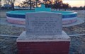
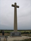 view gallery view galleryN29.6 km |  FIRST Christian Service west of Mississippi River, Fort Dodge, KS FIRST Christian Service west of Mississippi River, Fort Dodge, KS
in First of its Kind The plaque at this location indicates the FIRST Christian service west of the Mississippi River occurred here in 1541. posted by: Queens Blessing location: Kansas date approved: 06/13/2010 last visited: 09/15/2012 |
 view gallery view galleryN29.9 km |  Fort Dodge Post Cemetery - Fort Dodge, KS Fort Dodge Post Cemetery - Fort Dodge, KS
in Veteran Cemeteries Kansas Veterans Cemetery at Fort Dodge is on the south side of US 400 - in Dodge City, Kansas. posted by: The Snowdog location: Kansas date approved: 12/27/2022 last visited: never |
 view gallery view galleryN29.9 km | Sante Fe Trail, Fort Dodge, Kansas in Wagon Roads and Trails The Santa Fe Trail was used between Following the Santa Fe Trail: A Guide for Modern Travelers, by Marc Simmons (new, used)
* Maps of the Santa Fe posted by: Queens Blessing location: Kansas date approved: 06/07/2010 last visited: 09/15/2012 |
 view gallery view galleryN29.9 km | James S. Wagnor - Dodge City, KS in Specific Veteran Memorials This memorial to James S. Wagnor is at historic Fort Dodge - in Dodge City, Kansas. posted by: The Snowdog location: Kansas date approved: 12/28/2022 last visited: never |
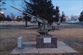 view gallery view galleryN29.9 km |  Anti-Aircraft Gun - Dodge City, KS Anti-Aircraft Gun - Dodge City, KS
in Static Artillery Displays This anti-aircraft gun is on display at historic Fort Dodge - in Dodge City, Kansas. posted by: The Snowdog location: Kansas date approved: 12/28/2022 last visited: 11/30/2023 |
 view gallery view galleryN29.9 km | Fort Dodge, Ford County, Kansas in Kansas Historical Markers This is Kansas Historical Marker sign #75. posted by: Queens Blessing location: Kansas date approved: 08/09/2010 last visited: 12/28/2022 |
|