 view gallery view gallery S5 km S5 km
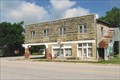
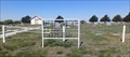
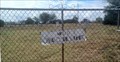
|   Cowley County Fire Dist. No. 3 Cowley County Fire Dist. No. 3
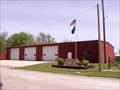
in Firehouses Burden Fire Department is located at the corner of 5th Street and Chestnut Street in Burden. The current location at 508 Chestnut has been occupied since it was built in 1980. posted by:  SafireLady SafireLady location: Kansas date approved: 05/06/2008 last visited: 01/23/2010 |
 view gallery view galleryS5.1 km |  Burden, Kansas 67019 Burden, Kansas 67019
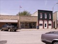
in U.S. Post Offices This Post Office is in the 400 block of South Main Street in Burden Kansas. There is little left on main Street there that is open in this fading small town. I like the way they used red, white and blue paint on the words on their building. posted by: SafireLady location: Kansas date approved: 05/06/2008 last visited: 01/23/2010 |
 view gallery view gallery SW5.3 km SW5.3 km
|  Welcome to Burden Welcome to Burden
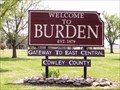
in Welcome Signs Welcome to Burden, Kansas. posted by: SafireLady location: Kansas date approved: 05/07/2008 last visited: 01/23/2010 |
 view gallery view gallery SE7.7 km SE7.7 km
| Cambridge, Kansas 67023 in U.S. Post Offices Red Brick Cambridge Post Office established January 30, 1880. posted by: SafireLady location: Kansas date approved: 04/06/2008 last visited: 01/23/2010 |
 view gallery view gallerySE7.7 km |  Stockman's Cafe - Cambridge, KS Stockman's Cafe - Cambridge, KS
in Independent Breakfast Spots Stopped for a quick breakfast in 2010...all men at 7am posted by:  YoSam. YoSam. location: Kansas date approved: 03/17/2015 last visited: never |
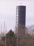 view gallery view gallerySE7.7 km |  Cambridge Water Tower - Cambridge, Kansas Cambridge Water Tower - Cambridge, Kansas
in Water Towers The coordinates are not exact, but the tower is seen best from them. The tower looks like a huge blue silo. posted by: SafireLady location: Kansas date approved: 04/06/2008 last visited: 01/23/2010 |
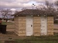 view gallery view gallerySE7.7 km |  His and Hers in Cambridge Kansas His and Hers in Cambridge Kansas
in Outhouses Stone outhouse located behind the Stockman Cafe in Cambridge, Kansas. posted by: SafireLady location: Kansas date approved: 04/09/2008 last visited: 03/15/2015 |
 view gallery view gallerySE7.7 km |  The Count - Cambridge, Kansas The Count - Cambridge, Kansas
in Murals This is a nice little Mural on the East side of the Stockmans Cafe, easily seen from US-160 if you are driving Westward through Cambridge, and you don't blink. posted by: SafireLady location: Kansas date approved: 04/09/2008 last visited: 03/15/2015 |
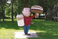 view gallery view gallerySE7.7 km |  A&W Guy (formerly called Big Boy) - Cambridge, KS (missing) A&W Guy (formerly called Big Boy) - Cambridge, KS (missing)
in Giants of Commerce Elias Big Boy ...here? May not be Big Boy..any one know this one?
Up Date: According to information provided by The Bean Team, this is an A&W burger guy. posted by: YoSam. location: Kansas date approved: 03/15/2015 last visited: never |
 view gallery view gallery W13 km W13 km
|  Wilmot Cemetery - Wilmot, KS Wilmot Cemetery - Wilmot, KS
in Worldwide Cemeteries Wilmot Cemetery is in the small town of Wilmot, Kansas. posted by: The Snowdog location: Kansas date approved: 05/11/2023 last visited: never |
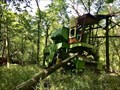 view gallery view gallerySW18 km |  John Deere 95 - Cowley County, Kansas John Deere 95 - Cowley County, Kansas
in Abandoned Dead Vehicles This abandoned John Deere 95 combine sits just off to the north side 182nd Road, roughly 2 miles to the southwest of the community of Tisdale. posted by: Tom.dog location: Kansas date approved: 07/30/2023 last visited: never |
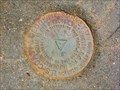
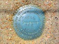 view gallery view galleryW18 km |  WHEEL AZI - Cowley County, Kansas WHEEL AZI - Cowley County, Kansas
in Azimuth Benchmarks The azimuth mark for triangulation station WHEEL. posted by: Tom.dog location: Kansas date approved: 07/05/2023 last visited: never |
 view gallery view galleryW18 km |  WHEEL AZI - Cowley County, Kansas WHEEL AZI - Cowley County, Kansas
in U.S. Benchmarks The azimuth mark for triangulation station WHEEL. posted by: Tom.dog location: Kansas date approved: 11/17/2022 last visited: never |
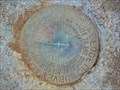
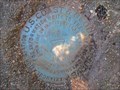 view gallery view galleryW18.7 km | WHEEL (HF1162) - Cowley County, Kansas in U.S. Benchmarks A triangulation station set to the west of 121st Rd. posted by: Tom.dog location: Kansas date approved: 11/17/2022 last visited: never |
 view gallery view gallery NW20.1 km NW20.1 km
| Muqbra Muslim Cemetery - Butler County, KS in Worldwide Cemeteries This small cemetery is near the old Rock Creek Township - in Butler County, Kansas. posted by: The Snowdog location: Kansas date approved: 09/17/2023 last visited: never |
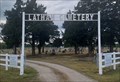 view gallery view gallery N20.6 km N20.6 km
| Latham Cemetery - Latham, KS in Worldwide Cemeteries Latham Cemetery is on the west edge of Latham, Kansas. posted by: The Snowdog location: Kansas date approved: 09/17/2023 last visited: never |
 view gallery view galleryS20.8 km | Dexter Cemetery - Dexter, KS in Worldwide Cemeteries This cemetery, on the southeast side of Dexter, Kansas, inters about two thousand souls. posted by: The Snowdog location: Kansas date approved: 12/15/2019 last visited: never |
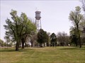 view gallery view galleryNW21.7 km | Burden Kansas Water Tower in Water Towers From a distance the top of this water tower looks like the Tin Mans hat. posted by: SafireLady location: Kansas date approved: 05/08/2008 last visited: 01/23/2010 |
 view gallery view galleryN21.9 km | Bryant Cemetery - Latham, KS in Worldwide Cemeteries Latham Cemetery is on the west side of an unimproved country road - about five miles northwest of Latham, Kansas. posted by: The Snowdog location: Kansas date approved: 09/17/2023 last visited: never |
 view gallery view galleryW24 km | MILNUT RM 1 (HF0689) - Cowley County, Kansas in U.S. Benchmarks Reference mark 1 for triangulation station MILNUT. posted by: Tom.dog location: Kansas date approved: 11/17/2022 last visited: never |
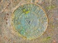
 view gallery view galleryW24 km | MILNUT (HF0688) - Cowley County, Kansas in U.S. Benchmarks A triangulation station at a decommissioned missile site south of Rock, Kansas. posted by: Tom.dog location: Kansas date approved: 11/17/2022 last visited: never |
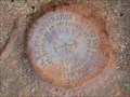 view gallery view galleryW24 km | MILNUT RM 2 (HF0687) - Cowley County, Kansas in U.S. Benchmarks Reference mark 2 for triangulation station MILNUT. posted by: Tom.dog location: Kansas date approved: 11/17/2022 last visited: never |
 view gallery view galleryW24 km | AKRON (HF1285) - Cowley County, Kansas in U.S. Benchmarks A triangulation station located on the east side of US 77 about 5 miles south of Rock, Kansas. posted by: Tom.dog location: Kansas date approved: 11/17/2022 last visited: never |
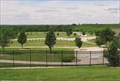
 view gallery view gallerySW24 km |  Kansas Veterans Cemetery - Winfield, KS Kansas Veterans Cemetery - Winfield, KS
in Veteran Cemeteries The Kansas Veterans’ Cemetery at Winfield is open to visitors every day of the year from sunrise to sunset. The cemetery floral regulations are posted outside the administration building. posted by: YoSam. location: Kansas date approved: 03/19/2015 last visited: never |
 view gallery view gallerySW24.1 km | Kansas Veterans Cemetery - Winfield, KS in Worldwide Cemeteries The Kansas Veterans’ Cemetery at Winfield is open to visitors every day of the year from sunrise to sunset. The cemetery floral regulations are posted outside the administration building. posted by: YoSam. location: Kansas date approved: 03/23/2015 last visited: never |
|