 view gallery view gallery E8.7 km E8.7 km
|   Montgomery Drive-In - Chaffee MO Montgomery Drive-In - Chaffee MO
in Closed Drive-In Theatres Montgomery Drive-In- Chaffee MO posted by:  kJfishman kJfishman location: Missouri date approved: 05/29/2013 last visited: 05/25/2013 |
 view gallery view gallery N13.5 km N13.5 km
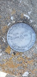
|  17 FDR 1966 - Byrd Township, MO 17 FDR 1966 - Byrd Township, MO
in U.S. Benchmarks Geological Survey mark at the Immanuel Lutheran Church in Byrd Township posted by: HiddenCrazy location: Missouri date approved: 04/28/2021 last visited: 02/24/2021 |
 view gallery view gallery W15.4 km W15.4 km
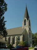
|  St. John's Church and Shrine - Leopold, MO St. John's Church and Shrine - Leopold, MO
in Roman Catholic Churches Built in 1901, St. John's is a fine example of German architecture with stained glass windows and arches. It has one of the oldest pipe organs west of the Mississippi River. posted by: paulspaper location: Missouri date approved: 10/13/2007 last visited: never |
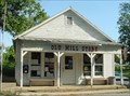
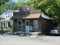 view gallery view galleryW15.6 km |  Leopold, Missouri, 63760 Leopold, Missouri, 63760
in U.S. Post Offices Post office in the rural community of Leopold, Missouri. posted by: paulspaper location: Missouri date approved: 10/13/2007 last visited: never |
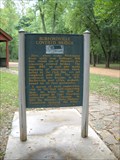 view gallery view galleryN16.7 km |  Burfordville Covered Bridge/Bollinger Mill - Burfordville, Mo. Burfordville Covered Bridge/Bollinger Mill - Burfordville, Mo.
in Missouri Historical Markers This Historical Marker is located within the Bollinger Mill State Park - 113 Bollinger Mill Road in Burfordville. Mo. posted by: iconions location: Missouri date approved: 10/05/2011 last visited: never |
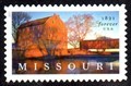 view gallery view galleryN16.7 km |  Bollinger Mill and Covered Bridge, Burfordville, MO Bollinger Mill and Covered Bridge, Burfordville, MO
in Philatelic Photographs A view of Bollinger Mill State Historic Site graces this 2021 postage stamp commemorating the State of Missouri’s 200th anniversary. posted by: hykesj location: Missouri date approved: 08/29/2021 last visited: never |
 view gallery view gallery NW16.7 km NW16.7 km
| Gravel Hill United Methodist Church - MO in Country Churches Rural church in Southeast Missouri. posted by: paulspaper location: Missouri date approved: 10/13/2007 last visited: never |
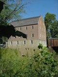
 view gallery view galleryN16.7 km |  Bollinger Mill State Historic Site - Bollinger MO Bollinger Mill State Historic Site - Bollinger MO
in Civil War Discovery Trail Sites The Mill was burnt down by the Union Army to prevent flour and meal to be sent to the Confederate Army. posted by: kJfishman location: Missouri date approved: 04/09/2016 last visited: 09/24/2011 |
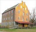
 view gallery view galleryN16.7 km |  Bollinger Mill, Burfordville, Missouri Bollinger Mill, Burfordville, Missouri
in Water Mills Bollinger Mill is a massive four-story stone and brick building where visitors can still observe corn being ground into meal by water power - just as it was done long ago. posted by: paulspaper location: Missouri date approved: 10/14/2007 last visited: 09/27/2011 |
 view gallery view galleryN16.7 km |  Cape County Milling Company - Bollinger Mill Burfordville, Missouri Cape County Milling Company - Bollinger Mill Burfordville, Missouri
in Ghost Signs Cape County Milling Company - Bollinger Mill Burfordville, Missouri posted by: kJfishman location: Missouri date approved: 12/18/2009 last visited: 09/24/2011 |
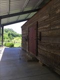
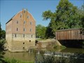 view gallery view galleryN16.7 km |  Burfordville Mill Burfordville Mill
in U.S. National Register of Historic Places Burfordville Mill, known as Bollinger Mill, is a massive four-story stone and brick building where visitors can still observe corn being ground into meal by water power - just as it was done long ago.
posted by: paulspaper location: Missouri date approved: 10/13/2007 last visited: 09/24/2011 |
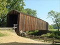 view gallery view galleryN16.7 km |  Burfordville Covered Bridge - Burfordville, Missouri Burfordville Covered Bridge - Burfordville, Missouri
in Covered Bridges Burfordville Covered Bridge is the oldest remaining covered bridge in Missouri. Located in Bollinger Mill State Historic Site. posted by: paulspaper location: Missouri date approved: 10/12/2007 last visited: 09/24/2011 |
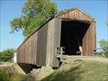 view gallery view galleryN16.7 km | Burfordville Covered Bridge in U.S. National Register of Historic Places Burfordville Covered Bridge is the oldest remaining covered bridge in Missouri. Located in Bollinger Mill State Historic Site. posted by: paulspaper location: Missouri date approved: 10/13/2007 last visited: 09/24/2011 |
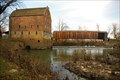 view gallery view galleryN16.7 km |  Bollinger Mill State Historic Site - Bollinger, MO Bollinger Mill State Historic Site - Bollinger, MO
in State/Provincial Parks Historic wood covered bridge and mill at Bollinger Mill State Historic Site. posted by: kJfishman location: Missouri date approved: 04/04/2016 last visited: 09/24/2011 |
 view gallery view galleryN16.7 km | Burfordville, Missouri, 63739 in U.S. Post Offices Post office Burfordville, Missouri. Located at 353 State Highway HH, Burfordville, MO, 63739-9998 posted by: paulspaper location: Missouri date approved: 10/11/2007 last visited: 11/22/2009 |
 view gallery view gallery NE17.1 km NE17.1 km
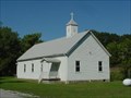
| Old Bethel Baptist Church - Jackson, MO. in This Old Church Built in 1806 as of 2016 this church is 210 years old. And has wooden pegs instead of nails. posted by: Mesozoic location: Missouri date approved: 06/09/2016 last visited: never |
 view gallery view galleryNE17.1 km |  Old Bethel Baptist Church - Jackson, MO Old Bethel Baptist Church - Jackson, MO
in Baptist Churches Built in 1806 as of 2016 this church is 210 years old. And has wooden pegs instead of nails. posted by: Mesozoic location: Missouri date approved: 06/09/2016 last visited: never |
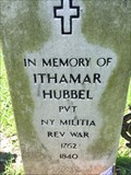 view gallery view galleryNE17.1 km |  PVT. Ithamar Hubbel PVT. Ithamar Hubbel
in American Revolutionary War Veteran Graves Located in the cemetery near the old church building. posted by: Mesozoic location: Missouri date approved: 07/02/2016 last visited: never |
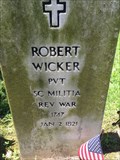 view gallery view galleryNE17.1 km | PVT. Robert Wicker - Jackson, MO. in American Revolutionary War Veteran Graves Located in the cemetery near the old church building. posted by: Mesozoic location: Missouri date approved: 07/02/2016 last visited: never |
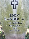 view gallery view galleryNE17.1 km | Enos Randol SR. - Jackson, MO. in American Revolutionary War Veteran Graves Located in the cemetery near the old church building. posted by: Mesozoic location: Missouri date approved: 07/02/2016 last visited: never |
 view gallery view galleryNE17.1 km |  Old Bethal Cemetery - Jackson, MO. Old Bethal Cemetery - Jackson, MO.
in Worldwide Cemeteries A VERY old cemetery with three revolutionary soldiers buried here. posted by: Mesozoic location: Missouri date approved: 06/09/2016 last visited: never |
 view gallery view galleryNE17.1 km |  Unknown - Old Bethal Cemetery - Jackson, MO. Unknown - Old Bethal Cemetery - Jackson, MO.
in Graves of the Unknown There are at least a dozen graves in this Old Bethal Cemetery that are listed as unknown. posted by: Mesozoic location: Missouri date approved: 06/10/2016 last visited: never |
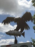 view gallery view galleryNE17.4 km |  Bald Eagle catches a fish - Jackson, MO. Bald Eagle catches a fish - Jackson, MO.
in Figurative Public Sculpture Bald Eagle catching a fish posted by: Mesozoic location: Missouri date approved: 06/11/2016 last visited: never |
 view gallery view galleryNE17.5 km |  Sam's Club #6479 - Cape Girardeau, Missouri Sam's Club #6479 - Cape Girardeau, Missouri
in WAL*MART Stores This Sam's Club can be found in a shopping center at exit 96 off of I-55. The shopping center is west and south of the intersection. posted by:  gparkes gparkes location: Missouri date approved: 04/06/2010 last visited: 09/28/2011 |
 view gallery view galleryNE17.7 km | Walmart Supercenter - Cape Girardeau, Missouri (#188) in WAL*MART Stores Cape Girardeau is the county seat of Cape Girardeau County and the home to South East Missouri University (SEMU). Walmart is located on the west of I-55 at exit 96. posted by: gparkes location: Missouri date approved: 02/15/2010 last visited: 09/28/2011 |
|