 view gallery view gallery SW0.3 km SW0.3 km
|   CO/NM Border on CO 17/NM/17 CO/NM Border on CO 17/NM/17
in Border Crossings As you travel the southern slope of Cumbres Pass you cross the border between Colorado and New Mexico. Only a change in the pavement marks the actual border. posted by:  brwhiz brwhiz location: New Mexico date approved: 11/19/2012 last visited: 05/29/2014 |
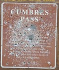 view gallery view gallerySW0.3 km |  Cumbres Pass Cumbres Pass
in New Mexico Historical Markers This badly damaged New Mexico Official Scenic Historic Marker is located at a turnout at the Colorado/New Mexico border. The reverse side shows the location of other similar markers in the general area. posted by: brwhiz location: New Mexico date approved: 11/05/2012 last visited: 05/29/2014 |
 view gallery view gallerySW0.6 km |  Welcome to New Mexico - Land of Enchantment Welcome to New Mexico - Land of Enchantment
in Welcome Signs This Welcome Sign sits (leans) on the east side of New Mexico Highway 17 as you descend the southern slope of Cumbres Pass and shortly after you cross over the border from Colorado. posted by: brwhiz location: New Mexico date approved: 11/18/2012 last visited: 05/29/2014 |
 view gallery view gallerySW0.6 km | Welcome to New Mexico ~ The Land of Enchantment in Welcome Signs This Welcome Sign is on the west side of New Mexico Highway 17 as you descend the southern slope of Cumbres Pass and shortly after you cross over the border from Colorado. posted by: brwhiz location: New Mexico date approved: 02/06/2013 last visited: 05/29/2014 |
 view gallery view gallery NE4.8 km NE4.8 km
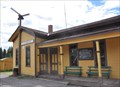
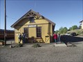
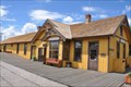
|  Cumbres Station Cumbres Station
in Train Stations/Depots This Train Station is located on the west side of Colorado Highway 17 at the summit of Cumbres Pass about 4 miles northeast of the Colorado/New Mexico border. posted by: brwhiz location: Colorado date approved: 03/11/2013 last visited: 09/24/2015 |
 view gallery view galleryNE4.8 km |  Cumbres Station ~ Elevation 10015 Feet Cumbres Station ~ Elevation 10015 Feet
in Elevation Signs This Elevation Sign is mounted on the end of the Cumbres Train Station at the summit of Cumbres Pass southwest of Antonito, Colorado. posted by: brwhiz location: Colorado date approved: 05/06/2013 last visited: never |
 view gallery view galleryNE5 km |  Cumbres Pass Summit Information Kiosk Cumbres Pass Summit Information Kiosk
in 'You Are Here' Maps You Are Here at the Cumbres Pass Summit Information Kiosk on the west side of Colorado Highway just south of the narrow guage tracks east of the Cumbres pass Train Station of the Cumbres & Toltec Narrow Guage Scenic Railroad. posted by: brwhiz location: Colorado date approved: 08/29/2013 last visited: never |
 view gallery view galleryNE5 km |  Cumbres Station Cumbres Station
in Active Rail Locations Cubres Station, just west of Colorado Highway 17 at the summit of Cumbres Pass, is a great place to witness narrow guage steam power twice a day during the tourist season. posted by: brwhiz location: Colorado date approved: 03/11/2013 last visited: never |
 view gallery view galleryNE5 km | Cumbres Pass ~ Altitude 10,022 Feet in Elevation Signs This Elevation is part of the Historical Marker mounted on a slab of rock on the west side of Colorado Highway 17 at the summit of Cumbres Pass about 4 miles northeast of the Colorado/New Mexico border. posted by: brwhiz location: Colorado date approved: 03/11/2013 last visited: 09/25/2015 |
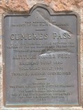
 view gallery view galleryNE5 km |  Cumbres Pass - Conejo County, Colorado Cumbres Pass - Conejo County, Colorado
in Colorado Historical Markers This Colorado Historical Marker is mounted on a slab of rock on the west side of Colorado Highway 17 at the summit of Cumbres Pass about 4 miles north northeast of the Colorado/New Mexico border. posted by: brwhiz location: Colorado date approved: 03/11/2013 last visited: 09/24/2015 |
 view gallery view galleryNE5 km | Cumbres Pass ~ Elevation 10,022 Feet in Elevation Signs This Elevation Sign is at the summit of Cumbres Pass on Colorado Highway 17 between Antonito, Colorado and Chama, New Mexico. posted by: brwhiz location: Utah date approved: 04/26/2013 last visited: 09/25/2015 |
 view gallery view gallerySW11.3 km |  Chama, New Mexico ~ Population 1232 Chama, New Mexico ~ Population 1232
in Population Signs This combination Elevation/Population sign is at the northern village limits of Chama, New Mexico on New Mexico Highway 17. posted by: brwhiz location: New Mexico date approved: 09/12/2012 last visited: never |
 view gallery view gallerySW11.3 km | Chama, New Mexico ~ Elevation 7860 Feet in Elevation Signs This combination Elevation/Population sign is at the northern village limits of Chama, New Mexico on New Mexico Highway 17. posted by: brwhiz location: New Mexico date approved: 09/07/2012 last visited: never |
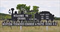
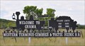
 view gallery view gallerySW11.3 km |  Welcome to Chama, New Mexico Welcome to Chama, New Mexico
in Artistic Welcome Signs This Welcome Sign in the shape of a narrow guage steam locomotive is at the northern village limits of Chama, New Mexico on New Mexico Highway 17. posted by: brwhiz location: New Mexico date approved: 09/07/2012 last visited: never |
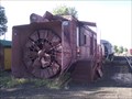 view gallery view gallerySW12.7 km |  Rotary OM Snowplow - Cumbres and Toltec Scenic Railroad - Chama NM Rotary OM Snowplow - Cumbres and Toltec Scenic Railroad - Chama NM
in Railroad Maintenance-Of-Way Equipment This Rotary Snowplow is on display in the yard of the Combres and Toltec scenic railroad. posted by:  GT.US GT.US location: New Mexico date approved: 08/16/2011 last visited: 06/08/2012 |
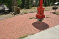 view gallery view gallerySW12.7 km |  Chama Town Clock ~ Chama, New Mexico Chama Town Clock ~ Chama, New Mexico
in Donated Engraved Bricks and Pavers The Donor Bricks testify to contributions toward the purchase and installation of the town clock at Terrace Avenue and 5th Street in downtown Chama, New Mexico. posted by: brwhiz location: New Mexico date approved: 11/06/2012 last visited: never |
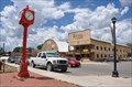 view gallery view gallerySW12.7 km |  Village of Chama Clock ~ Chama, New Mexico Village of Chama Clock ~ Chama, New Mexico
in Town Clocks This beautiful, new, bright-red town clock stands on the east side of Terrace Avenue at 5th Street in downtown Chama, New Mexico. posted by: brwhiz location: New Mexico date approved: 11/06/2012 last visited: never |
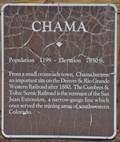 view gallery view gallerySW12.7 km | Chama in New Mexico Historical Markers This New Mexico Historical Marker is located on the east side of Terrace Avenue (New Mexico Highway 17) at 5th Street in Chama, New Mexico. posted by: brwhiz location: New Mexico date approved: 02/06/2013 last visited: never |
 view gallery view gallerySW12.7 km | Chama ~ Elevation 7850 Feet in Elevation Signs This New Mexico Historical Marker, with Population and Elevation, is located on the east side of Terrace Avenue (New Mexico Highway 17) at 5th Street in Chama, New Mexico. posted by: brwhiz location: New Mexico date approved: 02/06/2013 last visited: never |
 view gallery view gallerySW12.7 km | Chama ~ Population 1199 in Population Signs This New Mexico Historical Marker, with Population and Elevation, is located on the east side of Terrace Avenue (New Mexico Highway 17) at 5th Street in Chama, New Mexico. posted by: brwhiz location: New Mexico date approved: 02/06/2013 last visited: never |
 view gallery view gallerySW12.7 km |  Cumbres and Toltec Scenic Railroad, Chama NM Cumbres and Toltec Scenic Railroad, Chama NM
in Engineering Landmarks The Combres and Toltec Scenic railroad was added to the list of Historic Civil Engineering Landmarks as designated by the American Society of Civil Engineers in 1976. posted by: GT.US location: New Mexico date approved: 08/11/2011 last visited: 07/22/2011 |
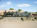 view gallery view gallerySW12.7 km | Cumbres & Toltec Scenic Railroad in Scenic Railroads The Cumbres and Toltec Scenic Railroad is both the highest and longest narrow gauge railroad in the United States. On its 64 mile trip, it crosses over the beautiful Cumbres Pass at 10,015 feet, posted by: DjARoswell location: New Mexico date approved: 07/01/2006 last visited: 07/22/2011 |
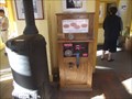 view gallery view gallerySW12.7 km |  Railroad Penny Smasher - Cumbres and Toltec scenic railroad - Chamas, NM Railroad Penny Smasher - Cumbres and Toltec scenic railroad - Chamas, NM
in Penny Smashers This penny smasher was found inside the Cumbres & Toltec Scenic railroad ticket office. posted by: GT.US location: New Mexico date approved: 08/15/2011 last visited: 06/08/2012 |
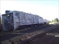 view gallery view gallerySW12.7 km | Rotary OY Snowplow - Cumbres and Toltec Scenic Railroad - Chama NM in Railroad Maintenance-Of-Way Equipment This Rotary Snowplow is on display in the yard of the Combres and Toltec scenic railroad. posted by: GT.US location: New Mexico date approved: 08/16/2011 last visited: never |
 view gallery view gallerySW12.7 km |  Denver & Rio Grande Railroad San Juan Extension ~ Chama, New Mexico Denver & Rio Grande Railroad San Juan Extension ~ Chama, New Mexico
in U.S. National Register of Historic Places The Denver & Rio Grande Railroad San Juan Extension, better known as the Cumbres & Toltec Scenic Railroad, has its southern terminus at the Chama station located at 500 Terrace Avenue in Chama, New Mexico. posted by: brwhiz location: New Mexico date approved: 02/06/2013 last visited: never |
|