 view gallery view gallery W3.2 km W3.2 km
|   Colorado City, Arizona 86021 & Hilldale, Utah 84784 Colorado City, Arizona 86021 & Hilldale, Utah 84784
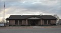
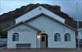
in U.S. Post Offices This Post Office is located at 55 S Central in Colorado City, Arizona. It serves two cities with two ZIP Codes in two different states!!! posted by:  brwhiz brwhiz location: Arizona date approved: 01/08/2012 last visited: never |
 view gallery view gallery SW3.5 km SW3.5 km
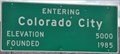
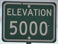
|  Colorado City ~ Elevation 5000 Feet Colorado City ~ Elevation 5000 Feet
in Elevation Signs This Elevation Sign is located on the northeast side of Arizona Highway 389 at the southern city limits of Colorado City, Arizona. posted by: brwhiz location: Arizona date approved: 05/20/2013 last visited: 03/04/2022 |
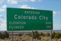 view gallery view galleryW5.5 km | Colorado City, Arizona - 5000 ft in Elevation Signs An elevation sign at the entrance to Colorado City, AZ. posted by: ggmorton location: Arizona date approved: 10/03/2007 last visited: 03/04/2022 |
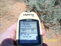 view gallery view galleryW5.8 km |  37 113 Colorado City, AZ 37 113 Colorado City, AZ
in Confluence Spots On the Arizona side of the border posted by:  Sanpitch Sanpitch location: Arizona date approved: 07/09/2008 last visited: 09/08/2013 |
 view gallery view gallery S7.1 km S7.1 km
| Elevation 5000 Feet in Elevation Signs This Elevation Sign is located on the northeast side of Arizona Highway 389, just southeast of Colorado City, Arizona. posted by: brwhiz location: Arizona date approved: 05/20/2013 last visited: 03/04/2022 |
 view gallery view gallery N15.1 km N15.1 km
|  George's Corner Restaurant - St. George , UT George's Corner Restaurant - St. George , UT
in Gluten Free Restaurants Very nice pub & grill in St. George posted by: Prying Pandora location: Utah date approved: 09/10/2013 last visited: never |
 view gallery view gallery E19.3 km E19.3 km
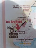
|  You are at Coral Pink Sand Dunes, Utah You are at Coral Pink Sand Dunes, Utah
in 'You Are Here' Maps This trio of information boards includes an all-important item: a YOU ARE HERE MAP.
N 37° 02.099 W 112° 43.883 posted by: Queens Blessing location: Utah date approved: 11/24/2012 last visited: 09/02/2013 |
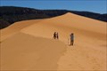 view gallery view galleryE19.3 km |  Coral Pink Sand Dunes State Park - Utah Coral Pink Sand Dunes State Park - Utah
in State/Provincial Parks Coral Pink Sand Dunes State Park - Utah posted by: kJfishman location: Utah date approved: 09/28/2010 last visited: 10/14/2012 |
 view gallery view gallery NW21.2 km NW21.2 km
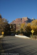
|  Rockville Bridge - 1924 - Rockville, Utah Rockville Bridge - 1924 - Rockville, Utah
in Bridge Date Stones and Plaques Old Historic Rockville bridge near the ghost town of Grafton, utah. posted by: The_Simpsons location: Utah date approved: 03/17/2011 last visited: 11/13/2013 |
 view gallery view galleryNW21.4 km |  Rockville, Utah ~ Population 247 Rockville, Utah ~ Population 247
in Population Signs Rockville is a sleepy little agricultural town astride the hevaily travelled highway leading to the southwest entrance to Zion National park. posted by: brwhiz location: Utah date approved: 04/05/2012 last visited: 11/12/2017 |
 view gallery view galleryNW21.4 km |  Virgin River Truss Bridge - Rockville, UT Virgin River Truss Bridge - Rockville, UT
in Truss Bridges The Rockville Bridge was built in 1924 and is the only surviving rigid Parker through truss type bridge in Utah. This bridge was the first link connecting motorists from Zion to the North Rim of the Grand Canyon. posted by: DopeyDuck location: Utah date approved: 05/14/2009 last visited: 09/29/2011 |
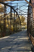 view gallery view galleryNW21.4 km |  Virgin River Bridge - Rockville, UT Virgin River Bridge - Rockville, UT
in Utah Historical Markers The Rockville Bridge was built in 1924 and is the only surviving rigid Parker through truss type bridge in Utah. This bridge was the first link connecting motorists from Zion to the North Rim of the Grand Canyon. posted by: DopeyDuck location: Utah date approved: 05/14/2009 last visited: 10/05/2013 |
 view gallery view galleryNW21.4 km |  Rockville Bridge - Rockville, UT Rockville Bridge - Rockville, UT
in U.S. National Register of Historic Places The Rockville Bridge was built in 1924 and is the only surviving rigid Parker through truss type bridge in Utah. This bridge was the first link connecting motorists from Zion to the North Rim of the Grand Canyon. posted by: DopeyDuck location: Utah date approved: 05/31/2009 last visited: 09/29/2011 |
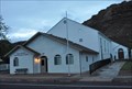 view gallery view galleryNW21.7 km | Rockville, Utah 84763 in U.S. Post Offices The tiny Rockville Post Office serves only 100 households in its ZIP Code area from its location at 43 E Main Street. posted by: brwhiz location: Utah date approved: 06/11/2011 last visited: 05/04/2018 |
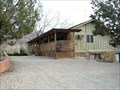
 view gallery view galleryNW21.7 km |  Rockville, Utah Rockville, Utah
in City and Town Halls Rockville Town Hall, located at 43 E Main Street, shares its building with the local US Post Office. posted by: brwhiz location: Utah date approved: 06/11/2011 last visited: 05/04/2018 |
 view gallery view galleryNW21.7 km |  Rockville, Utah Rockville, Utah
in Wikipedia Entries Rockville is a small former farming community of about 250 inhabitants located about 5 miles west of the entrance to Zion National Park. posted by: brwhiz location: Utah date approved: 06/11/2011 last visited: 05/04/2018 |
 view gallery view galleryN21.7 km |  Canyon Vista B&B - Springdale, UT Canyon Vista B&B - Springdale, UT
in Bed and Breakfast A relaxing place to stay near Zion National Park. posted by: Go Boilers! location: Utah date approved: 03/29/2009 last visited: 03/14/2011 |
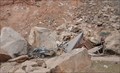 view gallery view galleryNW22 km |  Rock Slide Destroys Home, Kills Two in Rockville Rock Slide Destroys Home, Kills Two in Rockville
in News Article Locations On December 12, 2013 tons of dirt and rock separated from the face of a bluff and cascaded down onto a private home situated on the main highway leading to the southwest entrance to Zion National Park. posted by: brwhiz location: Utah date approved: 12/20/2013 last visited: never |
 view gallery view gallery SE22.2 km SE22.2 km
|  When the Good Grass Goes When the Good Grass Goes
in Arizona Historical Markers This Historical Marker is mounted on a steel post near one of the stone ranch buildings on the grounds of Pipe Spring National Monument about 15 miles west of Fredonia, Arizona. posted by: brwhiz location: Arizona date approved: 12/01/2012 last visited: 08/04/2014 |
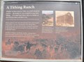 view gallery view gallerySE22.2 km | A Tithing Ranch in Arizona Historical Markers This Historical Marker is mounted on a steel post near one of the stone ranch buildings on the grounds of Pipe Spring National Monument about 15 miles west of Fredonia, Arizona. posted by: brwhiz location: Arizona date approved: 12/01/2012 last visited: 08/04/2014 |
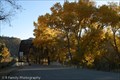
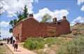 view gallery view gallerySE22.2 km |  Winsor Castle ~ Pipe Spring National Monument, Arizona Winsor Castle ~ Pipe Spring National Monument, Arizona
in Historic Forts This fortified ranch house is part of Pipe Springs National Monument, about 15 miles west of Fredonia, Arizona. posted by: brwhiz location: Arizona date approved: 11/27/2012 last visited: 08/04/2014 |
 view gallery view gallerySE22.2 km |  Ridge Trail ~ Pipe Spring National Monument Ridge Trail ~ Pipe Spring National Monument
in Flora and Fauna Information Signs This Flora and Fauna Information Sign is located at the start of the Ridge Trail on Pipe Spring National Monument west of Fredonia, Arizona. posted by: brwhiz location: Arizona date approved: 11/26/2012 last visited: 08/04/2014 |
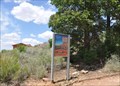 view gallery view gallerySE22.2 km |  Ridge Trail ~ Pipe Spring National Monument Ridge Trail ~ Pipe Spring National Monument
in Hiking and walking trailheads Ridge Trail climbs to the top of the bluff overlooking Pipe Spring National Monument west of Fredonia, Arizona. posted by: brwhiz location: Arizona date approved: 11/19/2012 last visited: 08/04/2014 |
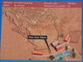 view gallery view gallerySE22.2 km | Ridge Trail Trailhead ~ Pipe Spring National Monument in 'You Are Here' Maps You Are Here at the Ridge Trail Information Sign at Pipe Spring National Monument west of Fredonia, Arizona. posted by: brwhiz location: Arizona date approved: 11/19/2012 last visited: 08/04/2014 |
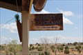 view gallery view gallerySE22.2 km |  FIRST -- Telegraph in AZ, Pipe Spring Natl. Mon., Kaibab AZ FIRST -- Telegraph in AZ, Pipe Spring Natl. Mon., Kaibab AZ
in First of its Kind The Desert Telegraph, which linked the Mormon pioneer outpost of Pipe Spring with Salt Lake City and then the world, commenced operations in 1871. posted by: Benchmark Blasterz location: Arizona date approved: 08/26/2014 last visited: 08/27/2014 |
|