 view gallery view gallery E2.1 km E2.1 km
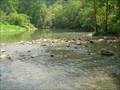
|   CONFLUENCE - Big Cedar Creek and Clinch River, VA CONFLUENCE - Big Cedar Creek and Clinch River, VA
in River Origins, Destinations and Confluences The Clinch River flows down from Tazewell, VA to the Tennessee border. At this point, the Big Cedar Creek flowing from SE of Lebanon, VA joins into the Clinch River. posted by:  vhasler vhasler location: Virginia date approved: 08/21/2010 last visited: never |
 view gallery view gallery SE2.6 km SE2.6 km
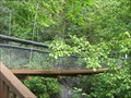
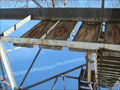
|  Swinging Bridge at Pinnacle Natural Area Preserve, VA Swinging Bridge at Pinnacle Natural Area Preserve, VA
in Pedestrian Suspension Bridges A sturdy suspension bridge over the Big Cedar Creek posted by: vhasler location: Virginia date approved: 08/15/2010 last visited: never |
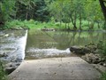 view gallery view gallerySE2.7 km |  Ford of Big Cedar Creek in Pinnacle Natural Area Preserve, VA Ford of Big Cedar Creek in Pinnacle Natural Area Preserve, VA
in Bridgeless Water Crossings The park road fords through the Big Cedar Creek posted by: vhasler location: Virginia date approved: 08/28/2010 last visited: never |
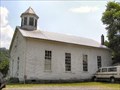
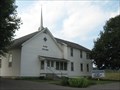 view gallery view gallerySE3.9 km |  Oak Grove Baptist Church - Lebanon, VA Oak Grove Baptist Church - Lebanon, VA
in Baptist Churches A white Baptist church out in the Virginia country posted by: vhasler location: Virginia date approved: 08/21/2010 last visited: never |
 view gallery view gallery S7.7 km S7.7 km
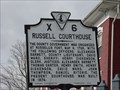
|  Russell County Courthouse - Lebanon, Virginia Russell County Courthouse - Lebanon, Virginia
in Courthouses The Russell County Courthouse stands on Main Street in Lebanon, Virginia. posted by: Sneakin Deacon location: Virginia date approved: 11/20/2008 last visited: 10/29/2016 |
 view gallery view galleryS7.7 km |  Russell Courthouse Russell Courthouse
in Virginia Historical Markers This historic marker stands on the grounds of the Russell County Courthouse in Lebanon, Virginia posted by: Sneakin Deacon location: Virginia date approved: 11/19/2008 last visited: 10/29/2016 |
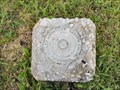
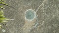 view gallery view galleryS7.7 km |  GA0354 ~ Lebanon, Virginia. GA0354 ~ Lebanon, Virginia.
in U.S. Benchmarks A 1963 U.S. Coast & Geodetic Survey azimuth disk. posted by:  Manville Possum Manville Possum location: Virginia date approved: 11/03/2016 last visited: 12/30/2019 |
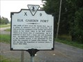 view gallery view galleryE10.3 km | Elk Garden Fort in Virginia Historical Markers Near here was Elk Garden Fort which protected settlers from Indian attacks. posted by: vhasler location: Virginia date approved: 08/15/2010 last visited: 05/15/2016 |
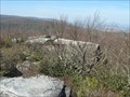 view gallery view gallerySE13.8 km |  The Great Channels - Hayters Gap, VA The Great Channels - Hayters Gap, VA
in Places of Geologic Significance The Great Channels are named for the maze of large sandstone boulders and eroded crevices in the Channels Nature Area Preserve. posted by: vhasler location: Virginia date approved: 03/22/2010 last visited: 11/11/2012 |
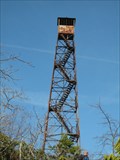 view gallery view gallerySE14 km | FZ2178 - HAYTER KNOB LOOKOUT TOWER - Virginia in U.S. Benchmarks Firetower in NGS database, but without description. posted by: vhasler location: Virginia date approved: 03/21/2010 last visited: 11/11/2012 |
 view gallery view gallerySE14 km |  Hayter Firetower - CCC P53VA - Channel NAP, VA Hayter Firetower - CCC P53VA - Channel NAP, VA
in Civilian Conservation Corps Firetower was built by CCC Camp P53VA posted by: vhasler location: Virginia date approved: 03/24/2010 last visited: 11/11/2012 |
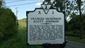 view gallery view gallerySE14 km | Frances Dickenson Scott Johnson in Virginia Historical Markers A Virginia Historical Marker placed by the Department of Conservation and Historic Resources in 1986. posted by: Manville Possum location: Virginia date approved: 05/15/2016 last visited: 12/30/2019 |
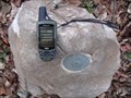 view gallery view gallerySE16.4 km | TVA Survey Marker - Hayter's Gap, Va. in U.S. Benchmarks A 1937 Tennessee Valley Authority Survey Marker in Washington County, Virginia. posted by: Manville Possum location: Virginia date approved: 11/26/2012 last visited: 12/30/2019 |
 view gallery view gallery SW20.8 km SW20.8 km
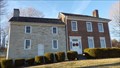
|  Old Russell County Courthouse Old Russell County Courthouse
in U.S. National Register of Historic Places The Old Russell County Courthouse. posted by: Manville Possum location: Virginia date approved: 04/13/2014 last visited: 12/30/2019 |
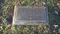 view gallery view gallerySW20.9 km |  Henry Dickenson ~ Old Russell County Courthouse Cemetery ~ Dickensonville, Virginia. Henry Dickenson ~ Old Russell County Courthouse Cemetery ~ Dickensonville, Virginia.
in American Revolutionary War Veteran Graves Grave of Henry Dickenson, an American Revolutionary War Soilder. posted by: Manville Possum location: Virginia date approved: 04/15/2014 last visited: 12/30/2019 |
 view gallery view gallerySW20.9 km |  LOVEwork in Russell County ~ Castlewood, Virginia - USA. LOVEwork in Russell County ~ Castlewood, Virginia - USA.
in Silhouette Public Art Sculptures Located on the grounds of the historic Old Russell County Courthouse and Dickenson Bundy Log House, this LOVEwork was created with great pride by the 2016-2017 welding class of the Russell County Career and Technical Center. posted by: Manville Possum location: Virginia date approved: 01/16/2020 last visited: 01/16/2020 |
 view gallery view gallerySW20.9 km | Old Russell County Courthouse in Virginia Historical Markers A Virginia Historical Marker placed in 1986 by the Department of Conservation and Historic Resources. posted by: Manville Possum location: Virginia date approved: 02/22/2014 last visited: 12/30/2019 |
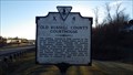
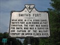 view gallery view galleryE20.9 km | Smith's Fort in Virginia Historical Markers This historic marker is located on U. S. Route 19, east of the Belfast Community in Russell County, Virginia. posted by: Sneakin Deacon location: Virginia date approved: 06/23/2008 last visited: never |
 view gallery view galleryS21.6 km |  Corner House Church - Holston, Virginia Corner House Church - Holston, Virginia
in Country Churches One mile West of Rte. 19 on Mendota road. North East of Abingdon, Virignia. posted by: UberHOKIE location: Virginia date approved: 06/26/2008 last visited: never |
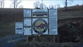
 view gallery view galleryS21.6 km | TVA Survey Marker LHT 249. Holston, Virginia in U.S. Benchmarks Found this by complete accident while taking pictures of the old church for another waymark category.
Marker is not in fantastic shape but you can read it. posted by: UberHOKIE location: Virginia date approved: 06/28/2008 last visited: never |
 view gallery view gallery W21.9 km W21.9 km
|  Spearhead Trails ~ Mountian View ~ St. Paul, VA. Spearhead Trails ~ Mountian View ~ St. Paul, VA.
in Offroad Trails Spearhead Trails is the exciting new trail destination in Southwest Virginia. posted by: Manville Possum location: Virginia date approved: 03/13/2014 last visited: 12/30/2019 |
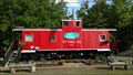 view gallery view galleryW22 km |  Caboose ~ St Paul, Virginia. Caboose ~ St Paul, Virginia.
in Train Cabooses Caboose used as rafting adventure business in St Paul, Virginia. posted by: Manville Possum location: Virginia date approved: 06/09/2017 last visited: 12/30/2019 |
 view gallery view galleryW22.7 km | Wise County/Russell County in Virginia Historical Markers A Virginia Historical Marker placed in 2003 by the Department of Historic Resources. posted by: Manville Possum location: Virginia date approved: 06/20/2016 last visited: 12/30/2019 |
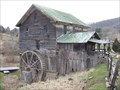 view gallery view galleryS23.8 km | White's Mill - Abingdon, VA in U.S. National Register of Historic Places 1820's grist mill now open for public viewing located 4.2 miles north of Abingdon posted by: vhasler location: Virginia date approved: 03/23/2010 last visited: never |
 view gallery view galleryS23.8 km |  White's Mill - Abingdon, VA White's Mill - Abingdon, VA
in Water Mills 1820's grist mill now open for public viewing located 4.2 miles north of Abingdon posted by: vhasler location: Virginia date approved: 03/25/2010 last visited: never |
|