 view gallery view gallery E14 km E14 km
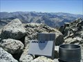
|   Arrow Peak Arrow Peak
in Summit Registers Arrow Peak summit, elevation 12959 feet, located in Kings Canyon National Park. It is often photographed from Bench Lake, known for its mirror-like surface at dawn reflecting the image of the peak. posted by:  atc atc location: California date approved: 01/28/2006 last visited: never |
 view gallery view gallery N16.6 km N16.6 km
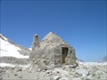
|  John Muir Memorial Shelter John Muir Memorial Shelter
in Remote Backcountry Shelters One of the most well known huts along the John Muir Trail. It is now only intended as an emergency survival shelter as general overnight traffic is prohibited. posted by: hyperheidi location: California date approved: 09/28/2011 last visited: never |
 view gallery view gallery SW19.8 km SW19.8 km
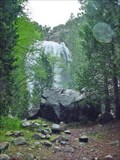
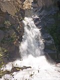
|  Grizzly Falls, California Grizzly Falls, California
in Waterfalls Impressive tributary to the Kings River posted by:  Bernd das Brot Team Bernd das Brot Team location: California date approved: 05/17/2008 last visited: 06/21/2012 |
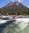
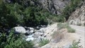 view gallery view gallerySW22.7 km |  KINGS RIVER, CALIFORNIA KINGS RIVER, CALIFORNIA
in National Wild and Scenic Rivers KINGS RIVER is located in Kings Canyon National Park, CA posted by: tatie location: California date approved: 11/16/2013 last visited: 09/10/2017 |
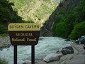 view gallery view gallerySW22.7 km | ") Boyden Cavern, California Boyden Cavern, California
in Cave Entrances (Natural) Cave in Kings Canyon posted by: Bernd das Brot Team location: California date approved: 04/29/2008 last visited: never |
 view gallery view gallerySW24.9 km |  CONFLUENCE - Kings River South and Middle Fork CONFLUENCE - Kings River South and Middle Fork
in River Origins, Destinations and Confluences Junction of the two main forks of California's Kings River posted by: Bernd das Brot Team location: California date approved: 04/27/2008 last visited: never |
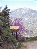
 view gallery view gallerySW25.4 km |  Yucca Point Trail, Kings Canyon, California Yucca Point Trail, Kings Canyon, California
in Trail Registers The trail leads from hwy 180 down to the Kings River. posted by: Bernd das Brot Team location: California date approved: 05/24/2006 last visited: 02/02/2019 |
 view gallery view gallerySW25.6 km |  Yucca Point Trail, Kings Canyon, CA Yucca Point Trail, Kings Canyon, CA
in Scenic Hikes A steep trail from Kings Canyon Road down to Kings River posted by: Bernd das Brot Team location: California date approved: 05/19/2008 last visited: never |
 view gallery view gallerySW25.6 km | Tenmile Creek Cascades in Waterfalls A short, cascading river in Kings Canyon posted by: Bernd das Brot Team location: California date approved: 05/17/2008 last visited: never |
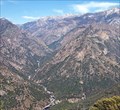 view gallery view gallerySW26.4 km |  Junction View, Kings Canyon, CA Junction View, Kings Canyon, CA
in Scenic Roadside Look-Outs The best place to see Kings Canyon posted by: Bernd das Brot Team location: California date approved: 05/20/2008 last visited: 07/28/2013 |
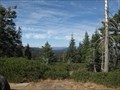
 view gallery view gallery S26.4 km S26.4 km
|  Mitchell Peak Mitchell Peak
in Mountain Summits Beautiful hike and wonderful site in Kings Canyon National Park. posted by: wilsonjw location: California date approved: 08/30/2005 last visited: never |
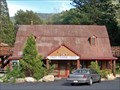
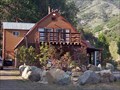 view gallery view gallerySW27 km |  Kings Canyon Lodge & Cabins, Kings Canyon, California Kings Canyon Lodge & Cabins, Kings Canyon, California
in Chalet, Cottage, and Cabin Style Lodging The oldest lodge in Kings Canyon posted by: Bernd das Brot Team location: California date approved: 05/18/2008 last visited: never |
 view gallery view gallerySW27 km | Kings Canyon Lodge, Kings Canyon, California in Lodge-Style Accommodations The oldest lodge in Kings Canyon posted by: Bernd das Brot Team location: California date approved: 05/28/2008 last visited: never |
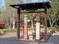 view gallery view gallerySW27 km |  Kings Canyon Lodge Gas Station Kings Canyon Lodge Gas Station
in Vintage Gas Stations America's oldest gravity pump posted by: Bernd das Brot Team location: California date approved: 05/19/2008 last visited: 06/21/2012 |
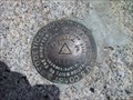
 view gallery view galleryN29.9 km |  27_KSM 27_KSM
in U.S. Benchmarks Located on the shore near Loch Leven lake along the North Fork of Bishop Creek. It's about a four mile walk to this disk but well worth the views. posted by: Touchstone location: California date approved: 09/10/2006 last visited: 10/03/2008 |
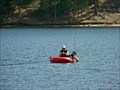 view gallery view gallerySW30.3 km |  Hume Lake, California Hume Lake, California
in Fishing Holes Reservoir in Kings Canyon posted by: Bernd das Brot Team location: California date approved: 05/17/2008 last visited: 09/06/2010 |
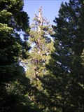 view gallery view gallerySW31.4 km |  Boole Tree Boole Tree
in Exceptional Trees The Boole Tree, eighth largest tree in the world posted by: Daniel Nestlerode location: California date approved: 07/07/2008 last visited: 02/20/2018 |
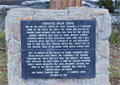 view gallery view gallerySW34.9 km |  Converse Basin Grove Converse Basin Grove
in E Clampus Vitus Historical Markers E Clampus Vitus marker, commemorating a grove of Giant Sequoia trees that was cut in 1907. posted by: Bernd das Brot Team location: California date approved: 05/10/2011 last visited: never |
 view gallery view gallerySW35.2 km | Kings Canyon Overlook - Kings Canyon National Park, CA in Scenic Roadside Look-Outs The Kings Canyon Overlook is located on the Generals Highway 198 in Kings Canyon National Park, about 6 miles south of General Grant Tree. posted by: Merlin-N-Mim location: California date approved: 10/24/2009 last visited: 07/02/2014 |
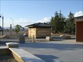 view gallery view galleryE35.9 km |  Division Creek Rest Area - 395NB - CA Division Creek Rest Area - 395NB - CA
in Highway Rest Areas A quiet rest stop with easy on & off access to the highway. posted by: Free2bme29 location: California date approved: 07/08/2009 last visited: 09/16/2021 |
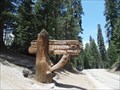
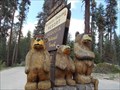 view gallery view gallerySW35.9 km |  Mantecito bears - Sequoia National Forest CA Mantecito bears - Sequoia National Forest CA
in Outside Wooden Display Carvings The three bears. Signify an all season lodge. It does not welcome pets. posted by: sbcamper location: California date approved: 06/15/2015 last visited: never |
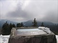 view gallery view gallerySW36.7 km |  The World's Largest Sequoia Grove - Sequoia National Park, California USA The World's Largest Sequoia Grove - Sequoia National Park, California USA
in Orientation Tables Orientation table along the General's Highway in Sequoia National Park. posted by: fishingwishing location: California date approved: 03/09/2009 last visited: 10/24/2013 |
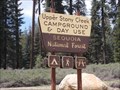 view gallery view gallerySW37.2 km |  Upper Stony Creek - National Forest - Sequoia, CA Upper Stony Creek - National Forest - Sequoia, CA
in Campgrounds Open after May 31 til Sept. conditions allowing. Day use area also. posted by: sbcamper location: California date approved: 05/21/2015 last visited: never |
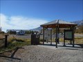 view gallery view galleryS37.2 km |  Eastern Sierra Visitor Center, Inyo N. F. - Long Pine CA Eastern Sierra Visitor Center, Inyo N. F. - Long Pine CA
in Tourist Information Centers - Visitor Centers Thirteen of the peaks over 14,000 feet are in Inyo County. Permits are required for Wilderness access and trails.
There is a picnic area, bookstore and gift shop, area maps. posted by: sbcamper location: California date approved: 08/14/2022 last visited: never |
 view gallery view gallerySW37.3 km |  Sequoia National Forest - Tulare / Kings County CA Sequoia National Forest - Tulare / Kings County CA
in Public Access Lands National Forest land, separate from the National Park that adjoins it. On the western slope of the Sierra Nevada Mountain Range in the southern end of the state. It includes Sequoia National Monument and Sequoia / Kings National Park. posted by: sbcamper location: California date approved: 06/21/2016 last visited: never |
|