 view gallery view gallery NW23 km NW23 km
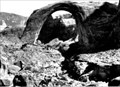
|   1910s & 2014 -- Rainbow Bridge National Monument, UT 1910s & 2014 -- Rainbow Bridge National Monument, UT
in Photos Then and Now Two photos of Rainbow Bridge, one from the 19-teens and the other from 2014, show subtle differences around this amazing landform posted by:  Benchmark Blasterz Benchmark Blasterz location: Utah date approved: 08/28/2014 last visited: 08/29/2014 |
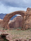
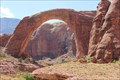 view gallery view galleryNW23 km |  Rainbow Bridge -- Rainbow Bridge National Monument, UT Rainbow Bridge -- Rainbow Bridge National Monument, UT
in Places of Geologic Significance The amazing Rainbow Bridge has been carved over millions of years by water and time, on display at the Rainbow Bridge National Monument. The waymark coordinates are for the closest public viewing area. posted by: Benchmark Blasterz location: Utah date approved: 08/28/2014 last visited: 11/02/2023 |
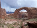 view gallery view galleryNW23.2 km | ") Rainbow Bridge National Monument Rainbow Bridge National Monument
in National Parks (U.S.) Located on Lake Powell in Glen Canyon, Rainbow Bridge is the world's largest known natural bridge. Accessible by foot or boat. posted by: run26.2 location: Utah date approved: 06/09/2009 last visited: 08/01/2014 |
 view gallery view galleryNW23.2 km |  Rainbow Bridge National Monument Rainbow Bridge National Monument
in National Parks of the World Located on Lake Powell in Glen Canyon, Rainbow Bridge is the world's largest known natural bridge. Accessible by foot or boat. posted by: run26.2 location: Utah date approved: 06/10/2009 last visited: 08/01/2014 |
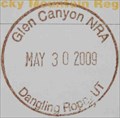
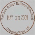 view gallery view galleryNW23.2 km |  Rainbow Bridge National Monument - Dangling Rope, UT -- Dangling Rope Marina Rainbow Bridge National Monument - Dangling Rope, UT -- Dangling Rope Marina
in NPS Passport Cancellation Stations Located on Lake Powell in Glen Canyon, Rainbow Bridge is the world's largest known natural bridge. Accessible by foot or boat.
I received my stamp at the Dangling Rope Marnia on Lake Powell. posted by: run26.2 location: Utah date approved: 06/05/2009 last visited: 05/30/2009 |
 view gallery view galleryNW23.2 km |  Rainbow Bridge Rainbow Bridge
in Natural Arches Located on Lake Powell in Glen Canyon, Rainbow Bridge is the world's largest known natural bridge. posted by: run26.2 location: Utah date approved: 06/06/2009 last visited: 08/01/2014 |
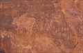 view gallery view galleryNW23.5 km |  Petroglyphs -- Rainbow Bridge Natl. Monument, UT Petroglyphs -- Rainbow Bridge Natl. Monument, UT
in Pictographs Navajo Petroglyphs at a seep spring on the trail to the Rainbow Bridge from Lake Powell posted by: Benchmark Blasterz location: Utah date approved: 09/25/2014 last visited: 09/26/2014 |
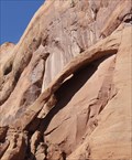 view gallery view galleryNW24.1 km | Thin Arch -- Rainbow Bridge National Monument, UT in Natural Arches A thin arch located on the side of the canyon near the boat dock at Rainbow Bridge National Monument posted by: Benchmark Blasterz location: Utah date approved: 08/25/2014 last visited: 11/02/2023 |
 view gallery view galleryNW34.1 km |  Dangling Rope Marina, Lake Powell, Utah Dangling Rope Marina, Lake Powell, Utah
in Web Cameras Dangling Rope Marina located in the heart of lake Powell. Great place to stop to refuel, restock and visit with a Ranger. posted by: run26.2 location: Utah date approved: 06/11/2009 last visited: 06/01/2009 |
 view gallery view galleryNW34.4 km | Glen Canyon NRA - Dangling Rope, UT -- Dangling Rope Marina in NPS Passport Cancellation Stations Glen Canyon National Recreation Area encompasses Lake Powell and the surrounding area in Arizona and Utah. posted by: run26.2 location: Utah date approved: 06/05/2009 last visited: 11/11/2023 |
 view gallery view galleryNW34.4 km |  Glen Canyon National Recreation Area: Dangling Rope Ranger Station Glen Canyon National Recreation Area: Dangling Rope Ranger Station
in Ranger Stations The Dangling Rope Marina Ranger Station is located 41 miles upstream from the Glen Canyon dam in the Glen Canyon National Recreation Area. posted by: run26.2 location: Utah date approved: 06/05/2009 last visited: 11/11/2023 |
 view gallery view gallery SE35.4 km SE35.4 km
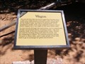
|  Wagon-Navajo National Monument - Shonto AZ Wagon-Navajo National Monument - Shonto AZ
in Arizona Historical Markers You can tell that this two-horse wagon has traveled many a mile over rough Navajo reservation roads. One of the many styles made around the turn of the century specifically for the Indian trade, and sold at trading posts. posted by:  Don.Morfe Don.Morfe location: Arizona date approved: 11/19/2020 last visited: 10/23/2021 |
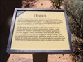 view gallery view gallerySE35.4 km | Hogan Navajo National Monument - Shonto AZ in Arizona Historical Markers The Navajo Indians resourcefully met the demands of desert dwelling when they came up with this comfortable and sturdy forked-stick hogan — so called because its chief structural support is made up of three poles with their forked ends interlocked. posted by: Don.Morfe location: Arizona date approved: 11/19/2020 last visited: 02/17/2022 |
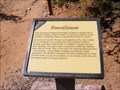 view gallery view gallerySE35.4 km | Sweathouse Navajo National Monument - Shonto AZ in Arizona Historical Markers This miniature forked-stick hogan without a smoke hole is actually a highly effective bath — an ancient solution to the problem of keeping clean in a land where water is scarce. posted by: Don.Morfe location: Arizona date approved: 11/19/2020 last visited: 02/17/2022 |
 view gallery view gallerySE35.4 km |  Navajo National Monument - Shonto AZ Navajo National Monument - Shonto AZ
in Official Local Tourism Attractions Navajo National Monument is a National Monument located within the northwest portion of the Navajo Nation territory in northern Arizona, which was established to preserve three well-preserved cliff dwellings of the Ancestral Puebloan people. posted by: Don.Morfe location: Arizona date approved: 02/16/2022 last visited: 02/17/2022 |
 view gallery view gallerySE35.4 km |  Navajo National Monument - Shonto AZ Navajo National Monument - Shonto AZ
in Wikipedia Entries Navajo National Monument is a National Monument located within the northwest portion of the Navajo Nation territory in northern Arizona, which was established to preserve three well-preserved cliff dwellings of the Ancestral Puebloan people. posted by: Don.Morfe location: Arizona date approved: 02/16/2022 last visited: 02/17/2022 |
 view gallery view gallerySE35.4 km | Navajo National Monument - Shonto AZ in Ranger Stations The visitor center has a ranger station, a museum, three short self-guided trails, two small campgrounds, and a picnic area. posted by: Don.Morfe location: Arizona date approved: 02/17/2022 last visited: 02/17/2022 |
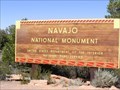 view gallery view gallerySE35.4 km |  Navajo National Monument - Kayenta AZ Navajo National Monument - Kayenta AZ
in Satellite Imagery Oddities Navajo National Monument is a National Monument located within the northwest portion of the Navajo Nation territory in northern Arizona, which was established to preserve three well-preserved cliff dwellings of the Ancestral Puebloan people. posted by: Don.Morfe location: Arizona date approved: 02/16/2022 last visited: 02/17/2022 |
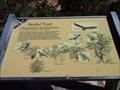 view gallery view gallerySE35.4 km |  Sandal Trail - Navajo National Monument, AZ Sandal Trail - Navajo National Monument, AZ
in Hiking and walking trailheads The Sandal Trail is a paved trail which leads to the overlook of Betatakin/Talastima cliff dwelling (1-mile round trip). posted by: RakeInTheCache location: Arizona date approved: 10/30/2016 last visited: 04/30/2020 |
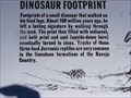 view gallery view gallerySE35.4 km | Dinosaur Footprint Navajo National Monument - Shonto AZ in Arizona Historical Markers Footprints of a small dinosaur that walked on his hind legs. About 180 million years ago, he left a lasting signature by walking through the mud. posted by: Don.Morfe location: Arizona date approved: 11/19/2020 last visited: 10/23/2021 |
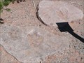 view gallery view gallerySE35.4 km |  Dinosaur Footprints - Navajo National Monument - Shonto AZ Dinosaur Footprints - Navajo National Monument - Shonto AZ
in Petrosomatoglyphs These petrosomatoglyphs (footprints) are near the Visitors Center for the Betatakin Ruins in the Navajo National Monument. It's at the end of State Highway 564 off of US Highway 160. posted by: PeterNoG location: Arizona date approved: 12/13/2011 last visited: 10/13/2018 |
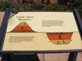 view gallery view gallerySE35.4 km | Upside-down Mountain Navajo National Monument - Shonto AZ in Arizona Historical Markers Hidden away in Tsegi Canyon’s wilderness of bare rock, sand, and sparse vegetation are surprising pockets of luxuriant growth. Betatakin Canyon—home to a village of prehistoric cliff-dwellings farmers—is one of these oases. posted by: Don.Morfe location: Arizona date approved: 11/19/2020 last visited: 10/23/2021 |
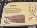 view gallery view gallerySE35.4 km | Canyons in Time Navajo National Monument - Shonto AZ in Arizona Historical Markers The maze of canyonlands stretching before you is the continuing work of millions of years of powerful and pervasive geological forces. posted by: Don.Morfe location: Arizona date approved: 11/19/2020 last visited: 10/23/2021 |
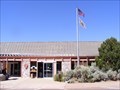
 view gallery view gallerySE35.4 km | Navajo National Monument - Shonto, AZ, Visitor Center in NPS Passport Cancellation Stations National Parks Passport Cancellation Station at Navajo National Monument Visitor Center, Shonto, AZ. posted by: NakoTacoPatrol location: Arizona date approved: 08/26/2013 last visited: 10/13/2018 |
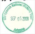 view gallery view gallerySE35.4 km | Old Spanish National Historic Trail - Shonto, AZ in NPS Passport Cancellation Stations This NPS Passport Cancellation Stamp was obtained at the Navajo National Monument Visitor Center.
An Arduous Adventure of Rich Trade-Follow the routes of mule pack trains across the Southwest on the Old Spanish National Historic Trail. posted by: Don.Morfe location: Arizona date approved: 02/25/2020 last visited: 10/10/2021 |
|