 view gallery view gallery E5.3 km E5.3 km
|   Star of Bethlehem - Rose Hill, VA Star of Bethlehem - Rose Hill, VA
in Painted Barn Quilts Just barely seen when heading west on Daniel Boone Trail Highway US58. posted by:  vhasler vhasler location: Virginia date approved: 08/20/2011 last visited: never |
 view gallery view gallery SW6.8 km SW6.8 km
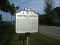
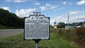
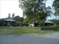
|  Martin's Station Martin's Station
in Virginia Historical Markers A Virginia historical marker placed near the site of Martin's Station along the Wilderness Road to Kentucky. posted by:  Manville Possum Manville Possum location: Virginia date approved: 08/31/2010 last visited: 12/30/2019 |
 view gallery view gallery W9.3 km W9.3 km
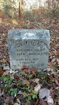
|  Henry Long ~ Rose Hill, Virginia. Henry Long ~ Rose Hill, Virginia.
in Homemade Tombstones Henry Long and others in a small family cemetery in a very remote area on top of Stone mountain near Rose Hill. posted by: Manville Possum location: Virginia date approved: 11/03/2016 last visited: 12/30/2019 |
 view gallery view gallery NE10.9 km NE10.9 km
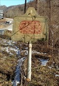
|  Civil War Routes ~ Harlan County ~ Cranks, KY. Civil War Routes ~ Harlan County ~ Cranks, KY.
in Kentucky Historical Markers A Kentucky Historical marker placed by the Kentucky Historical Society and Kentucky Department of Highways in 1962. posted by: Manville Possum location: Kentucky date approved: 03/03/2016 last visited: 12/30/2019 |
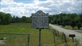
 view gallery view gallerySW11.6 km |  Daniel Boone Trail Marker in Rose Hill, Virginia. Daniel Boone Trail Marker in Rose Hill, Virginia.
in Wagon Roads and Trails A Daniel Boone Trail Marker placed by the Virginia Daughters of the American Revolution. posted by: Manville Possum location: Virginia date approved: 08/31/2010 last visited: 12/30/2019 |
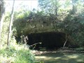
 view gallery view gallerySW11.7 km |  Ely Indian Mound at Rose Hill, Virginia Ely Indian Mound at Rose Hill, Virginia
in U.S. National Register of Historic Places A Native Americian Mound along the Wilderness Road to Kentucky. posted by: Manville Possum location: Virginia date approved: 09/03/2010 last visited: 12/30/2019 |
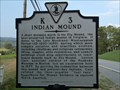 view gallery view gallerySW11.7 km | Indian Mound in Virginia Historical Markers A Virginia Historical Marker near a Native Americian Mound in Rose Hill Virginia along the Wilderness Road to Kentucky. posted by: Manville Possum location: Virginia date approved: 08/31/2010 last visited: 12/30/2019 |
 view gallery view galleryE12.4 km | Natural Bridge Shelter along the Daniel Boone Trail in Wagon Roads and Trails The Wilderness Trail crossed Batie Creek here at this natural bridge. posted by: Manville Possum location: Virginia date approved: 09/27/2010 last visited: 12/31/2019 |
 view gallery view gallery N12.6 km N12.6 km
|  Jesus is Coming Soon ~ Harlan, Kentucky Jesus is Coming Soon ~ Harlan, Kentucky
in Silhouette Public Art Sculptures A historic Henry Harrison Mayes roadside art marker made of concrete in the silhouette of a heart proclaiming that Jesus is coming soon. posted by: Manville Possum location: Kentucky date approved: 10/25/2017 last visited: 01/30/2020 |
 view gallery view galleryE12.7 km | Doctor Still's Birthplace in Virginia Historical Markers A local roadside historical marker dated 1979 placed at Dr. Still Park in Lee County, near the town of Jonesville. posted by: Manville Possum location: Virginia date approved: 06/09/2014 last visited: 12/30/2019 |
 view gallery view gallerySW12.9 km | William H. Starnes: Agricultural Educator in Virginia Historical Markers A Virginia Historical Marker placed by the Department of Historic Resources in 2013. posted by: Manville Possum location: Virginia date approved: 06/09/2014 last visited: 12/30/2019 |
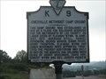 view gallery view galleryE13 km | Jonesville Methodist Camp Ground in Virginia Historical Markers 200 years ago, this UMC camp ground was founded in 1810 posted by: vhasler location: Virginia date approved: 07/09/2010 last visited: 08/29/2010 |
 view gallery view galleryE13 km | Jonesville Methodist Camp Ground - Jonesville, VA in U.S. National Register of Historic Places An old Methodist Camp Ground, established in 1810. posted by: Manville Possum location: Virginia date approved: 08/31/2010 last visited: 12/31/2019 |
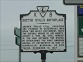 view gallery view galleryE14.3 km | Doctor Still's Birthplace in Virginia Historical Markers Located on U.S. Hwy 58 E. just outside Jonesville. posted by: fatcat161 location: Virginia date approved: 05/20/2009 last visited: 09/23/2010 |
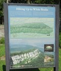
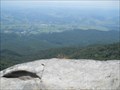 view gallery view gallerySW14.5 km |  Sand Cave and White Rocks - Ewing, VA Sand Cave and White Rocks - Ewing, VA
in Scenic Hikes An 8.5 mile loop hike up Cumberland Mountain to see wind-carved Sand Cave and then over to White Rocks to view the Wilderness Road like Daniel Boone. posted by: vhasler location: Virginia date approved: 08/26/2011 last visited: never |
 view gallery view gallerySW14.5 km |  Ewing Trail - Ewing, VA Ewing Trail - Ewing, VA
in Hiking and walking trailheads Steep 3.6 mile hiking/horse trail used to reach Sand Cave and White Rocks overlook in Cumberland Gap NHP. posted by: vhasler location: Virginia date approved: 08/28/2011 last visited: never |
 view gallery view galleryE14.6 km |  Jonesville Middle School bulldogs Jonesville Middle School bulldogs
in School Mascots Go, Bulldogs! posted by: vhasler location: Virginia date approved: 07/05/2010 last visited: 09/14/2010 |
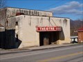 view gallery view gallerySW15 km |  Ewing Theater Ewing Theater
in Vintage Movie Theaters Long abandoned theater in Lee County, VA. posted by: Wallyum location: Virginia date approved: 03/28/2021 last visited: never |
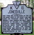 view gallery view galleryE15.1 km | Jonesville in Virginia Historical Markers This marker is located on Route 58 entering Jonesville from the east, and relates the early history of the town. posted by: silverquill location: Virginia date approved: 05/19/2008 last visited: 09/23/2010 |
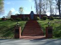 view gallery view galleryE15.4 km |  Lee County Veterans Memorial Wall - Jonesville, Virginia. Lee County Veterans Memorial Wall - Jonesville, Virginia.
in Non-Specific Veteran Memorials A veterans memorial wall in Cumberland Bowl Park at Jonesville,Virginia. posted by: Manville Possum location: Virginia date approved: 06/08/2011 last visited: 12/30/2019 |
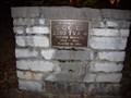 view gallery view galleryE15.4 km |  C.C.C. Co. 2380 T.V.A. 4 C.C.C. Co. 2380 T.V.A. 4
in Civilian Conservation Corps A CCC memorial in the Lee County, Virginia Veterans Memorial Park. posted by: Manville Possum location: Virginia date approved: 01/07/2011 last visited: 12/30/2019 |
 view gallery view galleryE15.6 km | "BP" Starburst - Jonesville, VA in Painted Barn Quilts Starburst pattern on a private garage posted by: vhasler location: Virginia date approved: 06/05/2012 last visited: never |
 view gallery view galleryNE15.8 km | Lee County Virginia in Virginia Historical Markers This historical marker is located on Route 421 as one enters Virginia from Kentucky to the west. posted by: silverquill location: Virginia date approved: 01/21/2013 last visited: 02/11/2016 |
 view gallery view galleryNE15.8 km |  Welcome to Virgnia Welcome to Virgnia
in Artistic Welcome Signs This colorful welcome sign greets visitors entering the state of Virginia traveling east from Kentucky on Route 421 posted by: silverquill location: Virginia date approved: 01/18/2013 last visited: never |
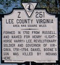 view gallery view galleryNE15.8 km |  Lee County - Virginia, U.S.A. Lee County - Virginia, U.S.A.
in People-Named Places Lee County Virginia is located in the extreme southwest corner of the state. It was named for Henry "Lighthorse" Lee, revolutionary soldier, former governor of the state, and father of the Confederate General Robert E. Lee. posted by: silverquill location: Virginia date approved: 01/20/2013 last visited: never |
|