 view gallery view gallery W5.1 km W5.1 km
|   Industrial Education Centers | J-113 Industrial Education Centers | J-113
in North Carolina Historical Markers Located on North Pierce Street in Eden posted by:  3newsomes 3newsomes location: North Carolina date approved: 10/30/2012 last visited: 12/26/2018 |
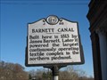 view gallery view galleryW7.1 km | Barnett Canal in North Carolina Historical Markers Located in Rockingham County .. Eden, NC
An unusual area where one man brought industry into a growing community. posted by: GeoGordie location: North Carolina date approved: 03/27/2006 last visited: 12/26/2018 |
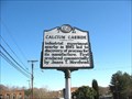 view gallery view galleryW7.1 km | Calcium Carbide in North Carolina Historical Markers Located in Rockingham County .. Eden, NC
West Meadow Road posted by: GeoGordie location: North Carolina date approved: 03/15/2006 last visited: 12/26/2018 |
 view gallery view gallery SW7.6 km SW7.6 km
| Lower Saura Town in North Carolina Historical Markers Located in Rockingham County .. Eden, NC
Near the Dan River on NC 14 posted by: GeoGordie location: North Carolina date approved: 03/09/2006 last visited: 12/26/2018 |
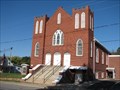
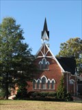 view gallery view galleryW7.9 km |  First Baptist Church - Eden, North Carolina First Baptist Church - Eden, North Carolina
in U.S. National Register of Historic Places The First Baptist Church is located in Eden, North Carolina. posted by:  Sneakin Deacon Sneakin Deacon location: North Carolina date approved: 11/08/2007 last visited: 06/04/2012 |
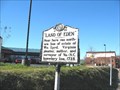 view gallery view gallerySW7.9 km | Land Of Eden in North Carolina Historical Markers Located in Rockingham County .. Eden, NC
An area that would in time be called Leaksville - Draper - Spray, North Carolina. Then take on the name of Eden, North Carolina posted by: GeoGordie location: North Carolina date approved: 03/27/2006 last visited: 12/26/2018 |
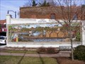 view gallery view gallerySW8 km |  Dan River "Rivermen" Mural- Eden, NC Dan River "Rivermen" Mural- Eden, NC
in Murals New mural in Eden NC posted by: erikwillke location: North Carolina date approved: 04/06/2009 last visited: 06/20/2013 |
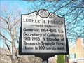 view gallery view gallerySW8.2 km | Luther H. Hodges in North Carolina Historical Markers Located in Rockingham County .. near Eden, NC.
On South Hamilton St. ( Hwy 87 ) posted by: GeoGordie location: North Carolina date approved: 03/10/2006 last visited: 12/27/2018 |
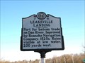 view gallery view gallerySW8.2 km | Leaksville Landing in North Carolina Historical Markers Located in Rockingham County .. Eden, North Carolina.
A once thriving area of commerce and general trade along the Dan River. posted by: GeoGordie location: North Carolina date approved: 03/27/2006 last visited: 12/26/2018 |
 view gallery view galleryW8.2 km | Mt. Sinai Baptist Church - Eden, North Carolina in U.S. National Register of Historic Places Mt. Siani Baptist Church is located in Eden, North Carolina posted by: Sneakin Deacon location: North Carolina date approved: 11/08/2007 last visited: 06/04/2012 |
 view gallery view gallerySW8.2 km |  Dan River - Vital Supply Line - Confederate Lifeline - Eden, NC, USA Dan River - Vital Supply Line - Confederate Lifeline - Eden, NC, USA
in Civil War Discovery Trail Sites The marker gives a lesson on the importance of the Dan River to the war effort in North Carolina. The bateaux transported coal and other goods to assist troops in the area. posted by: NCDaywalker location: North Carolina date approved: 12/30/2018 last visited: 02/22/2019 |
 view gallery view gallery NE8.4 km NE8.4 km
|  Gravity Hill - Pittsylvania County, Virginia Gravity Hill - Pittsylvania County, Virginia
in Vortexes, Mystery Spots, and Gravity Hills A magnetic, or gravity hill going "up" Oak Hill Road posted by: 3newsomes location: Virginia date approved: 03/20/2009 last visited: 11/03/2016 |
 view gallery view galleryW8.5 km |  William Byrd "Land of Eden" Boundary Marker William Byrd "Land of Eden" Boundary Marker
in Public Land Survey Marks The Southwest corner of the 20,000-acre estate of William Byrd is here at this stone. He was a Virginia planter, author, and surveyor of Va.-N.C. line in 1728. This marker is in a residential area of Eden, NC. posted by: NCDaywalker location: North Carolina date approved: 12/28/2018 last visited: 02/22/2019 |
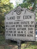 view gallery view galleryW8.5 km | Land of Eden in North Carolina Historical Markers This historic marker is located on South Hamilton Street in the City of Eden, North Carolina. posted by: Sneakin Deacon location: North Carolina date approved: 11/07/2007 last visited: 12/26/2018 |
 view gallery view galleryW8.7 km | Charlie Poole in North Carolina Historical Markers Located in Rockingham County .. Eden, NC
Highway 14 posted by: GeoGordie location: North Carolina date approved: 03/15/2006 last visited: 12/26/2018 |
 view gallery view galleryW11.4 km |  Virginia / North Carolina - RT 87 Moorehead Ave Virginia / North Carolina - RT 87 Moorehead Ave
in Border Crossings Single lane state road leading from Virginia to North Carolina posted by: nomadwillie location: Virginia date approved: 11/13/2016 last visited: never |
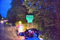
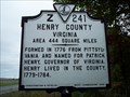 view gallery view galleryW11.6 km |  Henry County / North Carolina Henry County / North Carolina
in Virginia Historical Markers Located on Hwy. 87 just north of the NC/VA line posted by: 3newsomes location: Virginia date approved: 10/16/2009 last visited: 10/05/2009 |
 view gallery view gallery SE14.8 km SE14.8 km
| O.P. Fitzgerald | J-47 in North Carolina Historical Markers Located on NC 87 at US 29 in Reidsville posted by: slnewsome location: North Carolina date approved: 04/15/2008 last visited: 02/27/2008 |
 view gallery view gallery S15.4 km S15.4 km
| Chinqua-Penn Plantation - Reidsville, NC in U.S. National Register of Historic Places Located near Reidsville - featured on "American Castles" on the A&E Channel and listed on the National Register of Historic Places posted by: 3newsomes location: North Carolina date approved: 02/11/2009 last visited: 06/04/2012 |
 view gallery view galleryS15.4 km |  Chinqua Penn Plantation - Rockingham Co., NC Chinqua Penn Plantation - Rockingham Co., NC
in Official Local Tourism Attractions Located near Reidsville - featured on "American Castles" on the A&E Channel and listed on the National Register of Historic Places posted by: 3newsomes location: North Carolina date approved: 02/12/2009 last visited: 06/04/2012 |
 view gallery view gallerySW15.4 km |  Meridian Marker - Rockingham County, NC Meridian Marker - Rockingham County, NC
in U.S. Historic Survey Stones and Monuments The station was used to determine magnetic declination as part of a statewide magnetic survey posted by: CurtJohnson location: North Carolina date approved: 10/11/2011 last visited: never |
 view gallery view gallerySW15.6 km | Wright Tavern (J-26) in North Carolina Historical Markers Rare example of dog-run building. posted by: slnewsome location: North Carolina date approved: 02/09/2008 last visited: 06/04/2012 |
 view gallery view gallery N15.8 km N15.8 km
|  Axton, VA 24054 Axton, VA 24054
in U.S. Post Offices Axton, VA 24054. posted by: SportsPhotoGuy location: Virginia date approved: 06/13/2010 last visited: 04/13/2012 |
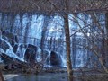 view gallery view gallery NW16.4 km NW16.4 km
|  Fisher Dam - Ridgeway, VA Fisher Dam - Ridgeway, VA
in Water Dams A hidden dam with nice cascade falls located off a trail starting at the Smith River Trails - Marrowbone Canoe Launch posted by: 3newsomes location: Virginia date approved: 01/08/2009 last visited: 01/01/2009 |
 view gallery view gallerySE16.7 km |  Castle of Horror Castle of Horror
in Haunted Attractions Indoor haunted attraction, seasonal. Almost all costumes are constructed by the proprietor. 15 minutes. posted by: Ranger Fox location: North Carolina date approved: 10/31/2007 last visited: never |
|