 view gallery view gallery S9.3 km S9.3 km
|   Defeated Creek Recreation Area Boat Ramp - Defeated Creek, TN Defeated Creek Recreation Area Boat Ramp - Defeated Creek, TN
in Boat Ramps Exit 258 off I-40, north on Hwy 53 to Hwy 25, right on Hwy. 80, right on Hwy. 85, 4 miles to park posted by:  mr.volkswagen mr.volkswagen location: Tennessee date approved: 08/26/2010 last visited: 10/23/2011 |
 view gallery view galleryS10.3 km | Cordell Hull Lake Boat Ramp in Boat Ramps Located just off Hull Rd. posted by: mr.volkswagen location: Tennessee date approved: 12/17/2010 last visited: never |
 view gallery view gallery SW10.9 km SW10.9 km
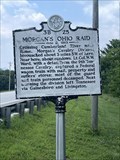
|  Morgan's Ohio Raid 3B 25 - Riddleton, TN Morgan's Ohio Raid 3B 25 - Riddleton, TN
in Tennessee Historical Markers A Tennessee Historical Commission marker on Dixon Springs Hwy (Hwy 25) in Riddleton about Morgan's Ohio Raid. posted by: Team Geologynut location: Tennessee date approved: 06/28/2023 last visited: never |
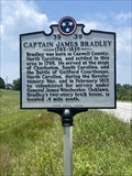 view gallery view gallerySW10.9 km | Captain James Bradley 3B 39 - Dixon Springs, TN in Tennessee Historical Markers A Tennessee Historical Commission marker on Dixon Springs Hwy (Hwy 25) in Dixon Springs about Captain James Bradley. posted by: Team Geologynut location: Tennessee date approved: 06/28/2023 last visited: never |
 view gallery view gallery NW13.2 km NW13.2 km
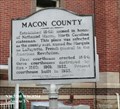
|  Ambush at Meadorville-Conflict in Macon County - Lafayette TN Ambush at Meadorville-Conflict in Macon County - Lafayette TN
in U.S. Civil War Sites In the spring of 1863, a Confederate partisan band established itself in this part of the county, where it harassed Federal units and threatened local Unionists. posted by:  Don.Morfe Don.Morfe location: Tennessee date approved: 05/28/2023 last visited: 05/28/2023 |
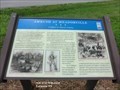 view gallery view galleryNW13.2 km |  Ambush at Meadorville-Conflict in Macon County - Lafayette TN Ambush at Meadorville-Conflict in Macon County - Lafayette TN
in Battlefields This rural hamlet experienced a serious firefight between Union cavalry and infantry and the Confederate irregulars on May 2, 1863. Confederate guerillas hidden in the brush of Goose Creek ambushed Union Cos. D and E, 11th Kentucky Infantry. posted by: Don.Morfe location: Tennessee date approved: 05/26/2023 last visited: 05/26/2023 |
 view gallery view galleryNW13.2 km | Ambush at Meadorville Conflict in Macon County - Lafayette TN in Civil War Discovery Trail Sites During the Civil War, Macon County experienced internal strife as did many other areas of Tennessee. posted by: Don.Morfe location: Tennessee date approved: 06/09/2020 last visited: 10/06/2021 |
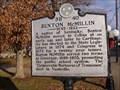 view gallery view galleryS16.1 km | Benton McMillin in Tennessee Historical Markers Life accomplishments of Benton McMillin. posted by: 8Nuts MotherGoose location: Tennessee date approved: 07/31/2010 last visited: 05/08/2023 |
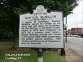 view gallery view galleryS16.1 km |  Benton McMillin - Cartage TN Benton McMillin - Cartage TN
in Citizen Memorials Benton McMillin was elected to the State Legislature in 1874 and Congress in 1879 for a twenty year tenure. Benton McMillin served two terms as Governor, 1899-1903. The “Democratic Warhorse of Tennessee” died in Nashville. posted by: Don.Morfe location: Tennessee date approved: 05/07/2023 last visited: 05/08/2023 |
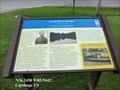
 view gallery view galleryS16.1 km |  Smith County Courthouse - Carthage Tennessee Smith County Courthouse - Carthage Tennessee
in Wikipedia Entries The courthouse is located on the Court Square in Carthage, a small town in Smith County, Tennessee, United States. It overlooks the Cumberland River. posted by: Don.Morfe location: Tennessee date approved: 11/09/2022 last visited: 11/10/2022 |
 view gallery view galleryS16.1 km | Smith County Courthouse Square-A Major Federal Base - Carthage TN in Civil War Discovery Trail Sites Carthage’s historic courthouse square was the control center of a major Federal base from 1863 to 1865 in the fight to control the Upper Cumberland River region. posted by: Don.Morfe location: Tennessee date approved: 05/09/2020 last visited: 10/08/2021 |
 view gallery view galleryS16.1 km |  Smith County Courthouse - Carthage TN Smith County Courthouse - Carthage TN
in Courthouses Carthage’s historic courthouse square was the control center of a major Federal base from 1863 to 1865 in the fight to control the Upper Cumberland River region. posted by: Don.Morfe location: Tennessee date approved: 11/17/2022 last visited: 11/10/2022 |
 view gallery view galleryS16.1 km | Smith County Courthouse Square-A Major Federal Base - Carthage TN in U.S. Civil War Sites Carthage’s historic courthouse square was the control center of a major Federal base from 1863 to 1865 in the fight to control the Upper Cumberland River region. posted by: Don.Morfe location: Tennessee date approved: 05/08/2023 last visited: 05/08/2023 |
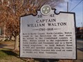 view gallery view galleryS16.1 km | Captain William Walton in Tennessee Historical Markers Captain William Walton - His accomplishments. posted by: 8Nuts MotherGoose location: Tennessee date approved: 07/31/2010 last visited: 05/08/2023 |
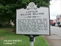 view gallery view galleryS16.1 km | Captain William Walton - Cartage TN in Citizen Memorials William Walton 1760-1816 settled in the Cumberland country in 1784. Walton served in the legislatures of North Carolina and Tennessee and as a Smith County magistrate. posted by: Don.Morfe location: Tennessee date approved: 05/07/2023 last visited: 05/08/2023 |
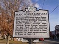 view gallery view galleryS16.1 km | Bragg Invades Kentucky in Tennessee Historical Markers Tale of a Civil War Battle. posted by: 8Nuts MotherGoose location: Tennessee date approved: 07/31/2010 last visited: 05/08/2023 |
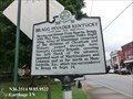 view gallery view galleryS16.1 km | Bragg Invades Kentucky - Carthage TN in Battlefields Bragg Invades Kentucky from Sept-Oct, 1862 Moving northwest from Sparta, Bragg, with Maj. Gen. Leonidas Polk’s Right Wing, Army of Mississippi. Forrest’s Cavalry Brigade surrendered in Munford, KY to Bragg on Sept. 14, 1862. posted by: Don.Morfe location: Tennessee date approved: 05/07/2023 last visited: 05/08/2023 |
 view gallery view galleryS16.3 km | Cordell Hull Memorial Bridge 3B 83 - Carthage, TN in Tennessee Historical Markers Cordell Hull Memorial Bridge. Good parking across the side street at the Quick & Easy Market. posted by: Team Geologynut location: Tennessee date approved: 01/12/2019 last visited: 04/10/2023 |
 view gallery view galleryNW16.3 km | Macon County Confederate Soldiers Monument - Lafayette TN in American Civil War Monuments and Memorials This monument dedicated in memory of the men who served in the Confederate States Army from Macon County, Tennessee during the war between the states 1861-1865. posted by: Don.Morfe location: Tennessee date approved: 05/27/2023 last visited: 05/27/2023 |
 view gallery view galleryNW16.4 km | Macon County - Lafayette TN in Tennessee Historical Markers Established 1842; named in honor of Nathaniel Macon, North Carolina statesman. This place was selected as the county seat, named for Marquis de LaFayette. posted by: Don.Morfe location: Tennessee date approved: 10/14/2020 last visited: 10/20/2021 |
 view gallery view galleryNW16.4 km | Macon County in the Civil War-Division and Conflict - Lafayette TN in Battlefields Three engagements took place in Macon County. On May 3, 1863, at Meadorville, four miles south of Lafayette on Highway 10, elements of two Federal units, the 11th Kentucky Infantry and 8th Kentucky Cavalry, fought Confederate guerrillas. posted by: Don.Morfe location: Tennessee date approved: 05/27/2023 last visited: 05/27/2023 |
 view gallery view galleryNW16.4 km | Macon County in the Civil War Division and Conflict - Lafayette TN in U.S. Civil War Sites During the Civil War, about 500 Macon County men served on each side. The Highland Rim ridge, as well as family loyalties, generally separated Confederates from Unionists. posted by: Don.Morfe location: Tennessee date approved: 05/28/2023 last visited: 05/28/2023 |
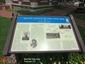
 view gallery view galleryNW16.4 km |  You Are Here Maps-Macon County in the Civil War-Division and Conflict - Lafayette TN You Are Here Maps-Macon County in the Civil War-Division and Conflict - Lafayette TN
in 'You Are Here' Maps The You Are Here map shows that you are at the courthouse lawn, 201 County Courthouse, Lafayette TN posted by: Don.Morfe location: Tennessee date approved: 05/27/2023 last visited: 05/27/2023 |
 view gallery view galleryNW16.4 km | Macon County in the Civil War-Division and Conflict - Lafayette TN in Civil War Discovery Trail Sites During the Civil War, about 500 Macon County men served on each side. The Highland Rim ridge, as well as family loyalties, generally separated Confederates from Unionists. posted by: Don.Morfe location: Tennessee date approved: 06/09/2020 last visited: 10/06/2021 |
 view gallery view galleryS16.7 km | Upper Ferry On the Cumberland River - Carthage TN in Civil War Discovery Trail Sites As a major Cumberland River port with three landings, Carthage was strategically important to both Confederate and Union forces. The Upper Ferry and landing was located near the present Corps of Engineer boat ramp near Upper Ferry Road. posted by: Don.Morfe location: Tennessee date approved: 05/09/2020 last visited: 10/08/2021 |
|