 view gallery view gallery NE8 km NE8 km
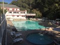
|   California Hot Springs Resort - California Hot Springs, CA California Hot Springs Resort - California Hot Springs, CA
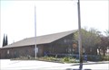
in Hot Springs The California Hot Springs Resort is located in the Central-Southern Sierra Nevada Mountains of California, just inside The Giant Sequoia National Monument and Forest . posted by:  DougK DougK location: California date approved: 09/04/2015 last visited: never |
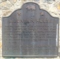
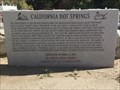 view gallery view galleryNE8 km |  California Hot Springs Marker - California Hot Springs, CA California Hot Springs Marker - California Hot Springs, CA
in E Clampus Vitus Historical Markers This marker is near the entrance to the California Hot Springs office. posted by: DougK location: California date approved: 09/11/2015 last visited: never |
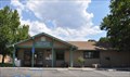
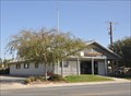
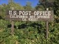 view gallery view galleryNE8.2 km |  California Hot Springs, CA - 93207 California Hot Springs, CA - 93207
in U.S. Post Offices This Post Office is located alongside road M-56 in the Sequoia National Forest. posted by: DougK location: California date approved: 09/04/2015 last visited: never |
 view gallery view gallery S12.6 km S12.6 km
|  Lavers Crossing Lavers Crossing
in California Historical Markers In 1854, John C. Reid filed a squatter's claim on this spot - the same year Kern County's first school class was held here. In 1859, David Lavers, with his father and brother, John, built a hotel and stage barn on the old Bull Road. posted by: elrojo14 location: California date approved: 08/11/2015 last visited: 07/18/2015 |
 view gallery view galleryS13.8 km | Glennville, California 93226 in U.S. Post Offices This Post Office is located at 10686 Highway 155 in Glennville, California. posted by: brwhiz location: California date approved: 02/03/2013 last visited: never |
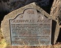 view gallery view galleryS14.2 km | Glennville Adobe in California Historical Markers Kern County's oldest residence. Built before Civil War by Thomas Fitzgerald as trading post at junction of two Indian trails. Present Greenhorn Road follows east - west trail (later McFarlane Toll Road) to Kern River mining districts. posted by: elrojo14 location: California date approved: 06/07/2015 last visited: 07/18/2015 |
 view gallery view gallery SW19.5 km SW19.5 km
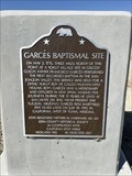
| GARCÉS BAPTISMAL SITE in California Historical Markers California State Historical Landmark No. 631 "Garcés Baptismal Site". posted by: elrojo14 location: California date approved: 10/07/2022 last visited: never |
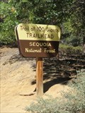 view gallery view galleryNE20 km |  Trail of 100 Giants - Sequoia National Monument, California Trail of 100 Giants - Sequoia National Monument, California
in Hiking and walking trailheads The Trail of 100 Giants is the most popular attraction in the Giant Sequoia National Monument, and it's easy to see why. The trail is easy to get to, it's short, flat, and paved, and it's got a lot of really impressive trees. posted by: DougK location: California date approved: 03/18/2016 last visited: never |
 view gallery view gallery SE21.2 km SE21.2 km
|  Greenhorn Summit Elev 6102 Ft Greenhorn Summit Elev 6102 Ft
in Elevation Signs Greenhorn Summit Elev 6102 Ft. Hwy 155, Kern County CA posted by:  michael3900 michael3900 location: California date approved: 09/17/2008 last visited: never |
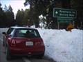
 view gallery view gallerySW25.3 km | Mountain House in California Historical Markers One and one-half miles north of this point stood the site of the Butterfield Stage Station known as Mountain House, operating through present Kern County during 1858-1861. This famous line ran from St. Louis, Missouri, to San Francisco. posted by: elrojo14 location: California date approved: 08/11/2015 last visited: never |
 view gallery view galleryNE27.4 km |  Johnsondale Bridge, Kern River, California You Are Here Sign Johnsondale Bridge, Kern River, California You Are Here Sign
in 'You Are Here' Maps Johnsondale Bridge, Kern River, California posted by: toponym location: California date approved: 05/26/2009 last visited: never |
 view gallery view gallery W27.5 km W27.5 km
| Ducor, California 93218 in U.S. Post Offices This Post Office is located at 23318 Avenue 56 in Ducor, California. posted by: brwhiz location: California date approved: 10/15/2013 last visited: never |
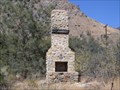 view gallery view gallery E27.8 km E27.8 km
|  Kernville Lonely Chimney Kernville Lonely Chimney
in Lonely Chimneys A lonely Chimney along the Kern River. posted by: toponym location: California date approved: 05/25/2009 last visited: never |
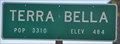
 view gallery view gallery NW29.6 km NW29.6 km
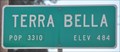
|  Terra Bella ~ Population 3,466 Terra Bella ~ Population 3,466
in Population Signs This combination Elevation/Population sign is on Road 236 at Avenue 96 at the northern city limits of Terra Bella. posted by: brwhiz location: California date approved: 10/12/2013 last visited: never |
 view gallery view galleryNW29.6 km | Terra Bella, California 93270 in U.S. Post Offices This Post Office is located at 9622 Road 236 in Terra Bella, California. posted by: brwhiz location: California date approved: 10/15/2013 last visited: never |
 view gallery view galleryNW29.6 km | Terra Bella ~ Elevation 484 in Elevation Signs This combination Elevation/Population sign is on Road 236 at Avenue 96 at the northern city limits of Terra Bella. posted by: brwhiz location: California date approved: 10/12/2013 last visited: never |
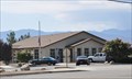
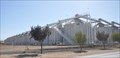 view gallery view galleryNW29.8 km |  Setton Farms Pistachio Elevators Setton Farms Pistachio Elevators
in Grain Elevators These large silos, used for storing pistachios, are located in Terra Bella, California. posted by: brwhiz location: California date approved: 11/04/2013 last visited: never |
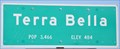 view gallery view galleryNW29.9 km | Terra Bella ~ Elevation 484 in Elevation Signs This combination Elevation/Population sign is on California Highway 65 (All American City Highway) at the southern city limits of Terra Bella. posted by: brwhiz location: California date approved: 10/12/2013 last visited: never |
 view gallery view galleryNW29.9 km | Terra Bella ~ Population 3,466 in Population Signs This combination Elevation/Population sign is on California Highway 65 (All American City Highway) at the southern city limits of Terra Bella. posted by: brwhiz location: California date approved: 10/12/2013 last visited: never |
 view gallery view galleryNW30.3 km | Terra Bella ~ Population 3,466 in Population Signs This combination Elevation/Population sign is on Avenue 95 at California Highway 65 (All American City Highway) at the western city limits of Terra Bella. posted by: brwhiz location: California date approved: 10/12/2013 last visited: never |
 view gallery view galleryNW30.3 km | Terra Bella ~ Elevation 484 in Elevation Signs This combination Elevation/Population sign is on Avenue 95 at California Highway 65 (All American City Highway) at the western city limits of Terra Bella. posted by: brwhiz location: California date approved: 10/12/2013 last visited: never |
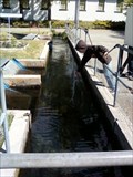 view gallery view galleryE30.3 km |  Kern River Fish Hatchery- Kernville, CA, USA Kern River Fish Hatchery- Kernville, CA, USA
in Fish Hatcheries Kern River Fish Hatchery, 14415 Sierra Way, Kernville, CA,
(760) 376-2846 posted by: calgriz location: California date approved: 09/06/2014 last visited: 01/02/2014 |
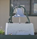 view gallery view galleryNW30.6 km |  Alta Vista School Bell Alta Vista School Bell
in Bells This Bell is on the grounds of the Alta Vista School in Porterville. posted by: brwhiz location: California date approved: 11/04/2013 last visited: never |
 view gallery view gallerySE30.7 km | Wofford Heights, California 93285 in U.S. Post Offices This Post Office is located at 6336 Wofford Blvd in Wofford Heights, California. posted by: brwhiz location: California date approved: 02/03/2013 last visited: 03/18/2014 |
 E30.9 km |  Kern Valley, CA - Geocaching Tips & Tours Kern Valley, CA - Geocaching Tips & Tours
in Geocaching Tour Guides Email us if you are going to be in this area and require any insider info or assistance. We are a middle aged British couple and know the area well. posted by: The Brits location: California date approved: 04/22/2006 last visited: never |
|