 view gallery view gallery W0 km W0 km
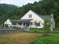
|   Barnardsville - Barnardsville, NC 28709 Barnardsville - Barnardsville, NC 28709
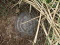
in U.S. Post Offices Near the end of the road... posted by:  DnRseekers DnRseekers location: North Carolina date approved: 08/15/2013 last visited: 08/09/2013 |
 view gallery view gallery SW9.3 km SW9.3 km
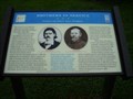
|  Brothers In Service - Zebulon and Robert Vance Brithplace - Weaverville - NC Brothers In Service - Zebulon and Robert Vance Brithplace - Weaverville - NC
in Civil War Discovery Trail Sites Marker is near Weaverville, North Carolina, in Buncombe County. Marker is on Reems Creek Road (State Road 1003), on the right when traveling north. posted by:  Countrydragon Countrydragon location: North Carolina date approved: 01/01/2010 last visited: 08/22/2013 |
 view gallery view gallery NW10 km NW10 km
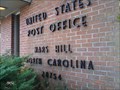
| Mars Hill, NC 28754 in U.S. Post Offices The Mars Hill, NC Post Office. posted by: papermanone & catlover location: North Carolina date approved: 01/02/2007 last visited: 01/02/2015 |
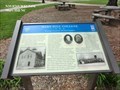 view gallery view galleryNW10.1 km | Mars Hill College-Strategic Location, Divided Loyalties - Mars Hill in U.S. Civil War Sites Confederate troops left Mars Hill to forage in March 1865. Col. George W. Kirk led his 3rd North Carolina Mounted Infantry (U.S.) into the village and burned the college dormitory and teachers' residence. posted by: Don.Morfe location: North Carolina date approved: 04/20/2023 last visited: 04/20/2023 |
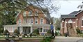 view gallery view galleryNW10.1 km |  Mars Hill University - Mars Hill NC Mars Hill University - Mars Hill NC
in Universities and Colleges Mars Hill University was founded as the French Broad Baptist Institute in Madison County in 1856, in the days leading up to the Civil War. Shortly thereafter, the name was changed to Mars Hill College. posted by: Don.Morfe location: North Carolina date approved: 04/20/2023 last visited: 04/20/2023 |
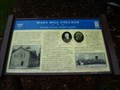 view gallery view galleryNW10.1 km | Mars Hill College Strategic Location, Divided Loyalties - Mars Hill in Madison County, North Carolina in Civil War Discovery Trail Sites Marker is in Mars Hill, North Carolina, in Madison County. posted by: Countrydragon location: North Carolina date approved: 01/01/2010 last visited: 04/20/2023 |
 view gallery view galleryNW10.1 km |  Mars Hill College-Strategic Location, Divided Loyalties - Mars Hill Mars Hill College-Strategic Location, Divided Loyalties - Mars Hill
in Battlefields Confederate troops left Mars Hill to forage in March 1865. Col. George W. Kirk led his 3rd North Carolina Mounted Infantry (U.S.) into the village and burned the college dormitory and teachers' residence. posted by: Don.Morfe location: North Carolina date approved: 04/21/2023 last visited: 04/20/2023 |
 view gallery view gallery SE11.1 km SE11.1 km
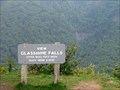
|  GLASSMINE FALLS. Blue Ridge Parkway (NC) GLASSMINE FALLS. Blue Ridge Parkway (NC)
in Scenic Roadside Look-Outs Scenic Overlook, with view of 800-foot high Glassmine Falls. posted by: PFF location: North Carolina date approved: 08/27/2009 last visited: 05/16/2023 |
 view gallery view gallery S12.2 km S12.2 km
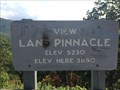
|  Lane Pinnacle - Asheville, NC - 3890 feet Lane Pinnacle - Asheville, NC - 3890 feet
in Elevation Signs Lane Pinnacle - Asheville, NC - 3890 feet posted by: CuriousBM location: North Carolina date approved: 10/10/2016 last visited: 06/10/2018 |
 view gallery view galleryS12.2 km |  LANE PINNACLE LANE PINNACLE
in U.S. Benchmarks Horizontal Control Disk, placed at an overlook on the Blue Ridge Parkway in 2004. posted by: PFF location: North Carolina date approved: 08/25/2009 last visited: never |
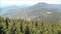
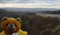 view gallery view galleryNW12.4 km | Buckner Gap - I-26W - NC in Scenic Roadside Look-Outs A view of the Black Mountains, including Mt. Mitchell, from Interstate 26 pull-off. posted by: vhasler location: North Carolina date approved: 03/29/2013 last visited: 05/28/2017 |
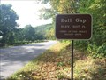 view gallery view galleryS12.7 km | Bull Gap - Asheville, NC - 3107 feet in Elevation Signs Bull Gap - Asheville, NC - 3107 feet posted by: CuriousBM location: North Carolina date approved: 10/10/2016 last visited: 06/10/2018 |
 view gallery view gallerySW12.9 km |  Subway -- Weaverville, NC Subway -- Weaverville, NC
in Subway Restaurants The Weaverville, NC Subway. posted by: papermanone & catlover location: North Carolina date approved: 01/02/2007 last visited: never |
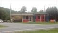
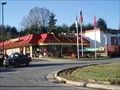 view gallery view gallerySW13.2 km |  Weaverville, NC McDonalds Weaverville, NC McDonalds
in McDonald's Restaurants Weaverville, NC McDonalds posted by: papermanone & catlover location: North Carolina date approved: 11/19/2006 last visited: 02/10/2021 |
 view gallery view galleryNW13.4 km |  I-26 Eastbound Lane - NC Welcome Center I-26 Eastbound Lane - NC Welcome Center
in Highway Rest Areas 7 miles east of TN/NC is a relatively new North Carolina Welcome Center posted by: vhasler location: North Carolina date approved: 08/29/2010 last visited: 04/02/2021 |
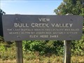 view gallery view galleryS13.5 km | Bull Creek Valley - Asheville, NC - 3483 feet in Elevation Signs Bull Creek Valley - Asheville, NC - 3483 feet posted by: CuriousBM location: North Carolina date approved: 10/10/2016 last visited: 06/27/2018 |
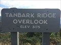 view gallery view galleryS14.2 km | Tanbark Ridge Overlook - Asheville, NC - 3175 feet in Elevation Signs Tanbark Ridge Overlook - Asheville, NC - 3175 feet posted by: CuriousBM location: North Carolina date approved: 10/10/2016 last visited: 08/27/2018 |
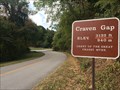 view gallery view galleryS14.8 km | Craven Gap - Asheville, NC - 3132 feet in Elevation Signs Craven Gap - Asheville, NC - 3132 feet posted by: CuriousBM location: North Carolina date approved: 10/10/2016 last visited: 06/10/2018 |
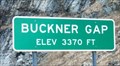 view gallery view galleryNW15.3 km |  Buckner Gap Buckner Gap
in Named Mountain Gaps Along I-26. Elevation 3370 feet. posted by: vhasler location: North Carolina date approved: 03/30/2013 last visited: 06/05/2018 |
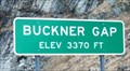 view gallery view galleryNW15.3 km | Buckner Gap - 3370 ft in Elevation Signs Along I-26 West (north) bound. posted by: vhasler location: North Carolina date approved: 03/29/2013 last visited: 05/05/2019 |
 view gallery view gallery E17.1 km E17.1 km
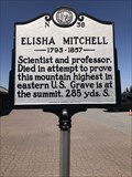
|  Elisha Mitchell N-38 Elisha Mitchell N-38
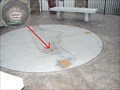
in North Carolina Historical Markers Located in the parking lot on top of Mount Mitchell. posted by: flyingmoose location: North Carolina date approved: 03/05/2023 last visited: 10/05/2023 |
 view gallery view galleryE17.2 km |  Mount Mitchell State Park - Mount Mitchell, North Carolina Mount Mitchell State Park - Mount Mitchell, North Carolina
in U.S. National Natural Landmarks Located just off of the Famous Blue Ridge Parkway, Mount Mitchell State Park provides visitors with breathtaking views of the Blue Ridge Mountains; historical insight into early American heritage and ample opportunities to commune with nature. posted by: PersonsMD location: North Carolina date approved: 05/24/2011 last visited: 10/04/2023 |
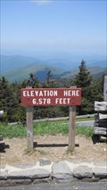 view gallery view galleryE17.2 km | Mount Mitchell Parking Lot, 6,578 Feet Mt. Mitchell, North Carolina in Elevation Signs A sign posting the elevation of the parking lot found near the summit of Mount Mitchell in North Carolina. Mount Mitchell is the highest peak in the United States found East of the Mississippi River. posted by: PersonsMD location: North Carolina date approved: 05/24/2011 last visited: 05/24/2017 |
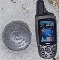 view gallery view galleryE17.2 km | Black Bear 2008 in U.S. Benchmarks The Black Beark Horizontal Control Mark can be found in the upper parking lot at the Mount Mitchell visitor center. posted by: PersonsMD location: North Carolina date approved: 05/26/2011 last visited: 08/27/2018 |
 view gallery view galleryE17.2 km | MOUNT MITCHELL (NC) in U.S. Benchmarks Special disk atop Mount Mitchell. posted by: PFF location: North Carolina date approved: 08/25/2009 last visited: 10/04/2023 |
|