 view gallery view gallery E3.7 km E3.7 km
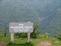
|   GLASSMINE FALLS. Blue Ridge Parkway (NC) GLASSMINE FALLS. Blue Ridge Parkway (NC)
in Scenic Roadside Look-Outs Scenic Overlook, with view of 800-foot high Glassmine Falls. posted by:  PFF PFF location: North Carolina date approved: 08/27/2009 last visited: 05/16/2023 |
 view gallery view gallery SW8.4 km SW8.4 km
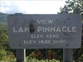
|  Lane Pinnacle - Asheville, NC - 3890 feet Lane Pinnacle - Asheville, NC - 3890 feet
in Elevation Signs Lane Pinnacle - Asheville, NC - 3890 feet posted by:  CuriousBM CuriousBM location: North Carolina date approved: 10/10/2016 last visited: 06/10/2018 |
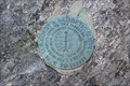
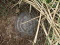 view gallery view gallerySW8.4 km |  LANE PINNACLE LANE PINNACLE
in U.S. Benchmarks Horizontal Control Disk, placed at an overlook on the Blue Ridge Parkway in 2004. posted by: PFF location: North Carolina date approved: 08/25/2009 last visited: never |
 view gallery view gallery NW8.5 km NW8.5 km
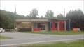
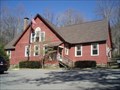
|  Barnardsville - Barnardsville, NC 28709 Barnardsville - Barnardsville, NC 28709
in U.S. Post Offices Near the end of the road... posted by: DnRseekers location: North Carolina date approved: 08/15/2013 last visited: 08/09/2013 |
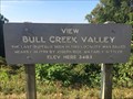 view gallery view gallerySW10.3 km | Bull Creek Valley - Asheville, NC - 3483 feet in Elevation Signs Bull Creek Valley - Asheville, NC - 3483 feet posted by: CuriousBM location: North Carolina date approved: 10/10/2016 last visited: 06/27/2018 |
 view gallery view gallery W10.5 km W10.5 km
|  Brothers In Service - Zebulon and Robert Vance Brithplace - Weaverville - NC Brothers In Service - Zebulon and Robert Vance Brithplace - Weaverville - NC
in Civil War Discovery Trail Sites Marker is near Weaverville, North Carolina, in Buncombe County. Marker is on Reems Creek Road (State Road 1003), on the right when traveling north. posted by: Countrydragon location: North Carolina date approved: 01/01/2010 last visited: 08/22/2013 |
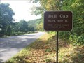 view gallery view gallerySW10.9 km | Bull Gap - Asheville, NC - 3107 feet in Elevation Signs Bull Gap - Asheville, NC - 3107 feet posted by: CuriousBM location: North Carolina date approved: 10/10/2016 last visited: 06/10/2018 |
 view gallery view galleryE11.6 km | MOUNT MITCHELL (NC) in U.S. Benchmarks Special disk atop Mount Mitchell. posted by: PFF location: North Carolina date approved: 08/25/2009 last visited: 10/04/2023 |
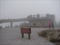 view gallery view galleryE11.6 km |  Mount Mitchell (NC) Observation Tower Mount Mitchell (NC) Observation Tower
in Look-Out Towers Observation platform built in 2009 to replace an aging stone structure with steep, narrow steps. Located on the highest point in the Eastern United States. posted by: PFF location: North Carolina date approved: 08/25/2009 last visited: 10/04/2023 |
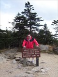
 view gallery view galleryE11.6 km |  HIGHEST - Mountain Peak East of the Mississippi River, Mt. Mitchell HIGHEST - Mountain Peak East of the Mississippi River, Mt. Mitchell
in Superlatives Mount Mitchell is the HIGHEST peak in the United Staets East of the Mississippi River. Standing at 6,684 feet and located in Mount Mitchell State Park just off of the Blue Ridge Parkway in North Carolina. posted by: PersonsMD location: North Carolina date approved: 05/24/2011 last visited: 10/04/2023 |
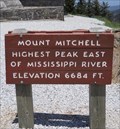
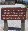 view gallery view galleryE11.6 km | Summit of Mount Mitchell - 6,684 Feet, Mt. Mitchell State Park, North Carolina in Elevation Signs Sign found at the summit of Mount Mitchell in Mount Mitchell State Park in North Carolina noting the elevation of 6,684 feet, the highest point in the United States East of the Mississippi River. posted by: PersonsMD location: North Carolina date approved: 05/24/2011 last visited: 10/04/2023 |
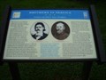
 view gallery view galleryE11.6 km |  Dr. Elisha Mitchell Dr. Elisha Mitchell
in Grave of a Famous Person Elisha Mitchell surveyed the highest peak east of the Mississippi River, Mt. Mitchell. posted by: ScubaDewd location: North Carolina date approved: 05/27/2006 last visited: 10/04/2023 |
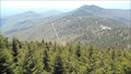
 view gallery view galleryE11.6 km |  Mt. Mitchell Mt. Mitchell
in Mountain Summits Mt. Mitchell, the highest peak east of the Mississippi River, is named for Dr. Elisha Mitchell, a professor of sciences at UNC-Chapel Hill who first suggested that the peak that bears his name was the highest in the Black Mountain range. Dr. Mitchell died at a waterfall on the western slope of the mountain while returning from one of many exploratory trips to western North Carolina. posted by: ScubaDewd location: North Carolina date approved: 04/03/2006 last visited: 10/04/2023 |
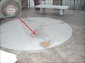
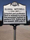 view gallery view galleryE11.6 km |  Elisha Mitchell N-38 Elisha Mitchell N-38
in North Carolina Historical Markers Located in the parking lot on top of Mount Mitchell. posted by: flyingmoose location: North Carolina date approved: 03/05/2023 last visited: 10/05/2023 |
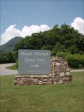
 view gallery view galleryE11.6 km |  Mount Mitchell State Park - Mount Mitchell, North Carolina Mount Mitchell State Park - Mount Mitchell, North Carolina
in U.S. National Natural Landmarks Located just off of the Famous Blue Ridge Parkway, Mount Mitchell State Park provides visitors with breathtaking views of the Blue Ridge Mountains; historical insight into early American heritage and ample opportunities to commune with nature. posted by: PersonsMD location: North Carolina date approved: 05/24/2011 last visited: 10/04/2023 |
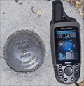 view gallery view galleryE11.6 km | Black Bear 2008 in U.S. Benchmarks The Black Beark Horizontal Control Mark can be found in the upper parking lot at the Mount Mitchell visitor center. posted by: PersonsMD location: North Carolina date approved: 05/26/2011 last visited: 08/27/2018 |
 view gallery view galleryE11.7 km | Mt. Mitchell, NC Geodetic in U.S. Benchmarks Geodetic Survey Benchmark found on the Basalm Nature Trail Near the Peak of Mount Mitchell, NC. posted by: JensenFamily05 location: North Carolina date approved: 10/23/2010 last visited: 08/12/2011 |
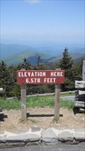 view gallery view galleryE11.7 km | Mount Mitchell Parking Lot, 6,578 Feet Mt. Mitchell, North Carolina in Elevation Signs A sign posting the elevation of the parking lot found near the summit of Mount Mitchell in North Carolina. Mount Mitchell is the highest peak in the United States found East of the Mississippi River. posted by: PersonsMD location: North Carolina date approved: 05/24/2011 last visited: 05/24/2017 |
 view gallery view galleryE11.7 km |  Mount Mitchell State Park - Burnsville, North Carolina Mount Mitchell State Park - Burnsville, North Carolina
in State/Provincial Parks The tallest mountain peak East of the Mississippi River is Mt. Mitchell, in North Carolina. posted by: BarbershopDru location: North Carolina date approved: 07/22/2010 last visited: 10/04/2023 |
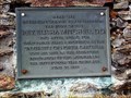
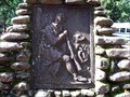
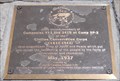 view gallery view galleryE11.7 km |  Camp SP-2 of the CCC, Mount Mitchell, North Carolina Camp SP-2 of the CCC, Mount Mitchell, North Carolina
in Civilian Conservation Corps A monument to the members of Companies 413 and 2410 at Camp SP-2 of the Civilian Conservation Corps located near the summit of Mount Mitchell, North Carolina. posted by: PersonsMD location: North Carolina date approved: 05/30/2011 last visited: 08/27/2018 |
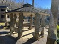 view gallery view gallery SE11.7 km SE11.7 km
|  Lake Susan Gazebo - Montreat, North Carolina Lake Susan Gazebo - Montreat, North Carolina
in Gazebos A gazebo located in Montreat, North Carolina. posted by: dream chaser location: North Carolina date approved: 12/17/2021 last visited: never |
 view gallery view gallerySE11.7 km | Montreat, NC 28757 in U.S. Post Offices The Montreat Post Office was originally a private residence. posted by: papermanone & catlover location: North Carolina date approved: 05/04/2007 last visited: 07/23/2014 |
 view gallery view gallerySE11.9 km |  Daniel Boone Marker # 68 - Montreat, NC Daniel Boone Marker # 68 - Montreat, NC
in Daniel Boone Trail Markers Daniel Boone Trail marker in a rock pyramid that was the base of an old flag pole. Parking lot of Anderson Auditorium, Montreat Conference Center grounds, Montreat, NC. Date placed approximately February 22, 1930. posted by: stanje1 location: North Carolina date approved: 01/16/2011 last visited: 08/29/2022 |
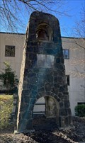 view gallery view gallerySE12.1 km |  Graham Chapel Bell - Black Mountain, North Carolina Graham Chapel Bell - Black Mountain, North Carolina
in Bell Towers A church bell located in Black Mountain, North Carolina. posted by: dream chaser location: North Carolina date approved: 04/06/2022 last visited: never |
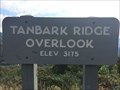 view gallery view gallerySW12.2 km | Tanbark Ridge Overlook - Asheville, NC - 3175 feet in Elevation Signs Tanbark Ridge Overlook - Asheville, NC - 3175 feet posted by: CuriousBM location: North Carolina date approved: 10/10/2016 last visited: 08/27/2018 |
|