 view gallery view gallery SW4.7 km SW4.7 km
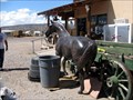
|   Collis the Salesman, San Ysidro NM Collis the Salesman, San Ysidro NM
in Fiberglass Horses I spotted this horse hanging out with some tubs, at a feed store in San Ysidro, New Mexico. posted by:  Queens Blessing Queens Blessing location: New Mexico date approved: 11/28/2011 last visited: 09/02/2013 |
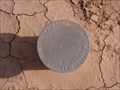 view gallery view gallerySW5.5 km |  Perea Nature Trail Survey Disk Perea Nature Trail Survey Disk
in U.S. Benchmarks Survey Disk along north side of Perea Nature Trail Trail. posted by: An1591 location: New Mexico date approved: 10/07/2011 last visited: 10/02/2011 |
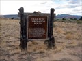
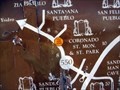
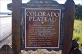 view gallery view gallerySW6.1 km |  Colorado Plateau Colorado Plateau
in New Mexico Historical Markers Colorado Plateau scenic historical marker along NM 550 west of San Ysidro. posted by: Aarky location: New Mexico date approved: 12/09/2010 last visited: 08/12/2022 |
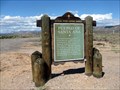
 view gallery view gallery S8.7 km S8.7 km
| Vasquez De Cornados Route, Socorro County, NM in New Mexico Historical Markers We noticed and photographed this sign while driving in Socorro County. posted by: Queens Blessing location: New Mexico date approved: 10/01/2011 last visited: 09/15/2012 |
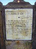 view gallery view galleryS10.9 km | Pueblo of Zia in New Mexico Historical Markers A New Mexico OSHM that really shows it's wear. posted by:  leadhiker leadhiker location: New Mexico date approved: 10/12/2011 last visited: never |
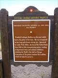 view gallery view galleryS10.9 km | Trinidad Gachupin Medina (ca. 1883-1964) in New Mexico Historical Markers A New Mexico Historic Women Marker on the Zia Pueblo - NM 550 at Milepost 18. posted by: leadhiker location: New Mexico date approved: 10/12/2011 last visited: never |
 view gallery view gallery N12.4 km N12.4 km
| Belen on the Camino Real, New Mexico in New Mexico Historical Markers The nearby town uses the name "Belen", which is explained by this sign. posted by: Queens Blessing location: New Mexico date approved: 11/19/2011 last visited: 07/24/2013 |
 view gallery view galleryN21.7 km |  Jemez State Ruins Jemez State Ruins
in Preserved Architectural Remnants and Ruins Jemez Ruins posted by: kingbee location: New Mexico date approved: 03/05/2009 last visited: 02/20/2016 |
 view gallery view gallery SE22.2 km SE22.2 km
|  Pueblo of Santa Ana near Bernalillo, New Mexico Pueblo of Santa Ana near Bernalillo, New Mexico
in 'You Are Here' Maps If you were to look at this stark, barren and desolate terrain, you may well ask yourself, WHERE AM I??? posted by: Queens Blessing location: New Mexico date approved: 10/09/2011 last visited: 09/02/2013 |
 view gallery view gallerySE22.2 km | Pueblo of Santa Ana, near Bernalillo, New Mexico in New Mexico Historical Markers This sign is located at the junction of Hwy 550 and Indian Service Route 74, north of Bernalillo. posted by: Queens Blessing location: New Mexico date approved: 10/07/2011 last visited: 09/15/2012 |
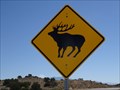 view gallery view gallerySE22.2 km |  Elk Crossing - Santa Ana Pueblo, NM Elk Crossing - Santa Ana Pueblo, NM
in Uncommon Crossing Signs An elk crossing sign stands on the west side of US 550, just across the road into the pueblo of Santa Ana, NM. posted by: QuarrellaDeVil location: New Mexico date approved: 10/23/2016 last visited: never |
 view gallery view galleryS27.8 km |  Mariposa - Rio Rancho, NM Mariposa - Rio Rancho, NM
in Abstract Public Sculptures An abstract sculpture of a butterfly at the entrance to the Mariposa Estates development; in Rio Rancho, New Mexico posted by: The Snowdog location: New Mexico date approved: 12/24/2019 last visited: never |
 view gallery view gallery NE27.8 km NE27.8 km
|  McCauley Natural Warm Spring McCauley Natural Warm Spring
in Hot Springs Half way between Jemez Falls Trailhead and Battleship Rock Picnic Grounds. posted by: RakeInTheCache location: New Mexico date approved: 11/04/2006 last visited: 05/28/2007 |
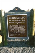 view gallery view gallerySE30.9 km | Bernalillo in New Mexico Historical Markers North suburbs of Albuquerque. posted by: YoSam. location: New Mexico date approved: 04/17/2009 last visited: 07/22/2011 |
 view gallery view gallerySE30.9 km |  Bernalillo, New Mexico - 5,050' Bernalillo, New Mexico - 5,050'
in Elevation Signs North suburbs of Albuquerque. posted by: YoSam. location: New Mexico date approved: 08/07/2016 last visited: never |
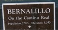 view gallery view gallerySE30.9 km |  Bernalillo, New Mexico - Population 2,763 Bernalillo, New Mexico - Population 2,763
in Population Signs North suburbs of Albuquerque. posted by: YoSam. location: New Mexico date approved: 08/07/2016 last visited: never |
 view gallery view gallerySE30.9 km | You Are Here ~ Bernalillo, NM in 'You Are Here' Maps That's right, "You Are Here" - you found the town, and it is just south of the sign. posted by: YoSam. location: New Mexico date approved: 04/18/2009 last visited: 09/13/2011 |
 view gallery view galleryS31.7 km |  Rio Rancho, NM Rio Rancho, NM
in City and Town Halls The city hall for Rio Rancho, NM. posted by: saopaulo1 location: New Mexico date approved: 12/14/2016 last visited: never |
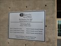 view gallery view galleryS31.7 km |  Rio Rancho City Hall - 2007 - Rio Rancho, NM Rio Rancho City Hall - 2007 - Rio Rancho, NM
in Dated Architectural Structures Multifarious City hall for Rio Rancho, NM. posted by: saopaulo1 location: New Mexico date approved: 12/14/2016 last visited: never |
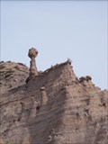 view gallery view gallery E31.7 km E31.7 km
|  Kasha-Katuwe Tent Rocks National Monument - New Mexico Kasha-Katuwe Tent Rocks National Monument - New Mexico
in Nature's Balanced Rocks There are multiple examples of balanced rocks in the Tent Rock National Monument area. posted by: GT.US location: New Mexico date approved: 03/07/2010 last visited: 05/26/2016 |
 view gallery view galleryE31.7 km |  Tent Rocks cave loop trail - Tent Rocks National Monument, New Mexico Tent Rocks cave loop trail - Tent Rocks National Monument, New Mexico
in Self Guided Walks and Trails The Cave Trail Loop in the Tent rocks is about 1.2 miles long with some altitude rise along the way. posted by: GT.US location: New Mexico date approved: 03/01/2010 last visited: 07/23/2009 |
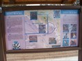
 view gallery view galleryE31.7 km |  Kasha-Katuwe Tent Rocks history - New Mexico Kasha-Katuwe Tent Rocks history - New Mexico
in Signs of History This sign was found on a trail that goes through the Kasha-Katuwe Tent Rocks National Monument. It tells the history of these formations. posted by: GT.US location: New Mexico date approved: 03/10/2010 last visited: 01/10/2011 |
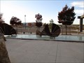 view gallery view galleryS31.9 km |  Sun Mask - Rio Rancho, NM Sun Mask - Rio Rancho, NM
in Artistic Seating A dish shaped seat outside of Rio Rancho City Hall. posted by: saopaulo1 location: New Mexico date approved: 12/14/2016 last visited: never |
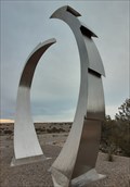
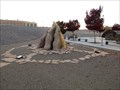 view gallery view galleryS31.9 km | Chaco Rising - Rio Rancho, NM in Abstract Public Sculptures Chaco Rising is an abstract piece in Rio Rancho, NM. posted by: saopaulo1 location: New Mexico date approved: 12/18/2016 last visited: never |
 view gallery view gallerySE32 km |  Bernalillo Water Tank - Bernalillo, NM Bernalillo Water Tank - Bernalillo, NM
in Water Towers A water tank in Bernalillo, NM. posted by: saopaulo1 location: New Mexico date approved: 12/12/2016 last visited: never |
|