 view gallery view gallery S24.3 km S24.3 km
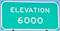
|   Interstate 40 Westbound ~ Elevation 6000 Feet Interstate 40 Westbound ~ Elevation 6000 Feet
in Elevation Signs This Elevation Sign is located just east of Interstate Highway 40, Exit 346 at the point where you are passing through the 6000 foot level just west of Houck, Arizona. posted by:  brwhiz brwhiz location: Arizona date approved: 09/07/2012 last visited: 06/07/2016 |
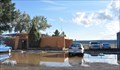
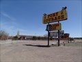 view gallery view galleryS24.8 km |  Fort Courage Trading Post - Houck, AZ Fort Courage Trading Post - Houck, AZ
in Route 66 - The Mother Road Abandoned kitschy trading post on Route 66 in Houck, Arizona posted by:  Wallyum Wallyum location: Arizona date approved: 05/24/2021 last visited: 04/15/2017 |
 view gallery view galleryS24.9 km | Querino Canyon Bridge - Route 66 - Apache County, Arizona, USA. in Route 66 - The Mother Road Querino Canyon Bridge a listed structure on the National Register of Historic Places - A deck truss bridge over Querino Canyon, that carried the 1930s to 1960s alignment of US-66 over the canyon between Houck, & Sanders in Arizona. posted by: veritas vita location: Arizona date approved: 02/25/2018 last visited: 03/02/2018 |
 view gallery view galleryS24.9 km |  Querino Canyon Bridge - Historic Route 66 - Apache County, Arizona, USA. Querino Canyon Bridge - Historic Route 66 - Apache County, Arizona, USA.
in Truss Bridges Querino Canyon Bridge a listed NRHP structure - A deck truss bridge over Querino Canyon, that carried the 1930s to 1960s alignment of US-66 over the canyon between Houck, & Sanders in Arizona. posted by: veritas vita location: Arizona date approved: 02/26/2018 last visited: 03/02/2018 |
 view gallery view galleryS24.9 km |  Querino Canyon Bridge - Houck, Apache County, Arizona, USA. Querino Canyon Bridge - Houck, Apache County, Arizona, USA.
in U.S. National Register of Historic Places Querino Canyon Bridge a listed structure on the National Register of Historic Places - A deck truss bridge over Querino Canyon, that carried the 1930s to 1960s alignment of US-66 over the canyon between Houck, & Sanders in Arizona. posted by: veritas vita location: Arizona date approved: 02/28/2018 last visited: 03/02/2018 |
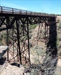 view gallery view galleryS24.9 km |  Historic Route 66 - Querino Canyon Bridge - Apache County, Arizona, USA. Historic Route 66 - Querino Canyon Bridge - Apache County, Arizona, USA.
in National Scenic Byways Querino Canyon Bridge a listed structure on the National Register of Historic Places - A deck truss bridge over Querino Canyon, that carried the 1930s to 1960s alignment of US-66 over the canyon between Houck, & Sanders in Arizona. posted by: veritas vita location: Arizona date approved: 02/26/2018 last visited: 03/02/2018 |
 view gallery view gallery SE26.6 km SE26.6 km
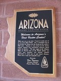
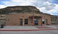
|  Arizona's FIRST Visitor Center Arizona's FIRST Visitor Center
in First of its Kind Located on I40, this was the first welcome center built in the state for the interstate system. posted by: ChapterhouseInc location: Arizona date approved: 10/31/2010 last visited: 09/30/2018 |
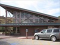 view gallery view gallerySE26.6 km |  Arizona Welcome Center - I40 Westbound Arizona Welcome Center - I40 Westbound
in Highway Rest Areas Located on I40, this was the first welcome center built in the state for the interstate system. posted by: ChapterhouseInc location: Arizona date approved: 11/02/2010 last visited: 10/31/2019 |
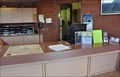 view gallery view gallerySE26.6 km |  Arizona Welcome Center Guest Book Arizona Welcome Center Guest Book
in Guest Books This Guest Book is inside the Arizona Welcome Center on Interstate Highway 40 at Exit 359 on the New Mexico/Arizona border. posted by: brwhiz location: Arizona date approved: 11/20/2012 last visited: 09/30/2018 |
 view gallery view gallerySE26.6 km |  One Days Ride to Zuni One Days Ride to Zuni
in Arizona Historical Markers A historic marker commemorating the bicentennial is erected at the welcome center. posted by: ChapterhouseInc location: Arizona date approved: 11/26/2010 last visited: 09/30/2018 |
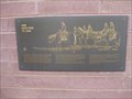 view gallery view gallerySE26.6 km |  One Days Ride to Zuni - Lupton, AZ One Days Ride to Zuni - Lupton, AZ
in Spirit of '76 A historic marker commemorating the bicentennial is erected at the welcome center. posted by: ChapterhouseInc location: Arizona date approved: 11/05/2010 last visited: 09/30/2018 |
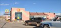
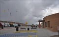
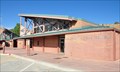 view gallery view gallerySE26.6 km |  Painted Cliffs Welcome Center ~ Lupton, Arizona Painted Cliffs Welcome Center ~ Lupton, Arizona
in Tourist Information Centers - Visitor Centers This Arizona Welcome Center is located in the Highway Rest Area on the north side of Interstate Highway 40 Exit 359 on the New Mexico/Arizona border. posted by: brwhiz location: Arizona date approved: 11/28/2012 last visited: 09/30/2018 |
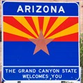 view gallery view gallerySE26.7 km |  Arizona ~ The Grand Canyon State Arizona ~ The Grand Canyon State
in Welcome Signs This Welcome Sign greets you on westbound Interstate Highway 40 shortly after you have crossed the border from New Mexico. posted by: brwhiz location: Arizona date approved: 11/20/2012 last visited: 10/31/2019 |
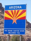 view gallery view gallerySE26.7 km | Welcome Sign - Arizona, USA. in Welcome Signs Arizona - The Grand Canyon State Welcomes You. - The Arizona Welcome Sign welcomes drivers heading West on Route 66, Photos taken from the Arizona welcome center parking lot on Historic Route 66. posted by: veritas vita location: Arizona date approved: 08/09/2014 last visited: 07/01/2021 |
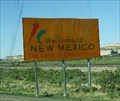 view gallery view gallerySE26.9 km | New Mexico, USA - The Land of Enchantment in Welcome Signs Welcome to New Mexico, Eastbound along I-10 posted by: Sun Chasers location: New Mexico date approved: 04/20/2012 last visited: 09/05/2018 |
 view gallery view gallerySE27 km |  Indian Rte. 12 - Lupton, AZ Indian Rte. 12 - Lupton, AZ
in Active Rail Locations Located just off Interstate 40, this spot offers an opportunity to watch trains pass the magnificent cliffs to the South. posted by: rjmcdonough1 location: Arizona date approved: 06/24/2021 last visited: never |
 view gallery view gallery NE28 km NE28 km
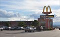
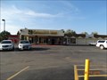
|  McDonalds ~ Window Rock, Arizona McDonalds ~ Window Rock, Arizona
in McDonald's Restaurants This McDonalds is located on State Highway 264 north of the airport in Window Rock, Arizona. posted by: brwhiz location: Arizona date approved: 12/01/2012 last visited: 07/29/2014 |
 view gallery view galleryNE28 km |  McDonalds Free WiFi ~ Window Rock, Arizona McDonalds Free WiFi ~ Window Rock, Arizona
in Wi-Fi Hotspots Free WiFi Served Daily at the McDonalds located on State Highway 264 north of the airport in Window Rock, Arizona. posted by: brwhiz location: Arizona date approved: 11/24/2012 last visited: never |
 view gallery view galleryNE28.2 km |  Window Rock Airport ~ Window Rock, Arizona Window Rock Airport ~ Window Rock, Arizona
in Airports This Airport, owned by the Navajo Nation, is located at the southwest end of Beacon Road, about one mile south of central Window Rock, Arizona. posted by: brwhiz location: Arizona date approved: 02/15/2013 last visited: never |
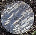 view gallery view galleryNE28.2 km |  Navajo Nation Control ~ FD9001 Navajo Nation Control ~ FD9001
in U.S. Benchmarks This Control Station is located near the Window Rock Airport terminal building at the southwest end of Beacon Road, about one mile south of central Window Rock, Arizona. posted by: brwhiz location: Arizona date approved: 02/15/2013 last visited: never |
 view gallery view gallery E28.3 km E28.3 km
| Manuelito Visitor Center in Tourist Information Centers - Visitor Centers This Tourist Information Center, operated by the New Mexico Department of Transportation, is located on the south side of Interstate Highway 40 just east of the Arizona/New Mexico border. posted by: brwhiz location: New Mexico date approved: 06/30/2013 last visited: 09/19/2015 |
 view gallery view galleryE28.3 km | Manuelito Rest Area in Highway Rest Areas This Highway Rest Area is located on the south side of Interstate Highway 40 about 3 miles east of the Arizona/New Mexico border. posted by: brwhiz location: New Mexico date approved: 07/02/2013 last visited: 09/19/2015 |
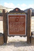 view gallery view gallerySE28.3 km |  Manuelito Area Manuelito Area
in New Mexico Historical Markers Located in the eastbound rest area near Manuelito posted by: Markerman62 location: New Mexico date approved: 10/15/2015 last visited: 11/08/2015 |
 view gallery view galleryNE28.6 km | Quality Inn - free wifi - Window Rock, AZ in Wi-Fi Hotspots Quality Inn - Highway 264, Window Rock, Arizona 86515 posted by: walkingwildly location: Arizona date approved: 08/21/2015 last visited: 10/31/2015 |
 view gallery view galleryNE29 km |  Navajo Nation Museum Penny Smasher Navajo Nation Museum Penny Smasher
in Penny Smashers This three-design Penny Smasher is in the Navajo Nation Museum at Highway 264 & Window Rock Loop Road in Window Rock, Arizona. posted by: brwhiz location: Arizona date approved: 10/16/2011 last visited: never |
|