 view gallery view gallery SW7.2 km SW7.2 km
|   Fontana Crossing, Fontana Dam, North Carolina Fontana Crossing, Fontana Dam, North Carolina
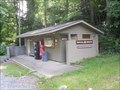
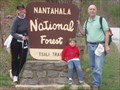
in Appalachian Trail Fontana Crossing is located on the Appalachian Trail and is near Fontana Dam and the town of Fontana Village Resort. Yes a bathroom, coke machine and telephone! posted by:  PersonsMD PersonsMD location: North Carolina date approved: 09/18/2009 last visited: 09/13/2009 |
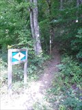 view gallery view gallerySW7.2 km | AT Trail Head at Fontana Crossing, North Carolina in Appalachian Trail An AT trail head at Fontana Crossing near Fontana Village, North Carolina and the Fontana Dam. posted by: PersonsMD location: North Carolina date approved: 09/18/2009 last visited: 08/21/2010 |
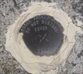
 view gallery view gallery W7.2 km W7.2 km
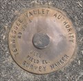
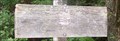
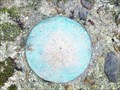
|  TVA Survey Marker 38-4, Fontana Dam, North Carolina TVA Survey Marker 38-4, Fontana Dam, North Carolina
in U.S. Benchmarks A Tennessee Valley Authority Survey Marker located between the two dam spillway over flow funnels for Fontana dam in North Carolina. posted by: PersonsMD location: North Carolina date approved: 09/20/2009 last visited: 08/13/2009 |
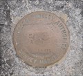
 view gallery view galleryW7.2 km | TVA Survey Marker 34-1, Fontana Dam, North Carolina in U.S. Benchmarks A Tennessee Valley Authority Survey Marker located on the road over the Fontana Dam in North Carolina posted by: PersonsMD location: North Carolina date approved: 09/17/2009 last visited: 08/21/2010 |
 view gallery view galleryW7.2 km | TVA Survey Marker 33-2R, Fontana Dam, North Carolina in U.S. Benchmarks A Tennessee Valley Authority Survey Mark located in the roadbed that crosses the crest of the Fontana Dam in North Carolina. posted by: PersonsMD location: North Carolina date approved: 09/17/2009 last visited: 07/09/2011 |
 view gallery view galleryW7.2 km | TVA Survey Marker, 32-2, Fontana Dam, North Carolina in U.S. Benchmarks Located on the roadbed of the Tennessee Valley Authority Fontana Dam in North Carolina. posted by: PersonsMD location: North Carolina date approved: 09/17/2009 last visited: 07/09/2011 |
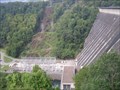 view gallery view galleryW7.4 km |  Fontana Dam Fontana Dam
in Wikipedia Entries The Highest dam in the TVA system,and highest concrete dam East of the Rocky Mountains. Completed in 1944 it is 480 feet high and 2,385 feet across. Creates Fontana Lake with 10,230 acres of water surface.
posted by: PersonsMD location: North Carolina date approved: 09/16/2009 last visited: 02/04/2017 |
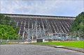
 view gallery view galleryW7.4 km |  Fontana Dam, Fontana Village, North Carolina Fontana Dam, Fontana Village, North Carolina
in Water Dams The Highest dam in the TVA system,and highest concrete dam East of the Rocky Mountains. Completed in 1944 it is 480 feet high and 2,385 feet across. Creates Fontana Lake with 10,230 acres of water surface. posted by: PersonsMD location: North Carolina date approved: 09/16/2009 last visited: 02/04/2017 |
 view gallery view galleryW7.6 km |  Fontana Dam - Robbinsville NC Fontana Dam - Robbinsville NC
in Hydroelectric Power Stations Fontana Dam is a hydroelectric dam on the Little Tennessee River in Swain and Graham counties, North Carolina, United States. posted by: nomadwillie location: North Carolina date approved: 11/03/2013 last visited: 06/24/2022 |
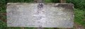
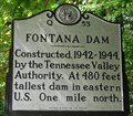 view gallery view gallerySW7.6 km |  Fontana Dam ~ Q 53 Fontana Dam ~ Q 53
in North Carolina Historical Markers A marker noting the construction of the Fontana Dam, located on highway 28 near Fontana Village, North Carolina. posted by: PersonsMD location: North Carolina date approved: 09/19/2009 last visited: 02/04/2017 |
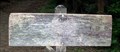
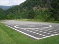 view gallery view galleryW8.5 km |  TVA Fontana Dam Landing Pad, Fontana Villiage, North Carolina TVA Fontana Dam Landing Pad, Fontana Villiage, North Carolina
in Helicopter Landing Pads A landing pad located at the outflow of the Fontana Dam in North Carolina. Located in the Great Smokey Mountain National Park on the Little Tennessee River. posted by: PersonsMD location: North Carolina date approved: 09/14/2009 last visited: 09/13/2009 |
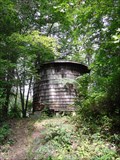 view gallery view gallerySW8.5 km |  Old Woodie H2O Tower, Fontana Village, North Carolina Old Woodie H2O Tower, Fontana Village, North Carolina
in Water Towers An old wodden water tower still in use near the Fontana TVA Dam. posted by: PersonsMD location: North Carolina date approved: 09/15/2009 last visited: 09/13/2009 |
 view gallery view gallery N10.1 km N10.1 km
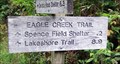
|  Eagle Creek Trail at the Appalachian Trail - Great Smoky Mountains National Park, TN Eagle Creek Trail at the Appalachian Trail - Great Smoky Mountains National Park, TN
in Hiking and walking trailheads The Eagle Creek Trail connects the Appalachian Trail to the Lakeshore Trail. posted by: hummerstation location: Tennessee date approved: 09/27/2015 last visited: never |
 view gallery view galleryN10.1 km | Bote Mountain Trail at the Appalachian Trail -Great Smoky Mountains National Park, TN in Hiking and walking trailheads The Bote Mountain Trail provides a one-trail access from Laurel Creek Road (the road into Cades Cove) to the Appalachian Trail. posted by: hummerstation location: Tennessee date approved: 11/04/2015 last visited: never |
 view gallery view galleryN12.1 km | Anthony Creek Trail at Bote Mountain Trail - Great Smoky Mountains National Park, TN in Hiking and walking trailheads The Anthony Creek Trail provides access to the Appalachian Trail from the Cades Cove area. posted by: hummerstation location: Tennessee date approved: 09/29/2015 last visited: never |
 view gallery view galleryN13.7 km | Lead Cove Trail at Bote Mountain Trail - Great Smoky Mountains National Park, TN in Hiking and walking trailheads The Lead Cove Trail provides a shorter route from Laurel Creek Road to the Appalachian Trail than the Bote Mountain Trail. posted by: hummerstation location: Tennessee date approved: 11/09/2015 last visited: never |
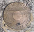
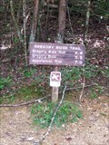
 view gallery view gallery NW13.7 km NW13.7 km
| Gregory Bald Elevation Benchmark - Great Smoky Mountains National Park, TN in U.S. Benchmarks Elevation benchmark on Gregory's Bald in the Great Smoky Mountains National Park, TN. posted by: hummerstation location: Tennessee date approved: 10/21/2013 last visited: 06/29/2014 |
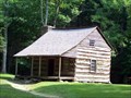 view gallery view galleryNW14.5 km |  Carter Shields Cabin - Great Smoky Mountains National Park, TN Carter Shields Cabin - Great Smoky Mountains National Park, TN
in Homesteads Log cabin built in 1880 in Cades Cove in what became the Great Smoky Mountains National Park. posted by: hummerstation location: Tennessee date approved: 06/27/2012 last visited: 06/21/2018 |
 view gallery view galleryN14.6 km | P I No. 68R - Great Smoky Mountains National Park, TN in U.S. Benchmarks Bronze disk in set in the top of a concrete base. posted by: hummerstation location: Tennessee date approved: 09/11/2012 last visited: never |
 view gallery view galleryNW14.6 km | Gregory Ridge Trail - Forge Creek Road end - Great Smoky Mountains National Park, TN in Hiking and walking trailheads Forge Creek Road trailhead of the Gregory Ridge Trail to Gregory Bald posted by: hummerstation location: Tennessee date approved: 09/11/2012 last visited: never |
 view gallery view gallery SE14.6 km SE14.6 km
|  Tsali Recreational Area Tsali Recreational Area
in Mountain Bike Trailheads Probably the most popular features of Tsali Recreation Area are the 39 miles of trails suited for mountain bikers and horse-back riders, as well as hikers. The 4-loop system offers a variety of landscapes. You can climb 1-foot wide rugged paths or travel flat, well-beaten roads meander through mixed pine and hardwoods on a peninsula stretching into Fontana Lake.
posted by: Ditchdoc531 location: North Carolina date approved: 09/08/2005 last visited: never |
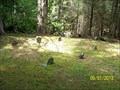
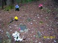 view gallery view galleryNW14.8 km |  Post Family Cemetery - Great Smoky Mountains National Park, TN Post Family Cemetery - Great Smoky Mountains National Park, TN
in Worldwide Cemeteries Small, family cemetery in a remote area of Cades Cove. posted by: hummerstation location: Tennessee date approved: 09/10/2012 last visited: never |
 view gallery view galleryNW14.8 km | Boring Family Cemetery - Great Smoky Mountains National Park, TN in Worldwide Cemeteries Small family cemetery located on a trail off Parson Branch Road in the Cades Cove area. posted by: hummerstation location: Tennessee date approved: 09/10/2012 last visited: never |
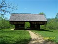 view gallery view galleryNW14.8 km |  Cantilever Barn - Cades Cove, Great Smoky Mountains National Park, TN Cantilever Barn - Cades Cove, Great Smoky Mountains National Park, TN
in Barns Cantilever barn at the Tipton Place on the Cades Cove Loop Road in the Great Smoky Mountains National Park. posted by: hummerstation location: Tennessee date approved: 05/18/2010 last visited: 06/20/2015 |
 view gallery view galleryNW14.8 km |  LeQuire Family Cemetery - Cades Cove, Great Smoky Mountains, TN LeQuire Family Cemetery - Cades Cove, Great Smoky Mountains, TN
in Abandoned Cemeteries Abondoned cemetery in former hayfield on the Cades Cove Loop Road. posted by: hummerstation location: Tennessee date approved: 05/13/2010 last visited: 10/13/2014 |
|