 view gallery view gallery E1.4 km E1.4 km
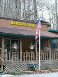
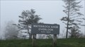
|   Moonshine Creek Campground Moonshine Creek Campground
in Campgrounds Great destination campground to explore the beatuy that is Western NC. posted by:  Capt Kirk Capt Kirk location: North Carolina date approved: 01/09/2006 last visited: 05/18/2011 |
 view gallery view gallery NE5 km NE5 km
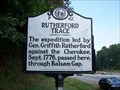
|  P 42 Rutherford Trace P 42 Rutherford Trace
in North Carolina Historical Markers 1776 Expedition against the Cherokee passed here posted by:  Padon Padon location: North Carolina date approved: 07/21/2008 last visited: 08/16/2021 |
 view gallery view galleryNE5.6 km |  Great Smoky Mountains Expressway Rest Area - NC Great Smoky Mountains Expressway Rest Area - NC
in Highway Rest Areas Serves both directions of the US 23. posted by:  ChapterhouseInc ChapterhouseInc location: North Carolina date approved: 07/16/2010 last visited: 09/30/2020 |
 view gallery view gallery NW6 km NW6 km
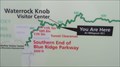
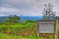
|  You Are Here - Waterrock Knob - Blue Ridge Mountains, North Carolina, USA. You Are Here - Waterrock Knob - Blue Ridge Mountains, North Carolina, USA.
in 'You Are Here' Maps Waterrock Knob the first Visitor center on the Blue Ridge Parkway as you drive North. An ideal spot for watching sunrise and sunsets across the Blue Ridge Mountains. posted by: veritas vita location: North Carolina date approved: 05/05/2015 last visited: 11/28/2022 |
 view gallery view galleryNW6 km |  Blue Ridge Parkway - Waterrock Knob - North Carolina, USA Blue Ridge Parkway - Waterrock Knob - North Carolina, USA
in National Scenic Byways Waterrock Knob the first Visitor center on the Blue Ridge Parkway as you drive North. The last trailhead before the Smokies, traveling South. An ideal spot for watching sunrise & sunsets across the Blue Ridge Mountains. Located at Milepost 451.2, posted by: veritas vita location: North Carolina date approved: 05/05/2015 last visited: 11/28/2022 |
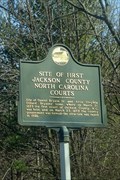 view gallery view gallery W6.8 km W6.8 km
| Site of First Jackson County North Carolina Courts in North Carolina Historical Markers On the Great Smoky Mountains Expressway (US 23/74) just east of Sylva. posted by: Markerman62 location: North Carolina date approved: 02/03/2015 last visited: 11/10/2018 |
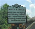 view gallery view galleryW8 km | INDIAN BOUNDARY - Q-32 - Sylva in North Carolina Historical Markers Survey line to hold back the white settlers - unsuccessfully. posted by: vhasler location: North Carolina date approved: 07/20/2013 last visited: 11/10/2018 |
 view gallery view gallery SW9.7 km SW9.7 km
|  McDonalds - Sylva, NC McDonalds - Sylva, NC
in Wi-Fi Hotspots Standard wifi service available - enjoyable with a small cone. posted by: vhasler location: North Carolina date approved: 07/21/2013 last visited: never |
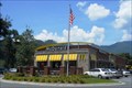 view gallery view gallerySW9.7 km |  McD's - Sylva, NC McD's - Sylva, NC
in McDonald's Restaurants New style McD's along Hwy US23 in Sylva. posted by: vhasler location: North Carolina date approved: 07/23/2013 last visited: 02/10/2021 |
 view gallery view gallery N10 km N10 km
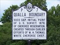
| P7 Qualla Boundary - Maggie Valley, NC in North Carolina Historical Markers Historical marker at the starting point of survey that created the Qualla Boundary, the official name for the Cherokee Indian Reservation in western North Carloina. posted by: hummerstation location: North Carolina date approved: 09/07/2012 last visited: 11/28/2022 |
 view gallery view galleryN10 km |  Initial Point Qualla Indian Boundary Survey - Maggie Valley, NC Initial Point Qualla Indian Boundary Survey - Maggie Valley, NC
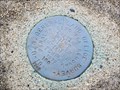
in U.S. Benchmarks Disk marking the initial point of the survey establishing the Qualla Boundary. posted by: hummerstation location: North Carolina date approved: 09/06/2012 last visited: 11/28/2022 |
 view gallery view galleryN10 km |  Initial Point Qualla Indian Boundary Survey - Maggie Valley, NC Initial Point Qualla Indian Boundary Survey - Maggie Valley, NC
in U.S. Historic Survey Stones and Monuments Disk marking the initial point of the survey establishing The Qualla Boundary. posted by: hummerstation location: North Carolina date approved: 09/08/2012 last visited: 11/28/2022 |
 view gallery view galleryNW10.3 km |  Soco Falls ~ Cherokee, North Carolina Soco Falls ~ Cherokee, North Carolina
in Waterfalls Soco Falls is a double waterfall located along Highway 19 close to the Blue Ridge Parkway. posted by: Manville Possum location: North Carolina date approved: 06/09/2015 last visited: 11/28/2022 |
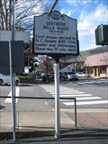
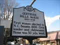 view gallery view gallerySW10.8 km | Gertrude Dills McKee (Q51) in North Carolina Historical Markers First woman elected to NC Senate (1930), held a residence in Sylva. posted by: ChapterhouseInc location: North Carolina date approved: 12/10/2006 last visited: 11/10/2018 |
 view gallery view gallerySW10.8 km |  The First Woman elected to the North Carolina Senate The First Woman elected to the North Carolina Senate
in First of its Kind First woman elected to NC Senate (1930), held a residence in Sylva. posted by: ChapterhouseInc location: North Carolina date approved: 12/10/2006 last visited: 11/10/2018 |
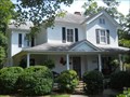
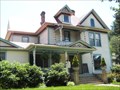 view gallery view gallerySW10.9 km |  Hooper, Dr. D. D., House - Sylva, NC Hooper, Dr. D. D., House - Sylva, NC
in U.S. National Register of Historic Places Queen Anne design house from turn of century... posted by: vhasler location: North Carolina date approved: 07/20/2013 last visited: never |
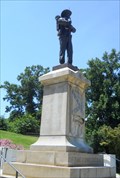 view gallery view galleryW11.1 km |  Jackson County Confederate Monument - Sylva, NC Jackson County Confederate Monument - Sylva, NC
in Smithsonian Art Inventory Sculptures On the steps leading to the courthouse... overlooking downtown. posted by: vhasler location: North Carolina date approved: 07/19/2013 last visited: 11/10/2018 |
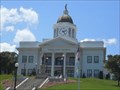 view gallery view galleryW11.1 km | Jackson County Courthouse - Sylva, NC in U.S. National Register of Historic Places High upon the hill... overlooking the town. Lots of steps up from Main Street. Expanded over the years to include the library. posted by: vhasler location: North Carolina date approved: 08/03/2013 last visited: 11/10/2018 |
 view gallery view galleryW11.1 km |  Sylva, NC Sylva, NC
in American Guide Series Sylva became the seat of Jackson County in 1913. Continues as a mountain town based on paper manufacturing and tourism. posted by: vhasler location: North Carolina date approved: 07/21/2013 last visited: 11/10/2018 |
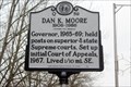 view gallery view galleryW11.3 km | Dan K. Moore 1906-1986 -Q 59 in North Carolina Historical Markers Located on W. Main St. (Bus US 23) in Mark Watson Park, Sylva posted by: Markerman62 location: North Carolina date approved: 01/09/2019 last visited: 12/30/2018 |
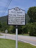 view gallery view galleryNE11.9 km | Plott Hound in North Carolina Historical Markers A marker commemorating the state of North Carolina. Located on SR 1173 (Plott Creek Road) at US 23 southwest of Waynesville. posted by: TheGeoGnomes location: North Carolina date approved: 08/18/2011 last visited: 08/30/2022 |
 view gallery view gallerySW11.9 km | Hedden, Elisha Calor, House - Webster, NC in U.S. National Register of Historic Places The two-story white Queen Anne style weatherboard home is the largest from the historical hey-day of Webster. posted by: vhasler location: North Carolina date approved: 07/21/2013 last visited: never |
 view gallery view galleryN11.9 km |  Fantasy Golf at Maggie Valley, NC Fantasy Golf at Maggie Valley, NC
in Miniature Golf Waterfalls, lighthouse, caves, boat, tunnels await you and your putter! posted by: TheGeoGnomes location: North Carolina date approved: 08/08/2010 last visited: 09/30/2020 |
 view gallery view galleryNW12.1 km |  Plott Balsam - Blue Ridge Parkway - Maggie Valley NC Plott Balsam - Blue Ridge Parkway - Maggie Valley NC
in Scenic Roadside Look-Outs Turnout with marker for some info on the Plott Balsams Mountain range on the Blue Ridge Parkway. posted by: nomadwillie location: North Carolina date approved: 11/08/2013 last visited: 06/10/2018 |
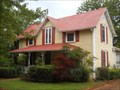 view gallery view gallerySW12.1 km | Moore, Walter E., House - Webster, NC in U.S. National Register of Historic Places A one and half story weatherboard home painted yellow was built by hometown lawyer in 1886. posted by: vhasler location: North Carolina date approved: 07/21/2013 last visited: never |
|