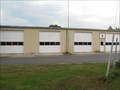
 view gallery view gallery NE2.3 km NE2.3 km
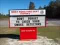
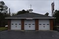
|   West Hoke Fire Dept Station 5 West Hoke Fire Dept Station 5
in Firehouses Well equipped rural volunteer fire department in the western reaches of Hoke County, North Carolina. They enjoy a fine relationship with their district supporters. posted by:  NCDaywalker NCDaywalker location: North Carolina date approved: 01/28/2016 last visited: 01/28/2016 |
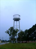
 view gallery view gallery N4.5 km N4.5 km
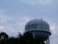
|  Hoke County Water System Elevated Tank Hoke County Water System Elevated Tank
in Water Towers This is part of a water system that serves the County of Hoke in Southeastern North Carolina. posted by: NCDaywalker location: North Carolina date approved: 09/28/2014 last visited: 09/28/2014 |
 view gallery view gallery S6 km S6 km
|  Boat Ramp - Lumber River NC Wildlife Commission Boat Ramp, near Wagram, NC Boat Ramp - Lumber River NC Wildlife Commission Boat Ramp, near Wagram, NC
in Boat Ramps NC Wildlife Commission boat launch, off US 401 South near Wagram, NC is just over the Scotland County line in Hoke County. The day of this visit things were rather quiet. Weekends are a different matter with lots of small boat to launch here to fish. posted by: NCDaywalker location: North Carolina date approved: 08/14/2009 last visited: 06/23/2010 |
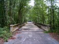 view gallery view galleryS6.1 km |  Old US 401 Gilchrist Bridge Old US 401 Gilchrist Bridge
in Orphaned Bridges Bridges over Old US 401 in Hoke and Scotland Counties over the Lumber river. posted by: NCDaywalker location: North Carolina date approved: 07/21/2009 last visited: 06/20/2010 |
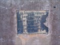 view gallery view galleryS6.1 km |  Old US 401 Gilchrist Bridge - 1922- Wagram, NC Old US 401 Gilchrist Bridge - 1922- Wagram, NC
in Bridge Date Stones and Plaques Bridges over Old US 401 in Hoke and Scotland Counties over the Lumber river. A favorite fishing spot amongst locals. posted by: NCDaywalker location: North Carolina date approved: 01/26/2011 last visited: 01/26/2011 |
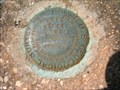 view gallery view galleryS6.1 km |  43 WSM 1949 224 - Benchmark 43 WSM 1949 224 - Benchmark
in U.S. Benchmarks This is a benchmark I found while investigating a few I had found without PID's. It is located in the NW abutment to the US 401 bridge crossing Drowning Creek/Lumber River north of Wagram, NC. posted by: NCDaywalker location: North Carolina date approved: 06/30/2010 last visited: 03/18/2018 |
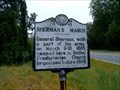 view gallery view gallery E6.3 km E6.3 km
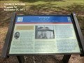
|  Sherman's March I-45, Bethel Church, Hoke Co, NC Sherman's March I-45, Bethel Church, Hoke Co, NC
in North Carolina Historical Markers Sherman and his army camped at Bethel Church in 1865. posted by: NCDaywalker location: North Carolina date approved: 08/24/2009 last visited: 08/23/2009 |
 view gallery view galleryS7.7 km | Wagram Village Water Tower - Wagram, NC in Water Towers Wagram's water tower is located one block off Main Street behind town hall. posted by: NCDaywalker location: North Carolina date approved: 08/23/2009 last visited: 06/20/2010 |
 view gallery view galleryS7.7 km | North Scotland Vol. Fire Dept. Wagram, NC in Firehouses The North Scotland Fire Department was formed from the Village of Wagram Fire Department in the late 70's when Scotland County government formed new fire districts for county residents, posted by: NCDaywalker location: North Carolina date approved: 09/24/2014 last visited: 09/24/2014 |
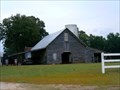 view gallery view galleryE7.9 km |  Barn - Wallace McLean Road, near Raeford, NC Barn - Wallace McLean Road, near Raeford, NC
in Barns Noticed this barn and area while looking for a place to turn around after photographing an old silo about a mile back further down the road. The old barn appears to be in use but not as active as it was once. posted by: NCDaywalker location: North Carolina date approved: 08/13/2009 last visited: 06/23/2010 |
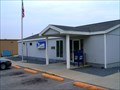 view gallery view galleryS8 km |  Wagram, NC 28396 Wagram, NC 28396
in U.S. Post Offices This is the new recently constructed post office located at 24100 North Main Street in Wagram, NC 28396-8939. posted by: NCDaywalker location: North Carolina date approved: 07/20/2009 last visited: 06/20/2010 |
 view gallery view galleryS8 km | GERALD JOHNSON 1890-1980 I-85 in North Carolina Historical Markers This historical marker is placed to celebrate journalist and author Gerald Johnson born in 1890 near here in the historic Riverton community approximately one mile east of the marker site. posted by: NCDaywalker location: North Carolina date approved: 07/20/2009 last visited: 08/29/2020 |
 view gallery view galleryS8 km | JOHN CHARLES McNEILL I-3 in North Carolina Historical Markers This is the historical marker located in Wagram, NC on US 401, south bound road side. It was placed to honor John Charles McNeill, a Poet Laureate of North Carolina, albeit an unofficial title at the time. He was awarded The Patterson Cup in 1905. posted by: NCDaywalker location: North Carolina date approved: 07/20/2009 last visited: 08/29/2020 |
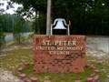 view gallery view gallery SW8.4 km SW8.4 km
|  Church Bell, St Peter's United Methodist Church, near Wagram, NC Church Bell, St Peter's United Methodist Church, near Wagram, NC
in Bells St Peter's United Methodist Church, near Wagram, NC has their church bell on the front of the church. posted by: NCDaywalker location: North Carolina date approved: 09/07/2009 last visited: 06/20/2010 |
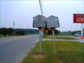
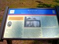
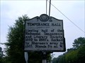 view gallery view gallerySW8.9 km | Temperance Hall I-48, Wagram, NC in North Carolina Historical Markers Temperance Hall historical marker is located on US 401 south in Wagram, NC. posted by: NCDaywalker location: North Carolina date approved: 08/10/2009 last visited: 08/29/2020 |
 view gallery view gallerySW8.9 km |  Wagram - Wagram NC Wagram - Wagram NC
in U.S. Civil War Sites This site lies along the route of Sherman’s army as it moved from Laurel Hill to Fayetteville. The Temperance Hall to your left was built in 1860. Passing troops allegedly shot off the upturned chalice (symbol of temperance) and Bible. posted by:  Don.Morfe Don.Morfe location: North Carolina date approved: 04/27/2023 last visited: 04/27/2023 |
 view gallery view gallerySW8.9 km |  Wagram-"Damnest marching I ever saw" — Sherman - Wagram - Wagram NC Wagram-"Damnest marching I ever saw" — Sherman - Wagram - Wagram NC
in Battlefields Confederate cavalrymen began reconnoitering the Federal advance before the Battle of Monroe’s Crossroads. A small skirmish occurred here as the Confederates intensified their reconnaissance. posted by: Don.Morfe location: North Carolina date approved: 04/27/2023 last visited: 04/27/2023 |
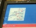 view gallery view gallerySW8.9 km |  You Are Here Maps-Wagram-"Damnest marching I ever saw" — Sherman - Wagram You Are Here Maps-Wagram-"Damnest marching I ever saw" — Sherman - Wagram
in 'You Are Here' Maps The You Are Here Map shows that you are on Spring Hill Road in Wagram NC. posted by: Don.Morfe location: North Carolina date approved: 04/26/2023 last visited: 04/27/2023 |
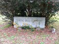
 view gallery view gallerySW8.9 km | Wagram - Civil War Discovery Trail Site in Civil War Discovery Trail Sites The marker for this waymark is in one of the most historic areas of Scotland County. On the same grounds where this marker is located are the home of John Charles McNeill and the Richmond Temperance Society. posted by: NCDaywalker location: North Carolina date approved: 09/01/2009 last visited: 08/29/2020 |
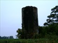 view gallery view galleryE9 km |  Wallace McLean Road - Raeford, NC Wallace McLean Road - Raeford, NC
in Solitary Silos I saw this silo while going over to Raeford, NC to do some geocaching and waymarking with my geocaching partner (wife) Shedazy. When I saw it standing all alone I knew I had to come back by on the way home. It is a concrete silo. posted by: NCDaywalker location: North Carolina date approved: 08/13/2009 last visited: 06/23/2010 |
 view gallery view gallerySW9 km |  John Charles McNeill, Wagram, NC John Charles McNeill, Wagram, NC
in Dead Poets' Society Memorials "John Charles McNeill (1874-1907), among North Carolina’s most important poets, enjoyed a short, yet successful, career as a journalist and a lawyer." posted by: NCDaywalker location: North Carolina date approved: 11/11/2015 last visited: 06/08/2005 |
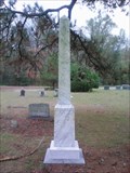
 view gallery view gallerySW9 km |  Spring Hill Cemetery, Wagram, NC, USA Spring Hill Cemetery, Wagram, NC, USA
in Worldwide Cemeteries Small historical cemetery off NC 144 near Wagram, NC. posted by: NCDaywalker location: North Carolina date approved: 11/11/2015 last visited: 11/12/2015 |
 view gallery view gallery W9.2 km W9.2 km
| Scotland County Water Tower, US 501 North - Wagram, NC in Water Towers Water tower located on US 501 N. It is part of the county water system overseen by the City of Laurinburg Public Works Department. posted by: NCDaywalker location: North Carolina date approved: 08/23/2009 last visited: 06/19/2010 |
 view gallery view galleryNE9.8 km | North Raeford Fire Dept 4 in Firehouses This Hoke County fire department serves an area that covers down to Scotland County line to just north of Raeford to the edge of Cumberland county. posted by: NCDaywalker location: North Carolina date approved: 04/07/2016 last visited: 04/07/2016 |
 view gallery view galleryW10 km |  Spring Hill Volunteer Fire Department Helipad, near Laurinburg, NC Spring Hill Volunteer Fire Department Helipad, near Laurinburg, NC
in Helicopter Landing Pads This helipad is at a local fire department in Scotland County about 9 miles north of Laurinburg, NC on US 501 North. posted by: NCDaywalker location: North Carolina date approved: 08/04/2014 last visited: 08/04/2014 |
|