 view gallery view gallery N34.8 km N34.8 km
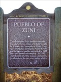
|   Pueblo of Zuni Pueblo of Zuni
in New Mexico Historical Markers This is a second OSHM for the Pueblo of Zuni. The other one is approx. 2.9 miles away at he east end of town. posted by:  leadhiker leadhiker location: New Mexico date approved: 06/11/2011 last visited: never |
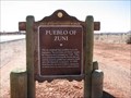 view gallery view gallery NE37.2 km NE37.2 km
| Pueblo of Zuni in New Mexico Historical Markers The Pueblo of Zuni, a place to step back in history, learn about a Native American culture or buy some fabulous Turquoise jewelery. posted by: linkys location: New Mexico date approved: 12/17/2009 last visited: 09/24/2010 |
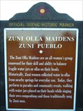 view gallery view galleryNE40.4 km | Zuni Olla Maidens - Zuni Pueblo in New Mexico Historical Markers A New Mexico Historic Women Marker. The New Mexico Historic Women Marker Initiative was founded in 2005 by members of the New Mexico Women's Forum in a statewide effort to recognize women's contributions to New Mexico history. posted by: leadhiker location: New Mexico date approved: 06/11/2011 last visited: never |
 view gallery view gallery SW46 km SW46 km
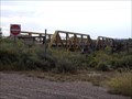
|  Pioneer Public Buildings - 194 Pioneer Public Buildings - 194
in D.U.P. Historic Markers If the bushes are grown you might miss this one. posted by: leadhiker location: Arizona date approved: 06/12/2011 last visited: never |
 view gallery view galleryNE55.8 km |  Zuni Reservation - New Mexico Zuni Reservation - New Mexico
in Nations Within Nations A traditional Pueblo People with a unique language, culture, and history that is famous for its inlayed silver jewelry, stone fetishes and pottery. posted by: linkys location: New Mexico date approved: 03/31/2008 last visited: 07/29/2014 |
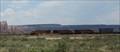
 view gallery view gallery NW58.9 km NW58.9 km
|  1923 Bridge over Rio Puerco in Sanders 1923 Bridge over Rio Puerco in Sanders
in Route 66 - The Mother Road This bridge was in operation from 1923 and carried the traffic of Route 66 over the Rio Puerco back in the day. posted by: TravisGood location: Arizona date approved: 01/13/2008 last visited: 10/31/2019 |
 view gallery view galleryNE59.7 km |  The Pioneer Gardener - Ramah, New Mexico The Pioneer Gardener - Ramah, New Mexico
in Figurative Public Sculpture Bronze life size sculpture a woman and child gardening. posted by: linkys location: New Mexico date approved: 04/01/2008 last visited: 05/10/2012 |
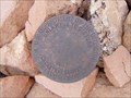 view gallery view galleryNE60.2 km |  Cadastral Disk in Ramah, NM Cadastral Disk in Ramah, NM
in U.S. Benchmarks Bureau of Land Management Cadastral Survey Disc on an exercise trail in the community of Ramah, New Mexico, USA posted by:  Hawikuh Hawikuh location: New Mexico date approved: 07/23/2009 last visited: never |
 view gallery view galleryNE60.2 km |  Ramah Water Tower - Ramah, New Mexico Ramah Water Tower - Ramah, New Mexico
in Water Towers Small water tower in a small New Mexico town. posted by: linkys location: New Mexico date approved: 03/31/2008 last visited: 07/28/2014 |
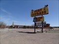 view gallery view galleryN60.8 km | Fort Courage Trading Post - Houck, AZ in Route 66 - The Mother Road Abandoned kitschy trading post on Route 66 in Houck, Arizona posted by: Wallyum location: Arizona date approved: 05/24/2021 last visited: 04/15/2017 |
 view gallery view galleryNE61 km |  Ramah Lake Dam - Ramah, New Mexico Ramah Lake Dam - Ramah, New Mexico
in Water Dams What started as an irrigation dike in the late 1890's is now an earthen dam on the Zuni River. posted by: linkys location: New Mexico date approved: 04/01/2008 last visited: never |
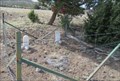 view gallery view gallery SE61.5 km SE61.5 km
|  Curtis Family Gravesite - Quemado NM Curtis Family Gravesite - Quemado NM
in Worldwide Cemeteries This very small cemetery is on the south side of US Hwy 60 about four miles west of Quemado, New Mexico. posted by: PeterNoG location: New Mexico date approved: 10/04/2017 last visited: 02/04/2017 |
 view gallery view galleryN61.6 km |  Interstate 40 Westbound ~ Elevation 6000 Feet Interstate 40 Westbound ~ Elevation 6000 Feet
in Elevation Signs This Elevation Sign is located just east of Interstate Highway 40, Exit 346 at the point where you are passing through the 6000 foot level just west of Houck, Arizona. posted by: brwhiz location: Arizona date approved: 09/07/2012 last visited: 06/07/2016 |
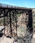 view gallery view galleryNW62.1 km |  Historic Route 66 - Querino Canyon Bridge - Apache County, Arizona, USA. Historic Route 66 - Querino Canyon Bridge - Apache County, Arizona, USA.
in National Scenic Byways Querino Canyon Bridge a listed structure on the National Register of Historic Places - A deck truss bridge over Querino Canyon, that carried the 1930s to 1960s alignment of US-66 over the canyon between Houck, & Sanders in Arizona. posted by: veritas vita location: Arizona date approved: 02/26/2018 last visited: 03/02/2018 |
 view gallery view galleryNW62.1 km | Querino Canyon Bridge - Route 66 - Apache County, Arizona, USA. in Route 66 - The Mother Road Querino Canyon Bridge a listed structure on the National Register of Historic Places - A deck truss bridge over Querino Canyon, that carried the 1930s to 1960s alignment of US-66 over the canyon between Houck, & Sanders in Arizona. posted by: veritas vita location: Arizona date approved: 02/25/2018 last visited: 03/02/2018 |
 view gallery view galleryNW62.1 km |  Querino Canyon Bridge - Houck, Apache County, Arizona, USA. Querino Canyon Bridge - Houck, Apache County, Arizona, USA.
in U.S. National Register of Historic Places Querino Canyon Bridge a listed structure on the National Register of Historic Places - A deck truss bridge over Querino Canyon, that carried the 1930s to 1960s alignment of US-66 over the canyon between Houck, & Sanders in Arizona. posted by: veritas vita location: Arizona date approved: 02/28/2018 last visited: 03/02/2018 |
 view gallery view galleryNW62.1 km |  Querino Canyon Bridge - Historic Route 66 - Apache County, Arizona, USA. Querino Canyon Bridge - Historic Route 66 - Apache County, Arizona, USA.
in Truss Bridges Querino Canyon Bridge a listed NRHP structure - A deck truss bridge over Querino Canyon, that carried the 1930s to 1960s alignment of US-66 over the canyon between Houck, & Sanders in Arizona. posted by: veritas vita location: Arizona date approved: 02/26/2018 last visited: 03/02/2018 |
 view gallery view galleryN63.6 km |  Indian Rte. 12 - Lupton, AZ Indian Rte. 12 - Lupton, AZ
in Active Rail Locations Located just off Interstate 40, this spot offers an opportunity to watch trains pass the magnificent cliffs to the South. posted by: rjmcdonough1 location: Arizona date approved: 06/24/2021 last visited: never |
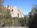
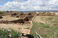 view gallery view galleryNE64.2 km |  Atsinna Pueblo ruins -- El Morro National Monument, NM Atsinna Pueblo ruins -- El Morro National Monument, NM
in New World Ancient Evidence The ruins of the Atsinna Pueblo at El Morro National Monument are located on top of the mesa, and are accessible from the Mesa Loop Trail posted by: Benchmark Blasterz location: New Mexico date approved: 08/25/2014 last visited: 01/18/2023 |
 view gallery view gallerySE64.4 km |  Quemado, NM Quemado, NM
in Wikipedia Entries Quemado is a census designated place in the mountains of western New Mexico. posted by: rjmcdonough1 location: New Mexico date approved: 08/26/2020 last visited: never |
 view gallery view gallerySE64.4 km |  Quemado NM pop 1,028 Quemado NM pop 1,028
in Population Signs This Population Sign is on US Hwy 60 on the west side of Quemado, New Mexico. posted by: PeterNoG location: New Mexico date approved: 04/06/2018 last visited: 08/18/2020 |
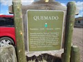 view gallery view gallerySE64.4 km | Quemado NM 6,890 ft in Elevation Signs This Elevation Sign is on US Hwy 60 on the west side of Quemado, New Mexico. posted by: PeterNoG location: New Mexico date approved: 03/16/2018 last visited: 08/18/2020 |
 view gallery view gallerySE64.4 km | Quemado, Quemado NM in New Mexico Historical Markers This New Mexico Historical Marker is on US Hwy 60 on the west side of Quemado, New Mexico. posted by: PeterNoG location: New Mexico date approved: 03/16/2018 last visited: 08/18/2020 |
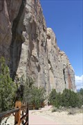 view gallery view galleryNE64.4 km |  Inscription Rock -- El Morro National Monument, NM Inscription Rock -- El Morro National Monument, NM
in Graffiti For thousands of years, human beings ranging from Ancient Puebloans to Spanish conquistadors to pioneers to railroad crews have been scratching their names into Inscription Rock. posted by: Benchmark Blasterz location: New Mexico date approved: 08/22/2014 last visited: 01/18/2023 |
 view gallery view galleryNE64.5 km |  Inscription Rock and Mesa Top Trail Loop - El Morro National Monument Inscription Rock and Mesa Top Trail Loop - El Morro National Monument
in Scenic Hikes One trail passes by the base and the other climbs to the top of El Morro, a 200 foot high questa that dominates El Morro National Monument. posted by: linkys location: New Mexico date approved: 04/04/2008 last visited: 01/18/2023 |
|