 view gallery view gallery W1.3 km W1.3 km
|   The Discovery Channel Telescope (DCT) The Discovery Channel Telescope (DCT)
in Astronomical Observatories The Discovery Channel Telescope (DCT)south east of Flagstaff. posted by:  Flag_Mtn_Hkrs Flag_Mtn_Hkrs location: Arizona date approved: 12/27/2005 last visited: 08/24/2020 |
 view gallery view gallery N19.5 km N19.5 km
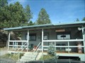
|  Mormon Lake, Arizona 86038 Mormon Lake, Arizona 86038
in U.S. Post Offices This Post Office is located at 1 Morman Lake Road in Mormon Lake, Arizona. posted by:  brwhiz brwhiz location: Arizona date approved: 09/05/2011 last visited: 08/24/2020 |
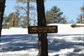
 view gallery view galleryN19.6 km |  Mormon Lake Village ~ Population 50 to 5000 Mormon Lake Village ~ Population 50 to 5000
in Population Signs This unusual Population Sign reflects the wild fluctuation in the number of inhabitants from winter to summer. posted by: brwhiz location: Arizona date approved: 06/23/2011 last visited: 04/27/2019 |
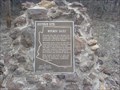 view gallery view galleryN24.5 km |  Mormon Dairy Mormon Dairy
in Arizona Historical Markers Mormon Dairy Arizona Historical Marker posted by: Flag_Mtn_Hkrs location: Arizona date approved: 03/31/2007 last visited: 04/27/2019 |
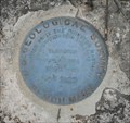
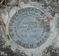 view gallery view gallery S25.7 km S25.7 km
|  USGS R41 1933 USGS R41 1933
in U.S. Benchmarks A USGS elevation benchmark between routes 87 and 141 on the Mogollon Rim in Arizona. posted by: dcrep location: Arizona date approved: 07/05/2009 last visited: never |
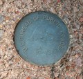
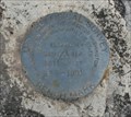 view gallery view galleryS26.2 km | USGS R55 1931 in U.S. Benchmarks A USGS elevation benchmark along route 87 near Pine, Arizona. posted by: dcrep location: Arizona date approved: 07/05/2009 last visited: never |
 view gallery view gallery SE26.4 km SE26.4 km
| USGS R43 1933 in U.S. Benchmarks A USGS elevation benchmark along Forest Road 141 on the Mogollon Rim in Arizona. posted by: dcrep location: Arizona date approved: 07/06/2009 last visited: 07/04/2011 |
 view gallery view galleryS26.4 km | USGS R42 1933 in U.S. Benchmarks A USGS elevation benchmark along Forest Road 141 on the Mogollon Rim in Arizona. posted by: dcrep location: Arizona date approved: 07/06/2009 last visited: never |
 view gallery view gallerySE29 km | USGS R44 1933 in U.S. Benchmarks A USGS elevation benchmark along Forest Road 141 on the Mogollon Rim in Arizona. posted by: dcrep location: Arizona date approved: 07/06/2009 last visited: never |
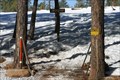
 view gallery view gallery NW29.1 km NW29.1 km
|  Munds Park/Mormon Lake Trail System - Munds Park, AZ Munds Park/Mormon Lake Trail System - Munds Park, AZ
in Offroad Trails This trail head is for the forest roads and network of ATV trails in the Coconino National Forest from Munds Park to Mormon Lake. There is a large parking area for trailers, and a kiosk with information on the 4x4, ATV, and Snowmobile trails. posted by: DopeyDuck location: Arizona date approved: 04/13/2009 last visited: 06/12/2012 |
 view gallery view galleryW29.5 km |  Ancient Graffiti, Lake Montezuma, AZ Ancient Graffiti, Lake Montezuma, AZ
in Graffiti Found some ancient graffiti at V-Bar V Site on Red Rock Pass. posted by: Poehunters location: Arizona date approved: 08/04/2013 last visited: 08/06/2021 |
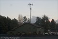 view gallery view galleryNW30.6 km |  Pinewood Fire Department - Munds Park, AZ Pinewood Fire Department - Munds Park, AZ
in Firehouses The Pinewood Fire Dept serves the Munds Park area along I-17 from Stoneman Lake to Kelly Canyon. The Pinewood Volunteer Association was formed in 1973, becoming a Special Fire District in 1976. posted by: DopeyDuck location: Arizona date approved: 04/10/2009 last visited: 05/18/2011 |
 view gallery view galleryNW30.6 km |  Pinewood Country Club - Munds Park, AZ Pinewood Country Club - Munds Park, AZ
in Public and Private Golf Courses The 18-hole Pinewood Golf Course and Country Club has a restaurant, lounge, driving range, pro shop, tennis courts, heated swimming pool, and many organized activities for members. posted by: DopeyDuck location: Arizona date approved: 04/14/2009 last visited: never |
 view gallery view galleryNW31.2 km | Munds Park, AZ 86017 in U.S. Post Offices Munds Park is a small town south of Flagstaff, AZ. This post office serves only PO Boxes. posted by: DopeyDuck location: Arizona date approved: 01/07/2009 last visited: 05/18/2011 |
 view gallery view galleryNW31.9 km | Janice Place ATV Trail - Munds Park, AZ in Offroad Trails This hiking & ATV trail in the Coconino National Forest is maintained by the volunteer Munds Park Trail Stewards (MUTS). There is a large pull-out for parking in front of the trailhead. posted by: DopeyDuck location: Arizona date approved: 01/20/2009 last visited: 06/12/2012 |
 view gallery view galleryNW31.9 km |  Munds Park Trail System - Janice Place Forest Access - Munds Park, AZ Munds Park Trail System - Janice Place Forest Access - Munds Park, AZ
in Hiking and walking trailheads This hiking & ATV trail in the Coconino National Forest is maintained by the volunteer Munds Park Trail Stewards (MUTS). There is a large pull-out for parking in front of the trailhead. posted by: DopeyDuck location: Arizona date approved: 01/20/2009 last visited: never |
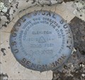
 view gallery view galleryS31.9 km | US Bureau of Public Roads 1955 in U.S. Benchmarks A US Bureau of Public Roads benchmark along route 87 north of Pine, Arizona. posted by: dcrep location: Arizona date approved: 07/06/2009 last visited: never |
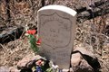 view gallery view galleryS32.3 km |  Andres Moreno Gravesite Andres Moreno Gravesite
in Out of Place Graves The solitary grave of Andres Moreno alongside Rim Road near Strawberry, AZ. posted by: dcrep location: Arizona date approved: 04/08/2009 last visited: 07/30/2013 |
 view gallery view galleryS32.5 km |  Mogollon Rim Fire Lookout Mogollon Rim Fire Lookout
in Look-Out Towers The Mogollon (MUGgy-own) Rim is a 200-mile long escarpment that marks the southern edge of the Colorado Plateau. The best views are from the fire lookout tower. posted by: TerryDad2 location: Arizona date approved: 10/04/2006 last visited: 07/23/2011 |
 view gallery view galleryW32.5 km |  Smokey Bear - Red Rock Visitor Center Coconino National Forest Smokey Bear - Red Rock Visitor Center Coconino National Forest
in Smokey Bear Sign Sightings Smokey Bear statue outside the Red Rock Visitor Center. posted by: NakoTacoPatrol location: Arizona date approved: 08/29/2013 last visited: 05/12/2014 |
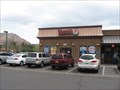 view gallery view galleryW32.5 km |  Wendy's - Route 179 - Sedona, AZ Wendy's - Route 179 - Sedona, AZ
in Wi-Fi Hotspots This Wendy's is next to the Subway in lower Sedona. posted by: bluesnote location: Arizona date approved: 02/22/2016 last visited: 02/22/2016 |
 view gallery view galleryW32.5 km |  Wendy's - Route 179 - Sedona, AZ Wendy's - Route 179 - Sedona, AZ
in Wendy's Restaurants This Wendy's is next to the Subway in lower Sedona. posted by: bluesnote location: Arizona date approved: 04/08/2011 last visited: 04/08/2011 |
 view gallery view galleryW32.7 km | Kokopelli Inn Free WiFi ~ Sedona, Arizona in Wi-Fi Hotspots Enjoy free WiFi internet access during your stay in the Kokopelli Inn at 6465 Highway 179 in Sedona, Arizona. posted by: brwhiz location: Arizona date approved: 10/11/2012 last visited: never |
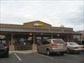 view gallery view galleryW32.7 km |  Subway - Hwy 179 - Sedona, AZ Subway - Hwy 179 - Sedona, AZ
in Subway Restaurants This subway is off of route 179 and next to the Wendy's. posted by: bluesnote location: Arizona date approved: 04/08/2011 last visited: 07/06/2015 |
 view gallery view galleryW32.7 km |  Kokopelli Inn ~ Sedona, Arizona Kokopelli Inn ~ Sedona, Arizona
in Kokopelli Sightings Kokopelli adorns the sign and the upper balcony railings at the Kokopelli Inn at 6465 Highway 179 in Sedona, Arizona. posted by: brwhiz location: Arizona date approved: 10/06/2012 last visited: never |
|