 view gallery view gallery S2.7 km S2.7 km
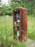
|   Vintage Gas Pump - Allsboro, Alabama Vintage Gas Pump - Allsboro, Alabama
in Vintage Gasoline Pumps A very deteriorated pump on the foundation of an old gas station. posted by:  Scrawlinn Scrawlinn location: Alabama date approved: 05/15/2008 last visited: 04/16/2013 |
 view gallery view galleryS3.9 km |  Natchez Trace near AL / MS State line. Natchez Trace near AL / MS State line.
in Ancient Traces and Roads Natchez Trace was believed to be started by bison traveling to salt licks. posted by: 8Nuts MotherGoose location: Mississippi date approved: 12/10/2007 last visited: 10/07/2013 |
 view gallery view galleryS3.9 km |  Natchez Trace Natchez Trace
in Wagon Roads and Trails Natchez Trace runs from Natchez, MS to Nashville, TN. posted by: 8Nuts MotherGoose location: Mississippi date approved: 06/13/2007 last visited: 10/07/2013 |
 view gallery view gallery N5.5 km N5.5 km
|  Mississippi on 72A Mississippi on 72A
in Border Crossings A scenic crossing in the hill country near the Natchez Trace. posted by: Scrawlinn location: Mississippi date approved: 05/19/2008 last visited: 08/03/2017 |
 view gallery view gallery NE8.2 km NE8.2 km
|  Shoe Tree - Hwy 72 - Alabama Shoe Tree - Hwy 72 - Alabama
in Shoe Trees This Shoe Tree is on the north side of U.S. Highway 72 about 4 miles west of Cherokee, Alabama and 4 miles west of the Mississippi border. posted by: PeterNoG location: Alabama date approved: 01/20/2012 last visited: 10/01/2016 |
 view gallery view galleryS8.2 km | AL-MS on Natchez Trace in Border Crossings This is at the border of Alabama and Mississippi on the Natchez Trace Parkway. posted by:  reg3 reg3 location: Alabama date approved: 09/08/2005 last visited: 08/03/2017 |
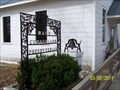 view gallery view galleryS8.4 km |  Maud Cumberland Presbyterian Church Bell - Maud, AL Maud Cumberland Presbyterian Church Bell - Maud, AL
in Bells Maud Cumberland Presbyterian Church Bell, Maud, AL posted by: hummerstation location: Alabama date approved: 03/09/2011 last visited: never |
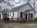 view gallery view galleryS8.4 km |  Maud Cumberland Presbyterian Church - Maud, AL Maud Cumberland Presbyterian Church - Maud, AL
in Presbyterian Churches Maud Cumberland Presbyterian Church, Maud, AL posted by: hummerstation location: Alabama date approved: 03/09/2011 last visited: never |
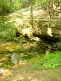 view gallery view galleryNE9.3 km |  Buzzard Roost Spring - Colbert County, AL Buzzard Roost Spring - Colbert County, AL
in Natural Springs Originally called Buzzard Sleep, changed to Buzzard Roost in 1801 by Levi Colbert, a renowned Chickasaw chieftain. The spring was a water source for the Colbert house which also served as an inn and stand for travelers on the Old Natchez Trace. posted by: Dulcimoore location: Alabama date approved: 07/25/2011 last visited: 10/01/2016 |
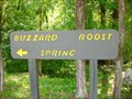 view gallery view galleryNE9.3 km |  Natchez Trace Parkway - Buzzard Roost Spring, near Cherokee, AL Natchez Trace Parkway - Buzzard Roost Spring, near Cherokee, AL
in National Scenic Byways Along the 33-mile stretch of the Natchez Trace Parkway in Alabama, just off US Hwy 72. Home place and site of Inn run by Chickasaw Chieftain Levi Colbert (1759-1834). posted by: Dulcimoore location: Alabama date approved: 07/24/2011 last visited: 10/01/2016 |
 view gallery view gallery NW11.1 km NW11.1 km
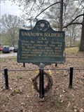
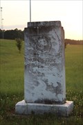
|  Unknown Soldiers (C.S.A) Unknown Soldiers (C.S.A)
in Mississippi Historical Markers Located within the CSA graves of Shady Grove Cemetery. posted by: flyingmoose location: Mississippi date approved: 05/04/2024 last visited: never |
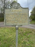 view gallery view galleryNW11.9 km | Eastport in Mississippi Historical Markers Located on the side of the road east of Iuka. posted by: flyingmoose location: Mississippi date approved: 05/04/2024 last visited: never |
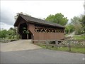 view gallery view galleryNW12.2 km |  Spring Creek Cover Bridge, Iuka, MS. Spring Creek Cover Bridge, Iuka, MS.
in Covered Bridges A beautiful old covered bridge in historic Iuka, Mississippi. posted by: the federation location: Mississippi date approved: 05/01/2013 last visited: 10/02/2016 |
 view gallery view galleryNW12.4 km |  Gov. John M. Stone Memorial Highway -- MS SH 25 at US 72, Iuka MS Gov. John M. Stone Memorial Highway -- MS SH 25 at US 72, Iuka MS
in Citizen Memorials A monument dedicates the MS State Highway 25 in MS the "Gov. John M. Stone Memorial Highway." His actions while Governor disenfranchised 90% of African-Americans in MS during the rise of Jim Crow in the American South, and spread across the region. posted by: Benchmark Blasterz location: Mississippi date approved: 10/28/2017 last visited: 08/03/2017 |
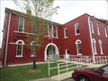
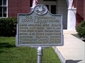 view gallery view galleryNW12.4 km |  Old Tishomingo County Courthouse, Iuka, MS. Old Tishomingo County Courthouse, Iuka, MS.
in Courthouses The former Tishimingo County County House has been preserved as the current Ishimingo County Historical Society. posted by: the federation location: Mississippi date approved: 08/30/2013 last visited: 10/01/2013 |
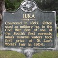 view gallery view galleryNW12.4 km | Iuka, Iuka, Tishomingo County, Mississippi in Mississippi Historical Markers Early look at Iuka. From Charter to world's fair. posted by: krsmith2 location: Mississippi date approved: 07/19/2013 last visited: 10/05/2013 |
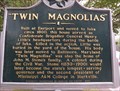 view gallery view galleryNW12.6 km | Twin Magnolias, Iuka, Tishomingo County, Mississippi in Mississippi Historical Markers The history of this house,and some of the people that lived there. posted by: krsmith2 location: Mississippi date approved: 07/19/2013 last visited: 10/05/2013 |
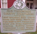 view gallery view galleryNW12.6 km | Old Tishomingo County Courthouse, Iuka, Tishomingo County, Mississippi in Mississippi Historical Markers History of the Courthouse. posted by: krsmith2 location: Mississippi date approved: 07/19/2013 last visited: 10/01/2013 |
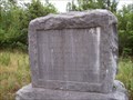
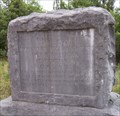
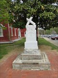 view gallery view galleryNW12.6 km |  Tishomingo County Confederate Memorial, Iuka, MS Tishomingo County Confederate Memorial, Iuka, MS
in American Civil War Monuments and Memorials A rather unusual Confederate marker located in Iuka, MS. posted by: the federation location: Mississippi date approved: 08/30/2013 last visited: 09/30/2013 |
 view gallery view galleryNW12.6 km |  Old Tishomingo County Courthouse History Museum, Iuka, MS Old Tishomingo County Courthouse History Museum, Iuka, MS
in History Museums A slice of the Old South found in a converted county courthouse. posted by: the federation location: Mississippi date approved: 08/30/2013 last visited: 10/01/2013 |
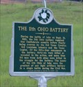
 view gallery view galleryNW12.6 km | The 11th Ohio Battery in Mississippi Historical Markers Located at the corner of MS-25 and Heritage Dr in Iuka, MS. This marker highlights the 11th Ohio Battery's actions, and losses during the Battle of Iuka. posted by: Mr. 0 location: Mississippi date approved: 03/23/2013 last visited: 08/03/2017 |
 view gallery view galleryNW12.6 km |  The 11th Ohio Battery -- Iuka MS The 11th Ohio Battery -- Iuka MS
in Specific Veteran Memorials A state historic marker located at the position of the 11th Ohio Battery, whose sustained more casualties during the Battle of Iuka than any other light artillery battery during the Civil War. posted by: Benchmark Blasterz location: Mississippi date approved: 10/30/2017 last visited: 08/03/2017 |
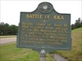
 view gallery view galleryNW12.6 km |  Battle of Iuka -- Iuka MS Battle of Iuka -- Iuka MS
in Battlefields The site of the Battle of Iuka, 19 Sep 1862, marked with a historical marker posted by: Benchmark Blasterz location: Mississippi date approved: 10/30/2017 last visited: 08/03/2017 |
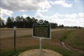
 view gallery view galleryNW12.6 km | Battle Of Iuka in Mississippi Historical Markers An easy to find sign just off of Route 72A; Marks the site of a Civil War battle. posted by: Scrawlinn location: Mississippi date approved: 05/15/2008 last visited: 08/03/2017 |
 view gallery view galleryNW12.6 km |  Battle of Iuka - US Civil War - Iuka MS USA Battle of Iuka - US Civil War - Iuka MS USA
in Political Revolutions The site of the US Civil War Battle of Iuka, Mississippi, which happened on 19 Sep 1862 posted by: Benchmark Blasterz location: Mississippi date approved: 11/02/2017 last visited: 08/04/2017 |
|