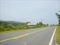
 view gallery view gallery SE8 km SE8 km
|   Rock City barn - RCB 01-25-03 Rock City barn - RCB 01-25-03
in Barns See Rock City barn in DeKalb County, AL posted by:  Wallyum Wallyum location: Alabama date approved: 04/10/2021 last visited: never |
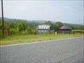 view gallery view gallerySE8.2 km | Rock City barn - RCB 01-25-04 in Barns See Rock City barn in DeKalb County, AL posted by: Wallyum location: Alabama date approved: 04/10/2021 last visited: never |
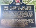 view gallery view gallery E8.4 km E8.4 km
|  The Church of the Nativity, Episcopal The Church of the Nativity, Episcopal
in Alabama Historical Markers A great example of Gothic Revival Design. posted by:  8Nuts MotherGoose 8Nuts MotherGoose location: Alabama date approved: 06/16/2007 last visited: never |
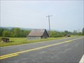 view gallery view gallerySE8.7 km | Rock City barn - RCB 01-25-02 in Barns See Rock City barn in DeKalb County, AL posted by: Wallyum location: Alabama date approved: 04/10/2021 last visited: never |
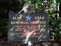 view gallery view galleryE10 km |  Alabama Welcome Center - I-59 Southbound at AL State Line - near Sulphur Springs, AL Alabama Welcome Center - I-59 Southbound at AL State Line - near Sulphur Springs, AL
in Blue Star Memorial Highway Markers Blue Star Marker at the I-59 Southbound Alabama Welcome Center at AL State Line posted by: hummerstation location: Alabama date approved: 10/26/2010 last visited: 05/28/2017 |
 view gallery view galleryE10.6 km |  Alabama Georgia - I-59N Alabama Georgia - I-59N
in Border Crossings The Alabama Georgia state line on Interstate 59. posted by: ggmorton location: Alabama date approved: 11/20/2007 last visited: 07/03/2014 |
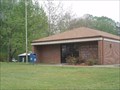
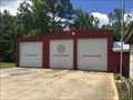 view gallery view gallerySE15.6 km |  Mentone Fire Dept. Mentone Fire Dept.
in Firehouses Fire Department serving Mentone posted by: stinger503 location: Alabama date approved: 01/18/2018 last visited: never |
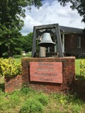 view gallery view gallery S15.9 km S15.9 km
|  Winston Memorial Presbyterian Church Bell - Valley Head, AL Winston Memorial Presbyterian Church Bell - Valley Head, AL
in Bells Bell at an older church posted by: stinger503 location: Alabama date approved: 01/23/2018 last visited: never |
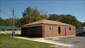 view gallery view gallery N16.6 km N16.6 km
|  Higdon, Alabama 35979 Higdon, Alabama 35979
in U.S. Post Offices This stand alone post office serves the small town of Higdon, Alabama and the nearby rural areas. posted by: miatabug location: Alabama date approved: 12/06/2011 last visited: never |
 view gallery view galleryN17.5 km | Higdon, AL 35979 in U.S. Post Offices This is the post office in Higdon Al. posted by: PostOfficeMan location: Alabama date approved: 07/30/2007 last visited: never |
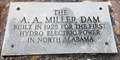
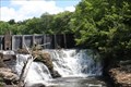
 view gallery view gallerySE18.5 km |  First - Hydro Electriec power Dam in North Alabama, Valley Head, AL First - Hydro Electriec power Dam in North Alabama, Valley Head, AL
in First of its Kind The A. A. Miller dam was built in 1925 for the first hydro electric power in North Alabama. posted by: hummerstation location: Alabama date approved: 05/13/2024 last visited: never |
 view gallery view gallerySE18.5 km | A. A. Miller Dam, Valley Head, AL in Alabama Historical Markers The A. A. Miller Dam historical marker is located in an area of DeSoto State Park at an overlook of the dam and the pool formed by DeSoto Falls. posted by: hummerstation location: Alabama date approved: 04/02/2024 last visited: never |
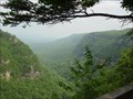
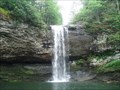
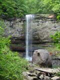
 view gallery view gallerySE18.5 km |  Desoto Falls, Fort Payne, ALA Desoto Falls, Fort Payne, ALA
in Waterfalls Desoto Falls located just outside Fort Payne, Alabama is a quite spot with a very scenic waterfall. posted by: Rat Rat location: Alabama date approved: 01/08/2010 last visited: 06/15/2016 |
 view gallery view gallerySE18.8 km |  Bankhead Cemetery, Mentone, AL Bankhead Cemetery, Mentone, AL
in Worldwide Cemeteries Bankhead Cemetery is located at 2203 Co. Rd. 642. posted by: hummerstation location: Alabama date approved: 05/10/2024 last visited: never |
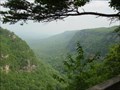
 view gallery view gallery NE20.8 km NE20.8 km
|  Cloudland Canyon State Park - Georgia Cloudland Canyon State Park - Georgia
in Wikipedia Entries Cloudland Canyon State Park is a 3,485 acre (14.10 km²) Georgia state park located near Trenton and Cooper Heights on the western edge of Lookout Mountain. posted by: CM-14 location: Georgia date approved: 08/05/2007 last visited: 07/05/2008 |
 view gallery view galleryNE20.8 km |  Cloudland Canyon State Park - Georgia Cloudland Canyon State Park - Georgia
in State/Provincial Parks Cloudland Canyon State Park is a 3,485 acre (14.10 km²) Georgia state park located near Trenton and Cooper Heights on the western edge of Lookout Mountain. posted by: CM-14 location: Georgia date approved: 08/14/2007 last visited: 07/05/2008 |
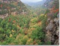 view gallery view galleryNE20.8 km |  Cloudland Canyon State Park Cloudland Canyon State Park
in Campgrounds One of my favorite places to tent camp is Cloudland Canyon State Park. posted by: Atlanta Highland Bagpiper location: Georgia date approved: 04/14/2006 last visited: 02/09/2008 |
 view gallery view galleryNE20.9 km | Unnamed Waterfall at Cloudland Canyon State Park in Waterfalls This is a waterfall at Cloudland Canyon State Park in north west Georgia. posted by: PostOfficeMan location: Georgia date approved: 07/31/2007 last visited: 02/08/2008 |
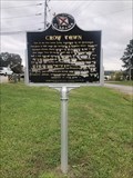 view gallery view gallery NW21.2 km NW21.2 km
| Crow Town in Alabama Historical Markers Located on the northbound side of Patterson Road at the entrance of a fishing ramp access point. posted by: flyingmoose location: Alabama date approved: 12/18/2021 last visited: never |
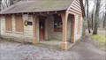 view gallery view galleryS22 km |  DeSoto State Park Contact Station, Fort Payne, AL DeSoto State Park Contact Station, Fort Payne, AL
in Civilian Conservation Corps The DeSoto State Park Contact Station was built by CCC Company 472. posted by: hummerstation location: Alabama date approved: 04/04/2024 last visited: never |
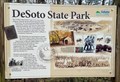 view gallery view galleryS22 km | DeSoto State Park, Fort Payne, AL in Alabama Historical Markers The DeSoto State Park is located at the Contact Station, the original entrance to DeSoto State Park. posted by: hummerstation location: Alabama date approved: 05/11/2024 last visited: never |
 view gallery view galleryS22 km | Civilian Conservation Corps Quarry, Fort Payne, AL in Civilian Conservation Corps The Civilian Conservation Corps Quarry is located on the CCC Quarry Trail in DeSoto State Park. posted by: hummerstation location: Alabama date approved: 04/02/2024 last visited: never |
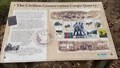
 view gallery view galleryS22 km | The Civilian Conservation Corps Quarry, Fort Payne, AL in Alabama Historical Markers The The Civilian Conservation Corps Quarry is located at the site of a CCC quarry on the CCC Quarry Trail in DeSoto State Park. posted by: hummerstation location: Alabama date approved: 04/02/2024 last visited: never |
 view gallery view galleryNE22.4 km | Un-named Horsetail Falls in Clouldland Canyon State Park - Georgia in Waterfalls 1 of 2 un-named falls along Daniel Creek in Cloudland Canyon State Park. posted by: CM-14 location: Georgia date approved: 08/04/2007 last visited: 02/08/2008 |
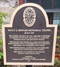 view gallery view galleryS22.4 km | Sally A. Howard Memorial Chapel, Mentone, AL in Alabama Historical Markers The Sally A. Howard Memorial Chapel is located near the corner of County Roads 165 and 617 in Mentone, AL. posted by: hummerstation location: Alabama date approved: 04/02/2024 last visited: never |
|