 view gallery view gallery E2.4 km E2.4 km
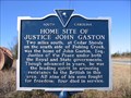
|   Home Site of Justice John Gaston Home Site of Justice John Gaston
in South Carolina Historical Markers Marker placed on the side of the road to draw attention to Justice John Gaston's homesite. posted by:  Hawaiian Ninja Hawaiian Ninja location: South Carolina date approved: 12/31/2008 last visited: 01/22/2017 |
 view gallery view gallery NW9 km NW9 km
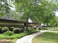
|  I77 NB Rest Area - Lando, SC I77 NB Rest Area - Lando, SC
in Highway Rest Areas Rest area for I77 north near Richburg. posted by: ChapterhouseInc location: South Carolina date approved: 07/06/2010 last visited: 12/18/2019 |
 view gallery view galleryNW9.2 km | I77 SB Rest Area - Lando, SC in Highway Rest Areas Small rest area for southbound I77 travelers. posted by: ChapterhouseInc location: South Carolina date approved: 07/16/2010 last visited: 05/03/2014 |
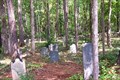 view gallery view gallery NE12.1 km NE12.1 km
|  Old Stone Cemetery at Landsford, Chester County, SC Old Stone Cemetery at Landsford, Chester County, SC
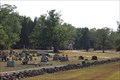
in Abandoned Cemeteries This old cemetery fenced in field stone is located in the woods beside Landsford Road, in Chester County, SC. The site is between 1/2 acre and 1 acre in size and is badly overgrown although visitors have made usable paths throughout the cemetery. posted by:  whamo2p whamo2p location: South Carolina date approved: 08/27/2007 last visited: 05/20/2017 |
 view gallery view gallery SE13.2 km SE13.2 km
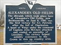
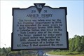
| ALEXANDER'S OLD FIELD in South Carolina Historical Markers Erected by the Chester County Historical Society 1978 posted by: Mvillian location: South Carolina date approved: 02/24/2008 last visited: 07/04/2017 |
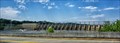 view gallery view gallerySE13.5 km |  Fishing Creek Hydro Station - Great Fall SC Fishing Creek Hydro Station - Great Fall SC
in Water Dams Built in 1916 by the Southern Power Company. posted by: nomadwillie location: South Carolina date approved: 11/14/2016 last visited: 07/04/2017 |
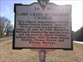 view gallery view gallerySE14.3 km | 29 21 - Camp Creek Methodist Church in South Carolina Historical Markers Historical marker for Camp Creek Methodist Church located on SC route 200 in Lancaster County SC posted by: gpsblake location: South Carolina date approved: 02/13/2015 last visited: 07/04/2017 |
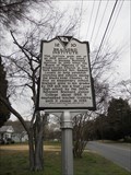
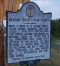
 view gallery view galleryNE16.4 km |  Historic Old Waxhaw Presbyterian Church and Cemetery Historic Old Waxhaw Presbyterian Church and Cemetery
in Churchyard Cemeteries The Historic old Waxhaw Presbyterian Church, organized in 1758, is the first church established in upper South Carolina. Tombstones date from 1758, and include the graves of many Revolutionary War patriots and prominent historic people. posted by: whamo2p location: South Carolina date approved: 08/25/2007 last visited: 06/09/2018 |
 view gallery view galleryE18.7 km | Lancasterville Presbyterian Church in South Carolina Historical Markers This historic marker is right outside the historic Lancasterville Presbyterian Church. posted by: Hawaiian Ninja location: South Carolina date approved: 12/24/2010 last visited: 01/22/2017 |
 view gallery view galleryE18.8 km | Robert Mills / The Jail SCHM 29-5 in South Carolina Historical Markers Great bit of history learned here, not only did Robert Mills design the Washington Monument but is the designer of this old "gaol". posted by: NCDaywalker location: South Carolina date approved: 02/01/2017 last visited: 02/01/2017 |
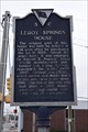 view gallery view galleryE18.8 km | Leroy Springs House SCHM 29-17 in South Carolina Historical Markers This historical marker in Lancaster, SC markers the home of a prominent citizen of Lancaster. posted by: NCDaywalker location: South Carolina date approved: 01/24/2017 last visited: 01/21/2017 |
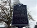
 view gallery view galleryE19 km | The Courthouse Lancaster County in South Carolina Historical Markers The Courthouse Lancaster County
Built in 1825-1828. posted by: BIO-HAZRD location: South Carolina date approved: 05/19/2015 last visited: 01/22/2017 |
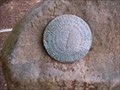
 view gallery view gallery N19 km N19 km
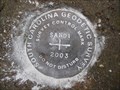
|  DG5125(SANDI) - York County SC DG5125(SANDI) - York County SC
in U.S. Benchmarks This is the South Carolina Geodetic Survey control mark SANDI, on Long Meadow Road in York County, SC. posted by: shorbird location: South Carolina date approved: 04/30/2013 last visited: never |
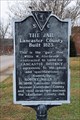
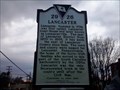 view gallery view galleryE19 km | Lancaster in South Carolina Historical Markers This historic marker is located in downtown Lancaster. There is a nice mural and artwork closeby. posted by: Hawaiian Ninja location: South Carolina date approved: 12/24/2010 last visited: 01/22/2017 |
 view gallery view galleryE19 km |  Lancaster, SC 29720 USPO Lancaster, SC 29720 USPO
in U.S. Post Offices The downtown USPO is located at 301 S Main Street, Lancaster, SC. It serves the City of Lancaster and surrounding rural areas. posted by: NCDaywalker location: South Carolina date approved: 01/26/2017 last visited: 01/27/2017 |
 view gallery view galleryNE20 km | 29-31 Ashe's Ferry in South Carolina Historical Markers Nice little bit of history about a crossing spot on the Catawba River that is near Lancaster and York County lines. posted by: NCDaywalker location: South Carolina date approved: 11/15/2018 last visited: 10/17/2022 |
 view gallery view gallery W20.3 km W20.3 km
| Brainerd Institute 12-10 in South Carolina Historical Markers The Brainerd Institute marker is located at Lancaster Street & Wilson Street, and a stone marker is located on the old school property at Cemetery Street & Marquis Street. posted by: BIO-HAZRD location: South Carolina date approved: 12/25/2015 last visited: 01/22/2017 |
 view gallery view galleryNE20.3 km | Waxhaw Presbyterian Church in South Carolina Historical Markers The Old Waxhaw Presbyterian Church, the oldest church in upstate South Carolina was founded 1750, and listed in the National Register of Historic Places in 1975. The church still has an active congregation, and the cemetary has recent graves as well those of revolutionary war patriots and other historic leaders. posted by: whamo2p location: South Carolina date approved: 09/03/2007 last visited: 06/09/2018 |
 view gallery view galleryNE21.2 km | EC1655 in U.S. Benchmarks Stone monument at the NC/SC boundary - located near Van Wyck, SC, just off U.S. 521 N on E. North Corner Rd. posted by: 3newsomes location: South Carolina date approved: 07/06/2010 last visited: 04/18/2022 |
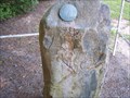 view gallery view galleryNE21.2 km |  NC / SC Boundary Marker NC / SC Boundary Marker
in U.S. Historic Survey Stones and Monuments Stone monument at the NC/SC boundary - located near Van Wyck, SC, just off U.S. 521 N on E. North Corner Rd. posted by: 3newsomes location: South Carolina date approved: 07/06/2010 last visited: 04/18/2022 |
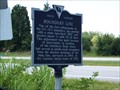 view gallery view galleryNE21.2 km | Boundary Line in South Carolina Historical Markers Marker 29-14, located near Van Wyck, SC, at the intersection of Charlotte Highway (U.S. 521) and East North Corner Road posted by: 3newsomes location: South Carolina date approved: 07/05/2010 last visited: 08/09/2014 |
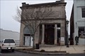 view gallery view galleryW21.6 km |  The Peoples Bank - Chester, SC, USA The Peoples Bank - Chester, SC, USA
in Converted Bank Buildings In the main business district, The Peoples Bank catches your eye with its stately stature. Now housing the local Chamber of Commerce, the local bank building is the community center for businesses of the area. posted by: NCDaywalker location: North Carolina date approved: 03/22/2017 last visited: 03/30/2017 |
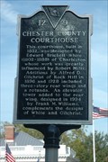 view gallery view galleryW21.7 km | 12-9 Chester County Courthouse in South Carolina Historical Markers Chester County Courthouse located in Chester, SC posted by: Barking Moonbat location: South Carolina date approved: 10/26/2009 last visited: 01/22/2017 |
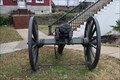 view gallery view galleryW21.7 km |  Confederate Parrott Field Rifle, 1863 - Chester, SC, USA Confederate Parrott Field Rifle, 1863 - Chester, SC, USA
in Static Artillery Displays A Confederate Civil War artillery piece is sitting on the front lawn of the Chester County Courthouse building on Saluda Street. posted by: NCDaywalker location: South Carolina date approved: 01/24/2017 last visited: 01/21/2017 |
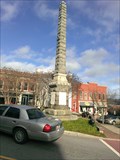 view gallery view galleryW21.7 km |  Chester Confederate War Memorial - Chester, SC Chester Confederate War Memorial - Chester, SC
in American Civil War Monuments and Memorials Confederate memorial in the center of downtown Chester, SC posted by: gpsblake location: South Carolina date approved: 03/17/2015 last visited: 01/22/2017 |
|