 view gallery view gallery E13.5 km E13.5 km
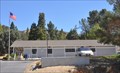
|   Lake Hughes, California 93532 Lake Hughes, California 93532
in U.S. Post Offices This Post Office is located at 16817 Elizabeth Lake Road in Lake Hughes, California. posted by:  brwhiz brwhiz location: California date approved: 08/20/2013 last visited: 09/28/2014 |
 view gallery view galleryE14.2 km |  Lake Hughes ~ Population 500 Lake Hughes ~ Population 500
in Population Signs This combination Elevation/Population sign is on the north side of Elizabeth Lake Road at the eastern town limits of Lake Hughes, California. posted by: brwhiz location: California date approved: 08/25/2013 last visited: never |
 view gallery view galleryE14.2 km |  Lake Hughes ~ Elevation 3250 Lake Hughes ~ Elevation 3250
in Elevation Signs This combination Elevation/Population sign is on the north side of Elizabeth Lake Road at the eastern town limits of Lake Hughes, California. posted by: brwhiz location: California date approved: 08/23/2013 last visited: never |
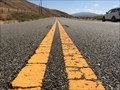 view gallery view gallery NW14.2 km NW14.2 km
|  Ridge Route - Gorman, CA Ridge Route - Gorman, CA
in Wikipedia Entries The original road between Los Angeles and Bakersfield went through here before Interstate 5 was built. This is old U.S. Highway 99. posted by: bluesnote location: California date approved: 01/14/2017 last visited: 12/29/2018 |
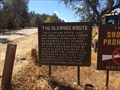 view gallery view galleryNW14.2 km |  The Old Ridge Route - Gorman, CA The Old Ridge Route - Gorman, CA
in U.S. Route 99 - The Pacific Highway The original road between Los Angeles and Bakersfield went through here before Interstate 5 was built. This is old U.S. Highway 99. posted by: bluesnote location: California date approved: 03/24/2016 last visited: 12/29/2018 |
 view gallery view galleryNW14.2 km |  Ridge Route - Gorman, CA Ridge Route - Gorman, CA
in U.S. National Register of Historic Places The original road between Los Angeles and Bakersfield went through here before Interstate 5 was built. This is old U.S. Highway 99. posted by: bluesnote location: California date approved: 01/13/2017 last visited: 12/29/2018 |
 view gallery view galleryNW14.2 km |  The Old Ridge Route - Gorman, CA The Old Ridge Route - Gorman, CA
in Signs of History This sign is along a rural backroad near Gorman. posted by: bluesnote location: California date approved: 10/19/2014 last visited: 12/29/2018 |
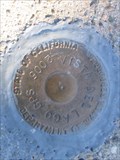
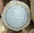
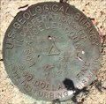 view gallery view galleryE15.1 km |  U.S. Geological Survey K-19 Mark - Lake Hughes, CA U.S. Geological Survey K-19 Mark - Lake Hughes, CA
in U.S. Benchmarks This is one of a few benchmarks in the area. posted by: bluesnote location: California date approved: 10/20/2014 last visited: 10/20/2014 |
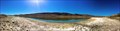 view gallery view galleryE15.1 km | Elizabeth Lake - Lake Hughes, CA in Wikipedia Entries A lake along the San Andreas Fault. posted by: bluesnote location: California date approved: 11/25/2014 last visited: 11/25/2014 |
 view gallery view galleryE15.1 km |  Elizabeth Lake - Lake Hughes, CA Elizabeth Lake - Lake Hughes, CA
in Natural Lakes A lake along the San Andreas Fault. posted by: bluesnote location: California date approved: 12/02/2014 last visited: 12/02/2014 |
 view gallery view galleryE15.1 km |  Elizabeth Lake - Lake Hughes, CA Elizabeth Lake - Lake Hughes, CA
in Places of Geologic Significance A lake along the San Andreas Fault. posted by: bluesnote location: California date approved: 11/26/2014 last visited: 11/26/2014 |
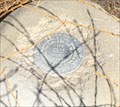
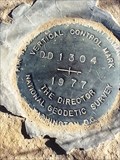 view gallery view gallery SW15.9 km SW15.9 km
| Vertical Control Marker National Geodetic Survey 1977 DD 1304 in U.S. Benchmarks Vertical Control Marker National Geodetic Survey 1977 DD 1304 on Old Ridge Route just east of I 5. posted by: ghhs72 location: California date approved: 01/02/2014 last visited: 12/31/2013 |
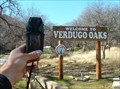 view gallery view gallerySW16.3 km |  Verdugo Oaks, California Verdugo Oaks, California
in Boy Scout Camps Verdugo Oaks Camp in Southern California. posted by:  showbizkid showbizkid location: California date approved: 01/26/2006 last visited: never |
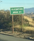 view gallery view gallerySW16.9 km | Interstate 5 (Southbound) ~ Elevation 2,000 in Elevation Signs An elevation sign near Santa Clarita along Interstate 5, southbound lanes towards Los Angeles. posted by: bluesnote location: California date approved: 10/22/2016 last visited: 10/22/2016 |
 view gallery view gallery W17.1 km W17.1 km
| Vista del Lago - Benchmark in U.S. Benchmarks Benchmark in the sidewalk in front of the Vista del Lago Visitors Center posted by: fishingwishing location: California date approved: 01/17/2008 last visited: 05/22/2009 |
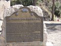 view gallery view gallery S17.1 km S17.1 km
|  ST. FRANCIS DAM DISASTER SITE ST. FRANCIS DAM DISASTER SITE
in California Historical Markers Pumphouse 2 was destroyed by the catastrophic failure of the St. Francisquito Dam in 1928 along with many other buildings and people between this point and Ventura. posted by: TerryDad2 location: California date approved: 03/18/2007 last visited: 04/06/2018 |
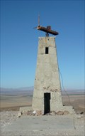 view gallery view gallery NE17.5 km NE17.5 km
|  Mystery Tower Mystery Tower
in Weird Story Locations The mystery tower west of Lancaster posted by: GKrynen location: California date approved: 02/11/2009 last visited: 08/18/2010 |
 view gallery view galleryS18.2 km |  Water Dam - Castaic, CA USA Water Dam - Castaic, CA USA
in Water Dams Castaic Lake State Recreation Area
32132 Castaic Lake Drive
Castaic, CA 91384
661) 257-4050 posted by: CacheKidz! location: California date approved: 05/21/2017 last visited: 03/18/2018 |
 view gallery view galleryE18.5 km |  Switching Station, Elizabeth Lake, CA Switching Station, Elizabeth Lake, CA
in Historic Transformer Sub-Stations Buildings Abandoned power distribution station built in 1911 for the Pacific Electric Railway. posted by: CraigBaker location: California date approved: 02/27/2024 last visited: never |
 view gallery view galleryW19.2 km | Slide 2 1970 Benchmark in U.S. Benchmarks Slide 2 is an orphan USGS benchmark on Slide Mountain. posted by: showbizkid location: California date approved: 02/24/2006 last visited: never |
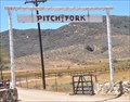
 view gallery view galleryE19.5 km |  Pitch Fork Ranch Entrance Arch Pitch Fork Ranch Entrance Arch
in Freestanding Arches This Freestanding Arch marks the entrance to the Pitch Fork Llama Ranch, located at 13500 Lake Elizabeth Road between Lake Hughes and Leona Valley, California. posted by: brwhiz location: California date approved: 08/23/2013 last visited: never |
 view gallery view galleryE19.5 km |  Pitch Fork Ranch ~ Lake Hughes, California Pitch Fork Ranch ~ Lake Hughes, California
in Named Farms and Ranches This Named Ranch is located at 13500 Lake Elizabeth Road between Lake Hughes and Leona Valley, California posted by: brwhiz location: California date approved: 08/22/2013 last visited: never |
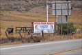 view gallery view galleryE19.5 km |  Pitch Fork Ranch ~ Lake Hughes, California Pitch Fork Ranch ~ Lake Hughes, California
in Alpaca and Llama Farms This Llama Ranch is located at 13500 Lake Elizabeth Road between Lake Hughes and Leona Valley, California posted by: brwhiz location: California date approved: 08/24/2013 last visited: never |
 view gallery view galleryNW20.4 km | U.S. Coast & Geodetic Survey V 973 RESET Benchmark - Gorman, CA in U.S. Benchmarks This is one of many benchmarks along Gorman Post Rd. posted by: bluesnote location: California date approved: 10/20/2014 last visited: 10/20/2014 |
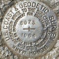 view gallery view galleryNW20.6 km | U.S. Coast & Geodetic Survey S 973 Benchmark - Gorman, CA in U.S. Benchmarks This is one of many benchmarks along Gorman Post Rd. posted by: bluesnote location: California date approved: 09/29/2014 last visited: 12/29/2018 |
|