 view gallery view gallery N3.4 km N3.4 km
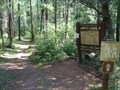
|   See Canyon Trail #184, Tonto National Forest See Canyon Trail #184, Tonto National Forest
in Hiking and walking trailheads The See Canyon Trail is a gorgeous and adventurous hike from Christopher Creek to the top of the Mogollon Rim. posted by:  simpjkee simpjkee location: Arizona date approved: 04/24/2010 last visited: 12/25/2010 |
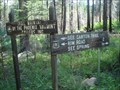 view gallery view galleryN4.7 km | See Spring Trail #185, Tonto National Forest in Hiking and walking trailheads The See Spring Trail is a beautiful hike from Christopher Creek to See Spring. posted by: simpjkee location: Arizona date approved: 04/24/2010 last visited: 12/26/2010 |
 view gallery view gallery NW5.8 km NW5.8 km
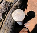
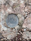
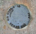
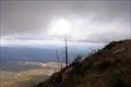
|  US GLOS 1934, Promontory Butte, AZ US GLOS 1934, Promontory Butte, AZ
in U.S. Benchmarks A boundary mark at the edge of the Mogollon Rim, between Coconino and Gila Counties. posted by:  dcrep dcrep location: Arizona date approved: 10/23/2008 last visited: never |
 view gallery view gallery E6.4 km E6.4 km
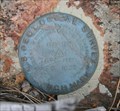
| US GLOS 1934, Crook Campground, AZ in U.S. Benchmarks A boundary mark just south of Woods Canyon Lake near Forest Lakes, AZ posted by: dcrep location: Arizona date approved: 10/07/2008 last visited: never |
 view gallery view galleryE6.8 km | 1744-A1 - Arizona DOT 1979 in U.S. Benchmarks Along Old Rim Road near Payson, Arizona. An Arizona DOT survey mark. posted by: dcrep location: Arizona date approved: 10/07/2008 last visited: never |
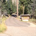
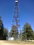 view gallery view galleryN7.1 km |  Promontory Point Look-out Tower Promontory Point Look-out Tower
in Look-Out Towers Forest Service Look-out tower utilized during emergencies posted by: philbeer location: Arizona date approved: 08/02/2013 last visited: never |
 view gallery view gallery W7.7 km W7.7 km
| Kohlsr Survey Marker - Star Valley, AZ in U.S. Benchmarks This survey mark is on a hill overlooking Kohl's Ranch Lodge outside of Star Valley, Arizona. posted by: rjmcdonough1 location: Arizona date approved: 10/20/2018 last visited: never |
 view gallery view galleryW7.9 km |  Kohl's Ranch Amphitheater - Star Valley, AZ Kohl's Ranch Amphitheater - Star Valley, AZ
in Outdoor Amphitheaters This rustic amphitheater sits under the pines at Kohl's Ranch Guest Lodge. posted by: rjmcdonough1 location: Arizona date approved: 10/21/2018 last visited: 10/21/2018 |
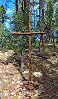 view gallery view galleryW7.9 km |  Cross at the open air chapel, Kohl's Ranch - Star Valley, AZ Cross at the open air chapel, Kohl's Ranch - Star Valley, AZ
in Christian Crosses This cross stands in the front of the amphitheatre known as the Open Air Chapel for the Kohl's Ranch Lodge outside of Star Valley, Arizona. posted by: rjmcdonough1 location: Arizona date approved: 10/21/2018 last visited: 10/21/2018 |
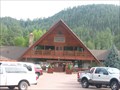 view gallery view galleryW7.9 km |  Kohl’s Ranch Lodge - Kohl’s Ranch, Arizona Kohl’s Ranch Lodge - Kohl’s Ranch, Arizona
in Lodge-Style Accommodations Located in the Central Arizona highlands, Kohl's Ranch Lodge provides an escape from the summer heat and year round enjoyment of Arizona's Zane Grey County. posted by: adenium location: Arizona date approved: 04/08/2010 last visited: 10/15/2018 |
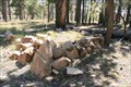
 view gallery view galleryW8.7 km |  Texas-Arizona CCC Co. 807 Texas-Arizona CCC Co. 807
in Civilian Conservation Corps Located in the Tonto National Forest, the Indian Gardens Camp was established in 1933 near Kohl's Ranch. The camp flagpole was made of stone and still stands today in excellent condition. posted by: roadrunners location: Arizona date approved: 06/20/2013 last visited: 09/07/2023 |
 view gallery view galleryE10.1 km |  Mogollon Rim - Central, AZ Mogollon Rim - Central, AZ
in Wikipedia Entries The Mogollon Rim is a geological feature running 200 miles across central Arizona. posted by: rjmcdonough1 location: Arizona date approved: 08/11/2018 last visited: 05/18/2021 |
 view gallery view galleryE10.1 km |  Mogollon Rim - Sitgreaves National Forest, AZ Mogollon Rim - Sitgreaves National Forest, AZ
in Places of Geologic Significance The Mogollon Rim, also known as the Tonto Rim, crosses central Arizona. posted by: rjmcdonough1 location: Arizona date approved: 08/17/2018 last visited: 05/18/2021 |
 view gallery view galleryE10.5 km |  General Crook Trail - Forest Lakes, AZ General Crook Trail - Forest Lakes, AZ
in Wagon Roads and Trails The General Crook Trail was an army trail connecting forts across Arizona. posted by: rjmcdonough1 location: Arizona date approved: 08/08/2018 last visited: never |
 view gallery view galleryE10.6 km |  Mogollon Rim Visitor's Center - Sitgreaves National Forest, AZ 7500 Feet Mogollon Rim Visitor's Center - Sitgreaves National Forest, AZ 7500 Feet
in Elevation Signs This sign provides the altitude for the visitor center and ranger station on the Mogollon Rim in the Sitgreaves National Forest. posted by: rjmcdonough1 location: Arizona date approved: 08/11/2018 last visited: 05/18/2021 |
 view gallery view galleryE10.6 km |  Mogollon Rim Visitor Center - Forest Lakes, AZ Mogollon Rim Visitor Center - Forest Lakes, AZ
in Ranger Stations This visitor center and ranger station provides information on the Mogollon Rim in the Sitgreaves National Forest. posted by: rjmcdonough1 location: Arizona date approved: 08/07/2018 last visited: 05/18/2021 |
 view gallery view galleryE10.6 km | USGS M1 1934 in U.S. Benchmarks A USGS elevation benchmark near Al Fulton Point along the Mogollon Rim in Arizona. posted by: dcrep location: Arizona date approved: 07/14/2009 last visited: never |
 view gallery view galleryNW10.9 km | USGS R22 1933 in U.S. Benchmarks A USGS elevation benchmark west of Promontory Butte along the Mogollon Rim in Arizona. posted by: dcrep location: Arizona date approved: 05/31/2009 last visited: never |
 view gallery view galleryE11.3 km |  Al Fulton - Fulton Point, Sitgreaves National Forest, AZ Al Fulton - Fulton Point, Sitgreaves National Forest, AZ
in Out of Place Graves Al Fulton's grave is a short walk off Hwy. 290 on the Mogollon Rim in Arizona. posted by: rjmcdonough1 location: Arizona date approved: 08/10/2018 last visited: never |
 view gallery view galleryE11.3 km |  Al Fulton - Fulton Point, Sitgreaves National Forest, AZ Al Fulton - Fulton Point, Sitgreaves National Forest, AZ
in Graves Mentioning a Cause of Death Al Fulton's grave is a short walk off Hwy. 290 on the Mogollon Rim in Arizona. posted by: rjmcdonough1 location: Arizona date approved: 12/31/2018 last visited: never |
 view gallery view galleryNW11.7 km |  Tonto Creek Fish Hatchery - Tonto National Forest - Payson, AZ Tonto Creek Fish Hatchery - Tonto National Forest - Payson, AZ
in Fish Hatcheries A fish hatchery deep in the Tonto National Forest. posted by: jennyanykind location: Arizona date approved: 01/15/2016 last visited: never |
 view gallery view galleryNW13.4 km | G. D. Bantz Gravesite in Out of Place Graves The grave of G. D. Bantz, alongside Rim Road (route 300) north of Payson, Arizona. posted by: dcrep location: Arizona date approved: 09/30/2008 last visited: never |
| view gallery NW13.8 km |  Promontory Point Look-out Tower - Show Low, AZ Promontory Point Look-out Tower - Show Low, AZ
in Elevated Buildings Forest Service Look-out tower utilized during emergencies posted by: bluesnote location: Arizona date approved: 06/24/2021 last visited: 06/24/2021 |
 view gallery view galleryNW14 km | USGS R20 1933 in U.S. Benchmarks A USGS elevation benchmark just east of Myrtle Point along the Mogollon Rim in Arizona. posted by: dcrep location: Arizona date approved: 05/31/2009 last visited: never |
 view gallery view galleryNW14.8 km |  Myrtle Point Myrtle Point
in Scenic Overlooks Myrtle Point posted by: jdwest32 location: Arizona date approved: 08/12/2008 last visited: 11/01/2009 |
|