 view gallery view gallery E2.7 km E2.7 km
|   New Mexico-Colorado Principal Meridian New Mexico-Colorado Principal Meridian
in U.S. Benchmarks This is PID AI5439 INITIAL POINT, which is the disk replacing the pile of rocks that was used as the starting point for civil surveying of New Mexico and southern Colorado posted by:  BuckBrooke BuckBrooke location: New Mexico date approved: 03/15/2006 last visited: never |
 view gallery view gallery NE2.9 km NE2.9 km
| U.S. Dept. of Interior Fish and Wildlife Service 'PT 389' in U.S. Benchmarks A US Department of Interior Fish and Wildlife Service pipecap. posted by: BuckBrooke location: New Mexico date approved: 03/15/2006 last visited: never |
 view gallery view galleryNE6.1 km |  Acomilla - Northbound- New Mexico Acomilla - Northbound- New Mexico
in New Mexico Historical Markers This is a twin to the SOUTHBOUND "Acomilla" sign. posted by:  Queens Blessing Queens Blessing location: New Mexico date approved: 11/19/2011 last visited: 02/15/2013 |
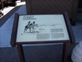 view gallery view galleryNE6.1 km |  Seviletta Wildlife Refuge, Socorro County, NM - Northbound Seviletta Wildlife Refuge, Socorro County, NM - Northbound
in Signs of History This sign provides the history behind the Seviletta Wildlife Refuge. It is a twin to the sign on the southbound side of I-25. posted by: Queens Blessing location: New Mexico date approved: 11/21/2011 last visited: 09/02/2013 |
 view gallery view galleryNE6.3 km | Rio Salado Sand Dunes - Northbound, New Mexico in New Mexico Historical Markers This is a twin to the SOUTHBOUND "Rio Salado Sand Dunes" sign posted by: Queens Blessing location: New Mexico date approved: 11/19/2011 last visited: 10/07/2012 |
 view gallery view gallery N6.4 km N6.4 km
|  Walking Sands Rest Area, Interstate I-25, New Mexico -Southbound Walking Sands Rest Area, Interstate I-25, New Mexico -Southbound
in Highway Rest Areas This is the southbound rest area on Interstate 25 in Socorro County. posted by: Queens Blessing location: New Mexico date approved: 10/17/2011 last visited: 09/02/2013 |
 view gallery view galleryN6.4 km | Seviletta Wildlife Refuge, Socorro County, NM - Southbound in Signs of History This sign provides the history behind the Seviletta Wildlife Refuge. posted by: Queens Blessing location: New Mexico date approved: 10/16/2011 last visited: 09/02/2013 |
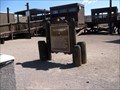
 view gallery view galleryN6.4 km |  Tribute to Randall G. Sanders, Socorro County, NM Tribute to Randall G. Sanders, Socorro County, NM
in Citizen Memorials This simple tribute is located in the southbound "Walking Sands" Rest area on Interstate 25. posted by: Queens Blessing location: New Mexico date approved: 10/16/2011 last visited: 09/02/2013 |
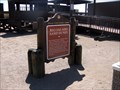
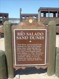 view gallery view galleryN6.4 km | RIO SALADO SAND DUNES - Historical Marker in New Mexico Historical Markers RIO SALADO Sand Dunes & Rest Area I-25 New Mexico posted by: GEO*Trailblazer 1 location: New Mexico date approved: 05/04/2007 last visited: 06/27/2013 |
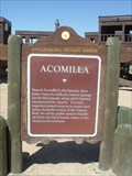 view gallery view galleryN6.4 km | ACOMILLA - Historical Marker in New Mexico Historical Markers ACOMILLA Historical Marker & Rest Stop I-25 New Mexico posted by: GEO*Trailblazer 1 location: New Mexico date approved: 05/04/2007 last visited: 05/31/2018 |
 view gallery view gallery S10.3 km S10.3 km
|  Lemitar, New Mexico 87823 Lemitar, New Mexico 87823
in U.S. Post Offices This Post Office is located at 5 Chambon Road in Lemitar, New Mexico. posted by: brwhiz location: New Mexico date approved: 11/02/2011 last visited: never |
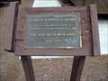
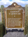 view gallery view galleryS10.5 km | Sabino Y Lemitar in New Mexico Historical Markers A New Mexico OSHM just off of I-25 at exit 156. posted by: leadhiker location: New Mexico date approved: 10/09/2011 last visited: never |
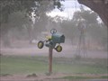 view gallery view galleryS19.2 km |  John Deer-look-a-like John Deer-look-a-like
in Themed Homemade Mailboxes Green and Yellow Tractor mailbox. posted by: EMHS Tracker location: New Mexico date approved: 06/25/2006 last visited: never |
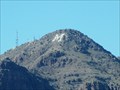 view gallery view galleryS20.1 km |  M in Socorro - Socorro, NM M in Socorro - Socorro, NM
in Satellite Imagery Oddities An M on Socorro Peak in Socorro, NM. posted by: saopaulo1 location: New Mexico date approved: 12/17/2016 last visited: never |
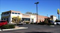
 view gallery view galleryS20.1 km |  McDonald's Socorro Free WiFi McDonald's Socorro Free WiFi
in Wi-Fi Hotspots Free WiFi Served Daily at the McDonald's located at 1102 N California Street in Socorro, New Mexico. posted by: brwhiz location: New Mexico date approved: 11/11/2012 last visited: never |
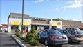 view gallery view galleryS20.1 km |  McDonald's Socorro McDonald's Socorro
in McDonald's Restaurants This McDonald's is located at 1102 N California Street in Socorro, New Mexico. posted by: brwhiz location: New Mexico date approved: 11/24/2012 last visited: never |
 view gallery view galleryS20.1 km |  McDonalds - Socorro, NM McDonalds - Socorro, NM
in Bookcrossing Zones McDonalds is a bookcrossing zone. posted by: saopaulo1 location: New Mexico date approved: 12/19/2016 last visited: never |
 view gallery view galleryS20.1 km |  Sonic - N California St, - Socorro, NM Sonic - N California St, - Socorro, NM
in Sonic Drive In Restaurants A Sonic on N California St. posted by: saopaulo1 location: New Mexico date approved: 12/15/2016 last visited: never |
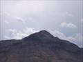 view gallery view galleryS20.3 km |  "M" Mountain, aka Socorro Peak "M" Mountain, aka Socorro Peak
in Letters on Hills "M" stands for School of "Mines" posted by: EMHS Tracker location: New Mexico date approved: 06/25/2006 last visited: 04/15/2024 |
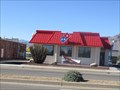
 view gallery view galleryS20.3 km |  Burger King - California Street - Socorro, NM Burger King - California Street - Socorro, NM
in Burger King Restaurants A Burger King on California in Socorro, NM. posted by: saopaulo1 location: New Mexico date approved: 12/15/2016 last visited: never |
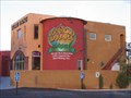 view gallery view galleryS20.3 km |  Socorro Springs Brew Pub Socorro Springs Brew Pub
in Brewpubs One of the best places to eat in town. If you are just passing through this is a must. posted by: EMHS Tracker location: New Mexico date approved: 06/25/2006 last visited: 04/03/2015 |
 view gallery view galleryS20.6 km |  Domino's - Socorro, NM Domino's - Socorro, NM
in Domino's Pizza A Domino's on California in Socorro, NM. posted by: saopaulo1 location: New Mexico date approved: 12/14/2016 last visited: never |
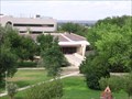 view gallery view galleryS20.6 km |  Martain Speare Building, New Mexico Institute of Mining and Technology Martain Speare Building, New Mexico Institute of Mining and Technology
in Octagon Buildings This is the computer science building at New Mexico Tech. posted by: EMHS Tracker location: New Mexico date approved: 06/25/2006 last visited: 08/08/2014 |
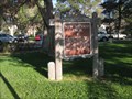 view gallery view galleryS20.6 km | New Mexico Tech, Socorro, NM in New Mexico Historical Markers This sign is located on the campus of New Mexico Tech. posted by: Queens Blessing location: New Mexico date approved: 11/13/2011 last visited: 08/17/2022 |
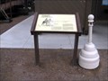
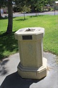 view gallery view galleryS20.6 km |  Class of 1929 Sundial -- New Mexico Tech, Soccorro NM Class of 1929 Sundial -- New Mexico Tech, Soccorro NM
in Sundials A sundial donated by the NMSM class of 1929 still tells solar time nearly 85 years later. posted by: Benchmark Blasterz location: New Mexico date approved: 09/10/2014 last visited: 09/13/2014 |
|