 view gallery view gallery SE6.3 km SE6.3 km
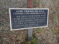
|   Jane Chandler Gill Jane Chandler Gill
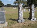
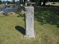
in Texas Historical Markers Missing its medallion, this Texas Historical Marker is one of four markers in Sam Houston Park, northwest of Blakeney on FM 410/Red River County Road 2381. It is at the grave site of Jane Chandler Gill, one of the oldest Caucasian burials in Texas. posted by:  QuarrellaDeVil QuarrellaDeVil location: Texas date approved: 05/03/2015 last visited: never |
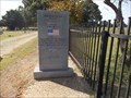
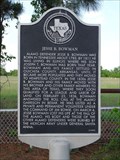 view gallery view gallerySE6.3 km | Jesse B. Bowman in Texas Historical Markers One of four Texas Historical Markers in Sam Houston Park, northwest of Blakeney on FM 410/Red River County Road 2381. This one pays homage to Jesse B. Bowman, who had lived in this area and who died at the Alamo. posted by: QuarrellaDeVil location: Texas date approved: 05/01/2015 last visited: never |
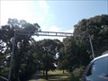
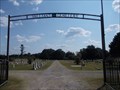
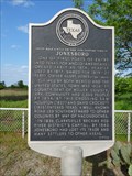 view gallery view gallerySE6.3 km | Jonesboro in Texas Historical Markers Texas Historical Marker near the site of Jonesboro, which was important to the area not only as a port of entry, but also because Sam Houston and David Crockett both crossed the Red River here to come to what would eventually become Texas. posted by: QuarrellaDeVil location: Texas date approved: 05/02/2015 last visited: never |
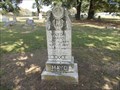
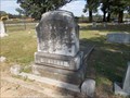
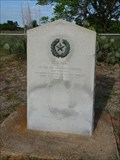 view gallery view gallerySE6.3 km | Sam Houston in Texas Historical Markers One of four Texas Historical Markers in Sam Houston Park, northwest of Blakeney on FM 410/Red River County Road 2381. This 1936 gray granite Texas Centennial Marker notes that Sam Houston first crossed into Texas near here back in 1832. posted by: QuarrellaDeVil location: Texas date approved: 05/02/2015 last visited: never |
 view gallery view gallerySE6.3 km |  Sam Houston's FIRST Footstep on Texas Soil - Red River County, TX Sam Houston's FIRST Footstep on Texas Soil - Red River County, TX
in First of its Kind This 1936 gray granite Texas Centennial Marker stands in Sam Houston Park, northwest of Blakeney on FM 410/Red River County Road 2381. It notes that Texas legend Sam Houston took his first step into what would become Texas, near here back in 1832. posted by: QuarrellaDeVil location: Texas date approved: 05/02/2015 last visited: never |
 view gallery view gallery W8 km W8 km
|  Kiamichi River Launch - Oklahoma Kiamichi River Launch - Oklahoma
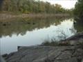
in Boat Ramps A paved Simple Launch posted by:  misfitt misfitt location: Oklahoma date approved: 02/14/2007 last visited: never |
 view gallery view gallery NE8.5 km NE8.5 km
|  Elliot Cemetery - Valliant, OK Elliot Cemetery - Valliant, OK
in Worldwide Cemeteries Elliot Cemetery is rather hidden and easily overlooked. posted by: hamquilter location: Oklahoma date approved: 11/07/2017 last visited: never |
 view gallery view galleryNE8.5 km |  Mack Lucas - Valliant Cem. - Valliant, OK Mack Lucas - Valliant Cem. - Valliant, OK
in Woodmen of the World Grave Markers/Monuments Mack Lucas' headstone stands next to his wife Lottie's, who died a mere two months after Mack. posted by: hamquilter location: Oklahoma date approved: 11/06/2017 last visited: never |
 view gallery view galleryNE8.7 km | Milton Mayo - Valliant Cem. - Valliant, OK in Woodmen of the World Grave Markers/Monuments Milton Mayo's headstone is one of several Woodmen of the World in this cemetery. posted by: hamquilter location: Oklahoma date approved: 11/06/2017 last visited: never |
 view gallery view galleryNE8.7 km | James Cooper Monk - Valliant Cem. - Valliant, OK in Woodmen of the World Grave Markers/Monuments James Monk's WOW headstone is located in Valliant Cemetery. posted by: hamquilter location: Oklahoma date approved: 11/06/2017 last visited: never |
 view gallery view galleryNE8.7 km | William C. Cotton - Valliant Cem. - Valliant, OK in Woodmen of the World Grave Markers/Monuments William Cotton was laid to rest in Valliant Cemetery. posted by: hamquilter location: Oklahoma date approved: 11/06/2017 last visited: never |
 view gallery view galleryNE8.7 km |  Amer Legion War Memorial - Valliant Cem - Valliant, OK Amer Legion War Memorial - Valliant Cem - Valliant, OK
in Non-Specific Veteran Memorials This war memorial honors all those who have served. posted by: hamquilter location: Oklahoma date approved: 11/10/2017 last visited: never |
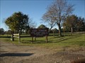
 view gallery view galleryNE8.7 km | Valliant Cemetery - Valliant, OK in Worldwide Cemeteries Valliant Cemetery lies west of the town of Valliant. posted by: hamquilter location: Oklahoma date approved: 11/06/2017 last visited: 05/19/2023 |
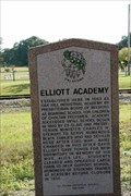 view gallery view galleryNE8.7 km |  Elliott Academy Elliott Academy
in Oklahoma Historical Markers Elliott Academy historical marker is located on the south side of US 70, just east of N450, near Valliant, OK. posted by: Lat34North location: Oklahoma date approved: 10/20/2009 last visited: 09/09/2017 |
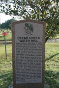 view gallery view galleryNE8.7 km | Clear Creek Water Mill in Oklahoma Historical Markers Clear Creek Water Mill historical marker is located on the south side of US 70, just east of N450, near Valliant, OK. posted by: Lat34North location: Oklahoma date approved: 10/20/2009 last visited: 09/09/2017 |
 view gallery view gallery NW9 km NW9 km
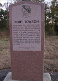
| Fort Towson - Fort Towson, Oklahoma in Oklahoma Historical Markers Fort Towson is under the protection of the Oklahoma Historical Society. posted by: gparkes location: Oklahoma date approved: 02/22/2010 last visited: 10/21/2021 |
 view gallery view galleryNW9 km | Fort Towson Landing - Fort Towson, OK in Oklahoma Historical Markers One of two pink granite historical markers on the south side of Highway 70 in Fort Towson, Oklahoma. posted by: The Snowdog location: Oklahoma date approved: 10/22/2021 last visited: never |
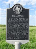 view gallery view gallerySE9.3 km | Arnold E. A. Roitsch Archeological Site in Texas Historical Markers Texas Historical Marker in the vicinity of the Arnold E. A. Archeological Site, in rural Red River County along FM 410/CR 2381. It notes the past presence of the Caddo people in this area before 1700. posted by: QuarrellaDeVil location: Texas date approved: 04/27/2015 last visited: never |
 view gallery view gallerySE9.3 km |  Arnold E. A. Roitsch Archeological Site - Red River County, TX Arnold E. A. Roitsch Archeological Site - Red River County, TX
in New World Ancient Evidence Known today as the Sam Kaufman Site, a 1992 Texas Historical Marker notes the general area of the Arnold E. A. Roitsch Archeological Site in northwestern Red River County, TX. posted by: QuarrellaDeVil location: Texas date approved: 09/03/2021 last visited: never |
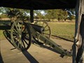 view gallery view galleryNW10 km |  Fort Towson Cannon - Fort Towson, Oklahoma Fort Towson Cannon - Fort Towson, Oklahoma
in Static Artillery Displays This Cannon is on the grounds of Fort Towson Historic Site. posted by: gparkes location: Oklahoma date approved: 11/21/2009 last visited: 10/04/2015 |
 view gallery view galleryNW10.1 km |  Fort Towson Historic Site - Fort Towson, Oklahoma Fort Towson Historic Site - Fort Towson, Oklahoma
in U.S. National Register of Historic Places This was the location of the last American Civil War Confederate General's surrender. posted by: gparkes location: Oklahoma date approved: 11/22/2009 last visited: 10/21/2021 |
 view gallery view galleryNW10.1 km |  Fort Towson Historic Site - Fort Towson, Oklahoma Fort Towson Historic Site - Fort Towson, Oklahoma
in Civil War Discovery Trail Sites This was the location of the last American Civil War Confederate General's surrender. posted by: gparkes location: Oklahoma date approved: 11/21/2009 last visited: 10/21/2021 |
 view gallery view galleryNW10.3 km |  High school/Gymnasium - Fort Towson, OK High school/Gymnasium - Fort Towson, OK
in WPA Projects Fort Towson High School is still using these WPA-constructed buildings. posted by: hamquilter location: Oklahoma date approved: 10/03/2017 last visited: never |
 view gallery view galleryNE10.6 km |  Water Tower - Valliant, OK Water Tower - Valliant, OK
in Water Towers This is a very large and tall water tower for this small town. posted by: hamquilter location: Oklahoma date approved: 11/08/2017 last visited: never |
 view gallery view galleryNE10.8 km |  Post Office - Valliant, OK 74764 Post Office - Valliant, OK 74764
in U.S. Post Offices This post office serves a community of about 750 residents. posted by: hamquilter location: Oklahoma date approved: 11/14/2017 last visited: never |
|